
Bus route 51 in London links “Hare Street” and “Orpington Station”. In one direction or the other it serves 2 stops that it skips on the way back. The return journey ends at “Beresford Sq/Woolwich Arsenal” (350 m from “Hare Street”).
Where bus 51 goes
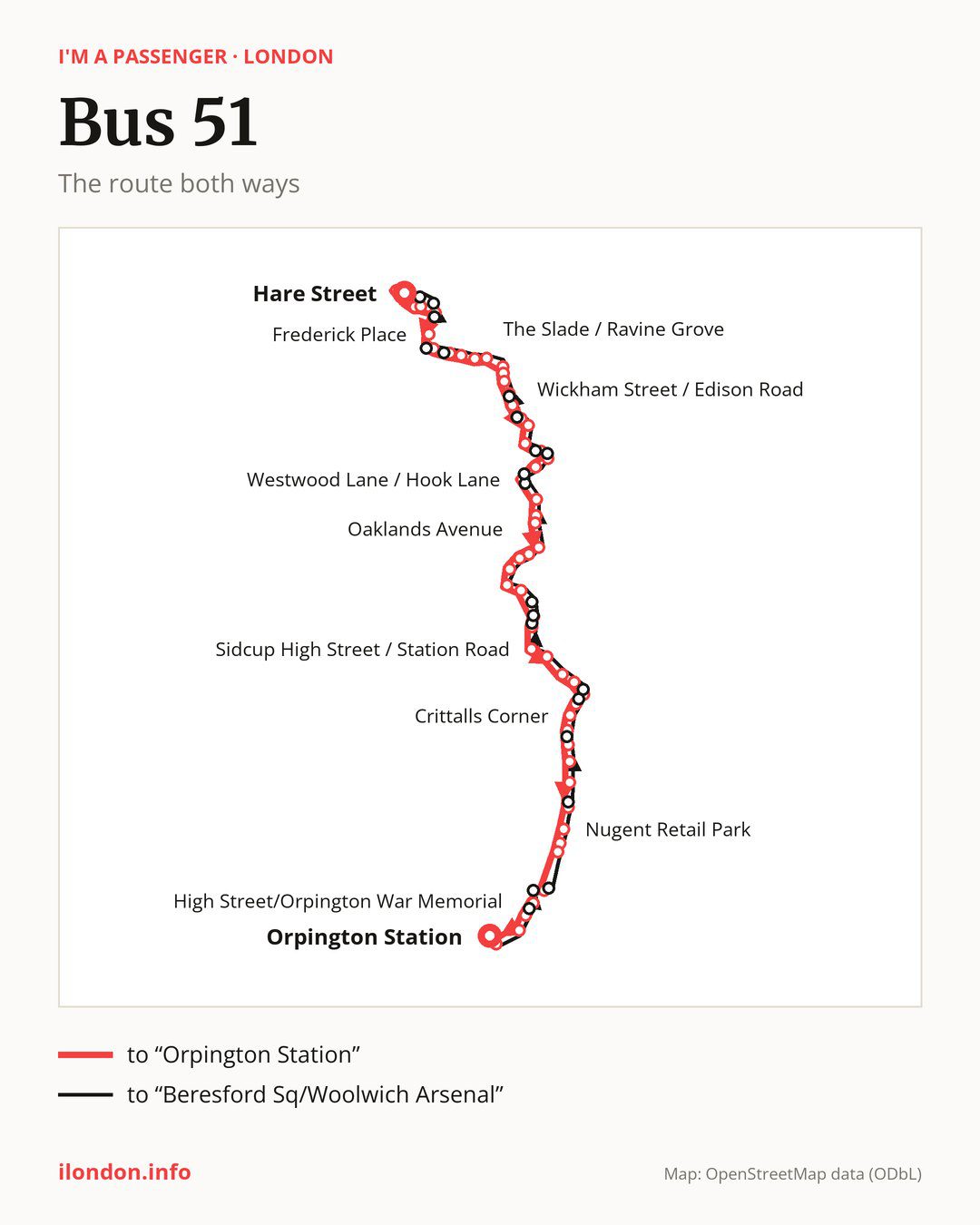
From “Hare Street” to “Orpington Station”: 57 stops. On the way: “Powis Street”, “Calderwood Street”, “Woolwich Arsenal Station”, “Vincent Road/Woolwich Arsenal”, “Burrage Road / Arthur Grove”, “Frederick Place”, “Bloomfield Road / Plumstead Common Road”, “Trinity Church”, “Blendon Terrace”, “Plumstead Common / The Ship”. Then “Plumstead Common Road”, “The Slade / Ravine Grove”, “Bassant Street”, “Kingsdale Road”, “Thornhill Avenue”, “Combeside”, “Chaucer Road (DA16)”, “Wickham Street / Edison Road”, “Central Avenue/ Wickham Street”, “Welling Station”. Then “Deepdene Road”, “Hook Lane / St Leonards Close”, “Faraday Road (DA16)”, “Westwood Lane / Hook Lane”, “Wendover Way”, “Westwood Lane / Blackfen Road”, “Wellington Avenue/Blackfen Rd”, “The Oval”, “Marlborough Park Avenue”, “Oaklands Avenue”. Then “Annandale Road”, “Hollies Avenue”, “Halfway St/Old Farm Road West”, “Sidcup Station”, “Station Road / Crescent Road”, “Sidcup High Street / Station Road”, “Church Road (DA14)”, “Knoll Road”, “Middleton Avenue (DA14)”, “Cray Rd / Foots Cray High St”. Then “Mayfield Villas”, “Crittalls Corner”, “Kemnal Technology College”, “Midfield Way”, “Walsingham Road (BR5)”, “Broomwood Road St Paul’s Cray”, “Station Approach / St Mary Cray”, “Nugent Retail Park”, “Stanley Way”, “Kent Road”. Before “Orpington Station”: “High Street / Carlton Parade”, “High Street / Church Hill”, “Walnuts Centre”, “High Street/Orpington War Memorial”, “Tubbenden Lane”.
On the way back the bus takes a different route, from “Orpington Station” to “Beresford Sq/Woolwich Arsenal” (54 stops). Only in this direction does it call at “High Street / Broomhill Road”, “Goodmead Road”, “Carlton Parade”, “Springvale Way”, “Sevenoaks Way / Midfield Way”, “Suffolk Road (DA14)”, “Sidcup Hill / Cray Road”, “Crescent Road (DA15)”, “Sidcup Station / Station Road”, “Old Farm Avenue”, “Bradenham Avenue”, “Hook Lane / Westwood Lane”, “Bellegrove Rd / Churchfield Rd”, “Ruskin Drive”, “Peregrine Court”, “The Glenmore Arms”, “Kirk Lane”, “Herbert Road (SE18)” and “Burrage Road”. Only in the direction of “Orpington Station” does it call at, among others, “Powis Street”, “Calderwood Street”, “Woolwich Arsenal Station”, “Vincent Road/Woolwich Arsenal”, “Burrage Road / Arthur Grove” and “Bloomfield Road / Plumstead Common Road”. For the way back, board nearby: “Calderwood Street” → “Beresford Sq/Woolwich Arsenal” (300 m), “Woolwich Arsenal Station” → “Beresford Sq/Woolwich Arsenal” (250 m), “Vincent Road/Woolwich Arsenal” → “Beresford Sq/Woolwich Arsenal” (200 m) and “Burrage Road / Arthur Grove” → “Burrage Road” (200 m). Towards “Orpington Station”, board nearby: “High Street / Broomhill Road” → “High Street / Church Hill” (150 m), “Goodmead Road” → “High Street / Carlton Parade” (250 m), “Carlton Parade” → “High Street / Carlton Parade” (100 m) and “Springvale Way” → “Station Approach / St Mary Cray” (100 m).
Left column runs down, right column runs up. Filled stops are served both ways, dashed ones only one way: 24 towards “Orpington Station” and 22 the other way. Tap a stop to see its name.
Where to change
Shared sections with other routes: between “Nugent Retail Park” and “Orpington Station” it shares the road with route R1; between “Woolwich Arsenal Station” and “Plumstead Common / The Ship” it shares the road with route 53; between “Hare Street” and “Bloomfield Road / Plumstead Common Road” it shares the road with route 386.
Connections by stop, in route order:
- “Hare Street”: buses 54, 96, 99, 161, 177, 178, 180, 291, 301, 380 and 422
- “Powis Street” (only towards “Orpington Station”): buses 99, 161, 177, 178, 180 and 291
- “Calderwood Street” (only towards “Orpington Station”): buses 54, 96, 99, 122, 161, 177, 178, 180, 244, 291, 301, 380, 422 and 469
- “Woolwich Arsenal Station” (only towards “Orpington Station”): buses 54, 96, 99, 122, 161, 177, 178, 180, 244, 291, 301, 380, 422, 469 and SL11
- “Vincent Road/Woolwich Arsenal” (only towards “Orpington Station”): buses 54, 96, 99, 122, 161, 177, 178, 180, 244, 291, 301, 380, 422, 469 and SL11
- “Burrage Road / Arthur Grove” (only towards “Orpington Station”): buses 54, 96, 99, 122, 161, 177, 180, 244, 291, 301, 380, 422, 469 and SL11
- “Frederick Place”: buses 122, 161, 178, 244, 291 and 469
- “Bloomfield Road / Plumstead Common Road” (only towards “Orpington Station”): bus 244
- “Trinity Church”: bus 244
- “Blendon Terrace” (only towards “Orpington Station”): bus 291
- Stops from “Plumstead Common / The Ship” to “Thornhill Avenue”: bus 291
- “Welling Station”: buses 89, 486, B15 and B16
- “Deepdene Road” (only towards “Orpington Station”): buses 89, 96, 486, B15 and B16
- “Hook Lane / St Leonards Close” (only towards “Orpington Station”): buses 89, 96, 486, B15 and B16
- “Faraday Road (DA16)”: buses 89, 486, B15 and B16
- “Westwood Lane / Hook Lane” (only towards “Orpington Station”): bus B16
- “Westwood Lane / Blackfen Road” (only towards “Orpington Station”): bus 132
- “Wellington Avenue/Blackfen Rd”: buses 132 and B13
- “The Oval”: bus B13
- “Marlborough Park Avenue”: bus B13
- “Annandale Road”: bus 286
- “Hollies Avenue”: bus 286
- “Halfway St/Old Farm Road West”: buses 229 and 286
- “Sidcup Station” (only towards “Orpington Station”): buses 160, 229, 233, 269, 286, 492 and SL3
- “Station Road / Crescent Road” (only towards “Orpington Station”): buses 160, 229, 233, 269, 286, 492 and SL3
- “Sidcup High Street / Station Road”: buses 160, 229, 233, 269, 286, 492, B14 and SL3
- “Church Road (DA14)”: buses 233, 492 and B14
- “Knoll Road”: buses 233 and 492
- “Middleton Avenue (DA14)”: buses 233 and 492
- “Cray Rd / Foots Cray High St” (only towards “Orpington Station”): buses 233 and 492
- “Mayfield Villas” (only towards “Orpington Station”): buses 233 and 492
- “Crittalls Corner”: bus B14
- “Kemnal Technology College” (only towards “Orpington Station”): bus B14
- “Midfield Way” (only towards “Orpington Station”): bus B14
- “Walsingham Road (BR5)”: bus B14
- “Broomwood Road St Paul’s Cray”: bus R4
- “Station Approach / St Mary Cray”: buses 273, B14 and R4
- “Nugent Retail Park”: buses 273, 477, B14 and R4
- “Stanley Way” (only towards “Orpington Station”): buses 273, 477, B14, R3 and R4
- “Kent Road”: buses 273, 477, B14, R3 and R4
- “High Street / Carlton Parade” (only towards “Orpington Station”): buses 208, 353, 477, B14, R3 and R4
- “High Street / Church Hill” (only towards “Orpington Station”): buses 208, 353, 477, B14, R3 and R4
- “Walnuts Centre”: buses 208, 353, 358, 477, B14, R2, R3, R4, R5, R7, R8, R9 and R10
- “High Street/Orpington War Memorial”: buses 208, 353, 358, 477, B14, R2, R3, R4, R5, R7, R8, R9 and R10
- Stops from “Tubbenden Lane” to “Orpington Bus Station”: buses 208, 353, 358, B14, R2, R3, R4, R5, R7, R8, R9 and R10
- “High Street / Broomhill Road” (only towards “Beresford Sq/Woolwich Arsenal”): buses 208, 353, 358, 477, B14, R2, R3, R4, R5, R7, R8, R9 and R10
- “Goodmead Road” (only towards “Beresford Sq/Woolwich Arsenal”): buses 208, 353, 477, B14, R3 and R4
- “Carlton Parade” (only towards “Beresford Sq/Woolwich Arsenal”): buses 208, 353, 477, B14, R3 and R4
- “Springvale Way” (only towards “Beresford Sq/Woolwich Arsenal”): buses B14 and R4
- “Sevenoaks Way / Midfield Way” (only towards “Beresford Sq/Woolwich Arsenal”): bus B14
- “Suffolk Road (DA14)” (only towards “Beresford Sq/Woolwich Arsenal”): buses 233 and 492
- “Sidcup Hill / Cray Road” (only towards “Beresford Sq/Woolwich Arsenal”): buses 233 and 492
- “Crescent Road (DA15)” (only towards “Beresford Sq/Woolwich Arsenal”): buses 160, 229, 233, 269, 286 and 492
- “Sidcup Station / Station Road” (only towards “Beresford Sq/Woolwich Arsenal”): buses 160, 229, 233, 269, 286, 492 and SL3
- “Old Farm Avenue” (only towards “Beresford Sq/Woolwich Arsenal”): buses 160, 229, 233, 269, 286, 492 and SL3
- “Bradenham Avenue” (only towards “Beresford Sq/Woolwich Arsenal”): bus B16
- “Hook Lane / Westwood Lane” (only towards “Beresford Sq/Woolwich Arsenal”): bus B16
- “Bellegrove Rd / Churchfield Rd” (only towards “Beresford Sq/Woolwich Arsenal”): buses 89, 96, 486, B15 and B16
- “Ruskin Drive” (only towards “Beresford Sq/Woolwich Arsenal”): buses 89, 96, 486, B15 and B16
- “Kirk Lane” (only towards “Beresford Sq/Woolwich Arsenal”): bus 291
- “Herbert Road (SE18)” (only towards “Beresford Sq/Woolwich Arsenal”): bus 244
- “Burrage Road” (only towards “Beresford Sq/Woolwich Arsenal”): buses 54, 96, 99, 122, 161, 177, 180, 244, 291, 301, 380, 422, 469 and SL11
- “Beresford Sq/Woolwich Arsenal”: buses 54, 96, 99, 122, 161, 177, 178, 180, 244, 291, 301, 380, 422, 469 and SL11
Pages for these routes: bus B13, bus B14, bus B15, bus B16, bus R1, bus R10, bus R2, bus R3, bus R4, bus R5, bus R7, bus R8, bus R9, bus SL11, bus SL3, bus 54.
Passes and concessions
Our page “How to pay for public transport in London” describes tickets, passes and concessions, including any differences between modes of transport.
Questions about bus 51
Does bus 51 go to “Frederick Place”?
Yes, in both directions.
Where can I change from bus 51 to another bus route?
Most routes stop at “Woolwich Arsenal Station” (only towards “Orpington Station”; 54, 96, 99, 122, 161, 177, 178, 180, 244, 291, 301, 380, 422, 469 and SL11) and “Vincent Road/Woolwich Arsenal” (only towards “Orpington Station”; 54, 96, 99, 122, 161, 177, 178, 180, 244, 291, 301, 380, 422, 469 and SL11). All other stops with connections are listed above.
Checked on 2 October 2026. Source of the route and stops: Transport for London (TfL).