
Bus route 229 in London runs between “Thamesmead Town Centre” and “Queen Mary’s Hospital / Chislehurst Road”.
Which way bus 229 runs
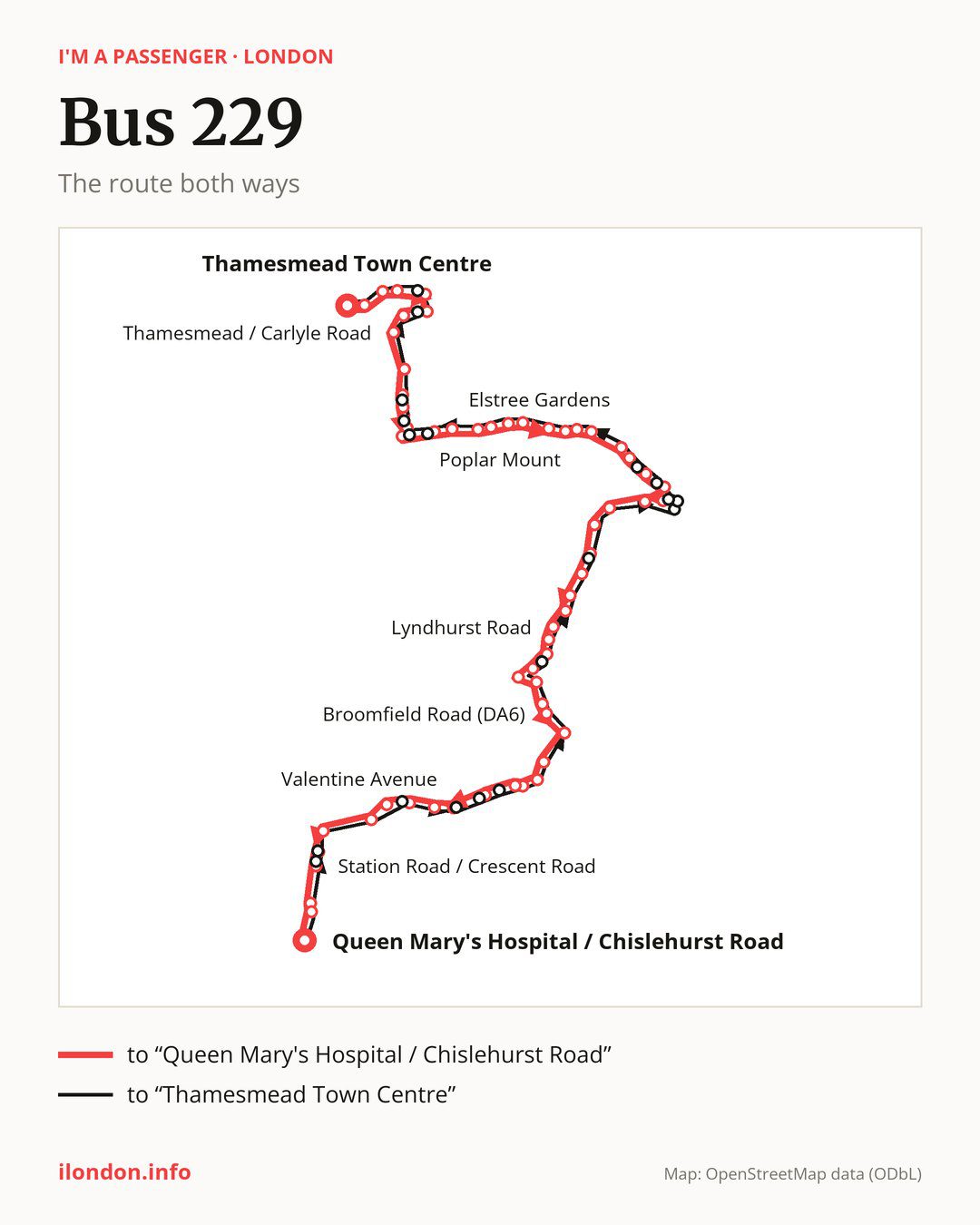
From “Thamesmead Town Centre” to “Queen Mary’s Hospital / Chislehurst Road”: 60 stops. On the way: “Linton Mead Primary School”, “Hoveton Road”, “Nickleby Close”, “Thamesmead North / Eastgate Close”, “Lister Walk”, “Poplar Place”, “Thamesmead / Carlyle Road”, “Southmere Lake”, “Harrow Manorway / Yarnton Way”, “Overton Road”. Then “Harrow Manorway / Abbey Wood Station”, “Abbey Wood Road”, “Lesnes Abbey”, “Elstree Gardens”, “Tunstock Way”, “Kingswood Avenue”, “St. Augustines Road”, “Gilbert Road”, “Lower Road / Belvedere Station”, “Halt Robin Lane”. Then “Poplar Mount”, “Mayfield Road (DA17)”, “Lower Road / Church Manorway”, “St Francis Road”, “Winifred Road / The Ship”, “Erith Station / West Street”, “Erith Town Centre / Cross Street”, “Fraser Road (DA8)”, “Lesney Park”, “Carlton Road”. Then “Northumberland Park / Bexley Road”, “Brook Street (DA8)”, “Rydal Drive”, “Barnehurst Station”, “Lyndhurst Road”, “Long Lane (DA3)”, “Bexleyheath Bus Garage”, “Tower Road”, “Bexleyheath Clock Tower”, “Bexleyheath / Highland Road”. Then “Halcot Avenue”, “Broomfield Road (DA6)”, “Gravel Hill Close”, “Hartford Road”, “Bexley Library”, “Bexley”, “Bexley War Memorial”, “Woodstock Close”, “Valentine Avenue”, “Carisbrooke Avenue”. Before “Queen Mary’s Hospital / Chislehurst Road”: “Crofton Avenue”, “Penhill Road”, “Hurstmere School”, “Sidcup Leisure Centre”, “Sidcup Station”, “Station Road / Crescent Road”, “Sidcup / Carlton Road”, “The Green Sidcup”.
On the way back the bus takes a different route, from “Queen Mary’s Hospital / Chislehurst Road” to “Thamesmead Town Centre” (65 stops). Only in this direction does it call at “Queen Mary’s Hospital Sidcup”, “Crescent Road (DA15)”, “Sidcup Station / Station Road”, “Eynsford Crescent”, “Hurst Springs”, “Grange Wood”, “Parkwood Road Bexley”, “Foresters Crescent”, “Bexley Road Northumberland Heath”, “Erith Health Centre”, “Colebrook Street”, “Erith Town Centre / Riverside”, “Erith High Street”, “Maxim Road / The Ship”, “Fossington Road”, “Abbey Wood / Florence Road”, “Abbey Wood Station”, “Harrow Manorway / Lensbury Way”, “Curlew Close” and “Thamesmead North / Manordene Road”. Only in the direction of “Queen Mary’s Hospital / Chislehurst Road” does it call at, among others, “Thamesmead North / Eastgate Close”, “Harrow Manorway / Yarnton Way”, “Overton Road”, “Harrow Manorway / Abbey Wood Station”, “Elstree Gardens” and “Winifred Road / The Ship”. For the way back, board nearby: “Thamesmead North / Eastgate Close” → “Thamesmead North / Manordene Road” (150 m), “Harrow Manorway / Yarnton Way” → “Harrow Manorway / Lensbury Way” (100 m), “Overton Road” → “Harrow Manorway / Lensbury Way” (100 m) and “Harrow Manorway / Abbey Wood Station” → “Abbey Wood / Florence Road” (100 m). Towards “Queen Mary’s Hospital / Chislehurst Road”, board nearby: “Queen Mary’s Hospital Sidcup” → “Queen Mary’s Hospital / Chislehurst Road” (50 m), “Crescent Road (DA15)” → “Station Road / Crescent Road” (50 m), “Sidcup Station / Station Road” → “Sidcup Station” (50 m) and “Eynsford Crescent” → “Crofton Avenue” (100 m).
Left column runs down, right column runs up. Filled stops are served both ways, dashed ones only one way: 16 towards “Queen Mary's Hospital / Chislehurst Road” and 21 the other way. Tap a stop to see its name.
Connections
Shared sections with other routes: between “Bexleyheath Clock Tower” and “Bexley War Memorial” it shares the road with route 132; between “Thamesmead Town Centre” and “Southmere Lake” it shares the road with routes 177 and 401; between “Brook Street (DA8)” and “Bexleyheath Clock Tower” it shares the road with route 89.
Connections by stop, in route order:
- “Thamesmead Town Centre”: buses 244, 301, SL3 and SL11
- “Linton Mead Primary School”: buses 244, 301, SL3 and SL11
- “Hoveton Road”: bus SL11
- “Nickleby Close”: bus SL11
- “Thamesmead North / Eastgate Close” (only towards “Queen Mary’s Hospital / Chislehurst Road”): bus SL11
- “Lister Walk”: bus SL11
- “Poplar Place”: buses 244, 301, SL3 and SL11
- “Thamesmead / Carlyle Road”: buses 244, 301, SL3 and SL11
- “Southmere Lake”: buses 180, 244, 301 and B11
- “Harrow Manorway / Yarnton Way” (only towards “Queen Mary’s Hospital / Chislehurst Road”): buses 180, 244, 301 and B11
- “Overton Road” (only towards “Queen Mary’s Hospital / Chislehurst Road”): buses 180, 244, 301, B11, SL3 and SL11
- “Harrow Manorway / Abbey Wood Station” (only towards “Queen Mary’s Hospital / Chislehurst Road”): buses 180, 244, 301, B11, SL3 and SL11
- “Abbey Wood Road”: buses 180, 244, 301, B11, SL3 and SL11
- “Lesnes Abbey”: buses 301 and B11
- “Elstree Gardens” (only towards “Queen Mary’s Hospital / Chislehurst Road”): bus B11
- “St. Augustines Road”: bus 180
- “Lower Road / Church Manorway”: bus 180
- “St Francis Road”: bus 180
- “Winifred Road / The Ship” (only towards “Queen Mary’s Hospital / Chislehurst Road”): buses 99 and 180
- “Erith Station / West Street” (only towards “Queen Mary’s Hospital / Chislehurst Road”): buses 99, 180, 428 and B12
- “Erith Town Centre / Cross Street” (only towards “Queen Mary’s Hospital / Chislehurst Road”): buses 99, 180, 428 and B12
- “Fraser Road (DA8)”: buses 99, 180, 428 and B12
- “Lesney Park”: buses 99, 180 and B12
- “Carlton Road”: bus B12
- “Northumberland Park / Bexley Road”: bus B12
- “Barnehurst Station”: bus 99
- “Long Lane (DA3)”: buses 99, 301, B11 and B16
- “Bexleyheath Bus Garage”: buses 99, B11 and B16
- “Tower Road” (only towards “Queen Mary’s Hospital / Chislehurst Road”): buses 96, 99, 269, 301, 422, 486, B11, B12, B15 and B16
- “Bexleyheath Clock Tower”: buses 96, 99, 269, 301, 422, 486, B11, B12, B13, B14, B15, B16 and SL3
- “Bexleyheath / Highland Road”: buses 96, 99, 269, 301, 422, 486, B11, B12, B15 and B16
- “Halcot Avenue”: buses 96 and B12
- Stops from “Broomfield Road (DA6)” to “Hartford Road”: bus B12
- “Bexley Library”: buses 269 and B12
- “Bexley”: buses 269 and B12
- “Bexley War Memorial” (only towards “Queen Mary’s Hospital / Chislehurst Road”): buses 269 and B12
- “Woodstock Close” (only towards “Queen Mary’s Hospital / Chislehurst Road”): bus 269
- “Valentine Avenue” (only towards “Queen Mary’s Hospital / Chislehurst Road”): bus 269
- “Carisbrooke Avenue”: bus 269
- “Crofton Avenue”: buses 269 and B14
- “Penhill Road” (only towards “Queen Mary’s Hospital / Chislehurst Road”): buses 269 and B14
- “Hurstmere School”: buses 269 and B14
- “Sidcup Leisure Centre”: buses 51, 160, 233, 269, 286 and SL3
- “Sidcup Station” (only towards “Queen Mary’s Hospital / Chislehurst Road”): buses 51, 160, 233, 269, 286 and SL3
- “Station Road / Crescent Road” (only towards “Queen Mary’s Hospital / Chislehurst Road”): buses 51, 160, 233, 269, 286 and SL3
- “Sidcup / Carlton Road”: buses 51, 160, 233, 269, 286, 321, B14, R11 and SL3
- “The Green Sidcup”: buses 51, 160, 233, 269, 286, 321, B14, R11 and SL3
- “Queen Mary’s Hospital / Chislehurst Road”: buses 160, 269, 286, B14, R11 and SL3
- “Sidcup / Queen Mary’s Hospital”: buses 160, 269, 286, B14, R11 and SL3
- “Queen Mary’s Hospital Sidcup” (only towards “Thamesmead Town Centre”): buses 160, 269, 286, B14, R11 and SL3
- “Crescent Road (DA15)” (only towards “Thamesmead Town Centre”): buses 51, 160, 233, 269, 286 and SL3
- “Sidcup Station / Station Road” (only towards “Thamesmead Town Centre”): buses 51, 160, 233, 269, 286 and SL3
- “Eynsford Crescent” (only towards “Thamesmead Town Centre”): buses 269 and B14
- Stops from “Hurst Springs” to “Parkwood Road Bexley” (only towards “Thamesmead Town Centre”): bus 269
- “Foresters Crescent” (only towards “Thamesmead Town Centre”): buses 96, 99, 301, B11, B12 and B16
- Stops from “Erith Health Centre” to “Erith High Street” (only towards “Thamesmead Town Centre”): buses 99, 180, 428 and B12
- “Maxim Road / The Ship” (only towards “Thamesmead Town Centre”): bus 180
- Stops from “Fossington Road” to “Harrow Manorway / Lensbury Way” (only towards “Thamesmead Town Centre”): buses 180, 244, 301, B11, SL3 and SL11
- “Curlew Close” (only towards “Thamesmead Town Centre”): bus SL11
- “Thamesmead North / Manordene Road” (only towards “Thamesmead Town Centre”): bus SL11
Pages for these routes: bus B11, bus B12, bus B13, bus B14, bus B15, bus B16, bus R11, bus SL11, bus SL3, bus 51, bus 89, bus 96, bus 99, bus 132, bus 160, bus 177, bus 180.
Passes and concessions
Our page “How to pay for public transport in London” describes tickets, passes and concessions, including any differences between modes of transport.
Questions about bus 229
Does bus 229 go to “Poplar Place”?
Yes, in both directions.
Where can I change from bus 229 to another bus route?
Most routes stop at “Tower Road” (only towards “Queen Mary’s Hospital / Chislehurst Road”; 96, 99, 269, 301, 422, 486, B11, B12, B15 and B16) and “Bexleyheath Clock Tower” (96, 99, 269, 301, 422, 486, B11, B12, B13, B14, B15, B16 and SL3). All other stops with connections are listed above.
Checked on 24 September 2026. Source of the route and stops: Transport for London (TfL).