
Bus route B16 in London links “Bexleyheath Bus Garage” and “Wingfield School”.
Which way bus B16 runs
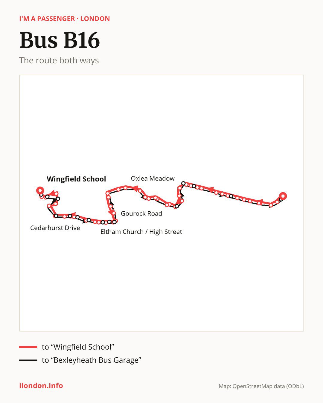
From “Bexleyheath Bus Garage” to “Wingfield School”: 47 stops. On the way: “Tower Road”, “Bexleyheath Clock Tower”, “Trinity Place”, “Bexleyheath / Lion Road”, “Upton Road Bexleyheath”, “Crook Log / Dallin Road”, “Park View Road / Crook Log”, “Bethel Road”, “Guy Earl Of Warwick”, “Welling High St/UpperWickhamLn”. Then “Bellegrove Rd / Churchfield Rd”, “Ruskin Drive”, “Ruskin Avenue / Welling Station”, “Darwin Road”, “Cambridge Avenue (DA16)”, “Yorkland Avenue”, “The Green Welling”, “Falconwood Community Centre”, “Buckingham Avenue (DA16)”, “Northumberland Avenue Falconwood”. Then “Millbrook Avenue”, “Falconwood Station”, “Rochester Way / Falconwood Stn”, “Rochester Way / Welling Way”, “Oxlea Meadow”, “Rochester Way / Glenesk Road”, “Westmount Road / Rochester Way”, “Eltham Park Methodist Church”, “Eltham Park Gardens”, “Gourock Road”. Then “Westmount Road / Eltham High Street”, “Eltham High Street / Foots Cray Road”, “Eltham High Street / St Mary’s Place”, “Eltham High Street / Passey Place”, “Eltham Church / High Street”, “Kingsground”, “Greenway (SE9)”, “Eltham Hill / Middle Park Avenue”, “Eltham Road / Westhorne Avenue”, “Cedarhurst Drive”. Before “Wingfield School”: “Kidbrooke Park Road / Tudway Road”, “Tudway Road / Sutcliffe Park”, “Kidbrooke Station / Tudway Road”, “Weigall Road / South Side”, “Moorehead Way / Weigall Road”.
On the way back the bus takes a different route, from “Wingfield School” to “Bexleyheath Bus Garage” (43 stops). Only in this direction does it call at “Moorehead Way / Pinto Way”, “Weigall Road / North Side”, “Gerrard Way”, “Sutcliffe Park”, “Eltham Hill / Westhorne Avenue”, “Vandyke Cross”, “Sherard Road”, “Eltham High Street / Roper Street”, “Eltham High Street / Pound Place”, “Eltham High Street / Westmount Road”, “Cumberland Avenue Falconwood”, “Central Avenue / Welling Station”, “Deepdene Road”, “Crook Log Leisure Centre” and “Foresters Crescent”. Only in the direction of “Wingfield School” does it call at, among others, “Tower Road”, “Park View Road / Crook Log”, “Bellegrove Rd / Churchfield Rd”, “Ruskin Drive”, “Ruskin Avenue / Welling Station” and “Cambridge Avenue (DA16)”. For the way back, board nearby: “Tower Road” → “Foresters Crescent” (150 m), “Park View Road / Crook Log” → “Crook Log Leisure Centre” (100 m), “Bellegrove Rd / Churchfield Rd” → “Deepdene Road” (150 m) and “Ruskin Drive” → “Deepdene Road” (100 m). Towards “Wingfield School”, board nearby: “Moorehead Way / Pinto Way” → “Moorehead Way / Weigall Road” (100 m), “Weigall Road / North Side” → “Weigall Road / South Side” (50 m), “Gerrard Way” → “Kidbrooke Station / Tudway Road” (200 m) and “Sutcliffe Park” → “Cedarhurst Drive” (50 m).
Left column runs down, right column runs up. Filled stops are served both ways, dashed ones only one way: 19 towards “Wingfield School” and 15 the other way. Tap a stop to see its name.
Other routes along the way
Shared sections with other routes: between “Bexleyheath Bus Garage” and “Ruskin Avenue / Welling Station” it shares the road with route 89; between “Bexleyheath Clock Tower” and “Ruskin Avenue / Welling Station” it shares the road with route 486; between “Bexleyheath Clock Tower” and “Welling High St/UpperWickhamLn” it shares the road with route 96.
Connections by stop, in route order:
- “Bexleyheath Bus Garage”: buses 99, 229 and 492
- “Tower Road” (only towards “Wingfield School”): buses 99, 132, 229, 269, 301, 401, 422, 492 and B12
- “Bexleyheath Clock Tower”: buses 99, 132, 229, 269, 301, 401, 422, 492, B12, B13, B14 and SL3
- “Trinity Place”: buses 269, 401, 422, B12, B13, B14 and SL3
- “Bexleyheath / Lion Road”: buses 269, 422, B12, B14 and SL3
- “Upton Road Bexleyheath”: buses 422, B12, B14 and SL3
- “Crook Log / Dallin Road”: buses 422, B12 and B14
- “Park View Road / Crook Log” (only towards “Wingfield School”): bus B14
- “Bethel Road”: bus B14
- “Welling High St/UpperWickhamLn”: bus 51
- Stops from “Bellegrove Rd / Churchfield Rd” to “Ruskin Avenue / Welling Station” (only towards “Wingfield School”): bus 51
- “Darwin Road”: bus 51
- “Cambridge Avenue (DA16)” (only towards “Wingfield School”): bus 51
- “Yorkland Avenue”: bus 51
- “Gourock Road”: buses 124, 126, 132, 160, 162, 233, 286 and 314
- Stops from “Westmount Road / Eltham High Street” to “Eltham High Street / St Mary’s Place” (only towards “Wingfield School”): buses 124, 126, 132, 160, 162, 233, 286 and 314
- “Eltham High Street / Passey Place” (only towards “Wingfield School”): buses 124, 126, 132, 160, 161, 162, 233, 286 and 314
- “Eltham Church / High Street” (only towards “Wingfield School”): buses 124, 126, 132, 160, 161, 162, 233, 286 and 314
- “Kingsground”: buses 124 and 160
- “Greenway (SE9)” (only towards “Wingfield School”): buses 122 and 160
- “Eltham Hill / Middle Park Avenue” (only towards “Wingfield School”): buses 122 and 160
- “Eltham Road / Westhorne Avenue”: buses 122 and 160
- “Cedarhurst Drive” (only towards “Wingfield School”): buses 122, 160 and 178
- “Kidbrooke Park Road / Tudway Road”: buses 122, 178 and 335
- Stops from “Tudway Road / Sutcliffe Park” to “Moorehead Way / Weigall Road” (only towards “Wingfield School”): buses 178 and 335
- “Wingfield School”: buses 178 and 335
- Stops from “Moorehead Way / Pinto Way” to “Gerrard Way” (only towards “Bexleyheath Bus Garage”): buses 178 and 335
- “Sutcliffe Park” (only towards “Bexleyheath Bus Garage”): buses 122, 160 and 178
- “Eltham Hill / Westhorne Avenue” (only towards “Bexleyheath Bus Garage”): buses 122 and 160
- “Vandyke Cross” (only towards “Bexleyheath Bus Garage”): bus 122
- “Sherard Road” (only towards “Bexleyheath Bus Garage”): buses 124, 126, 132, 160, 161, 162, 233, 286 and 314
- “Eltham High Street / Roper Street” (only towards “Bexleyheath Bus Garage”): buses 124, 126, 132, 160, 161, 162, 233, 286 and 314
- “Eltham High Street / Pound Place” (only towards “Bexleyheath Bus Garage”): buses 124, 126, 132, 160, 162, 233, 286 and 314
- “Eltham High Street / Westmount Road” (only towards “Bexleyheath Bus Garage”): buses 124, 126, 132, 160, 162, 233, 286 and 314
- Stops from “Cumberland Avenue Falconwood” to “Deepdene Road” (only towards “Bexleyheath Bus Garage”): bus 51
- “Crook Log Leisure Centre” (only towards “Bexleyheath Bus Garage”): bus B14
- “Foresters Crescent” (only towards “Bexleyheath Bus Garage”): buses 99, 132, 229, 301, 492 and B12
Pages for these routes: bus B12, bus B14.
Passes and concessions
Which passes are available and who travels free is explained on a separate page: how to pay for public transport in London.
Questions about bus B16
Does bus B16 go to “Trinity Place”?
Yes, in both directions.
Where can I change from bus B16 to another bus route?
Most routes stop at “Tower Road” (only towards “Wingfield School”; 99, 132, 229, 269, 301, 401, 422, 492 and B12) and “Bexleyheath Clock Tower” (99, 132, 229, 269, 301, 401, 422, 492, B12, B13, B14 and SL3). All other stops with connections are listed above.
Checked on 6 October 2026. Source of the route and stops: Transport for London (TfL).