
Bus route 492 in London goes from “Sidcup Station” to “Bus Station”.
Where bus 492 goes
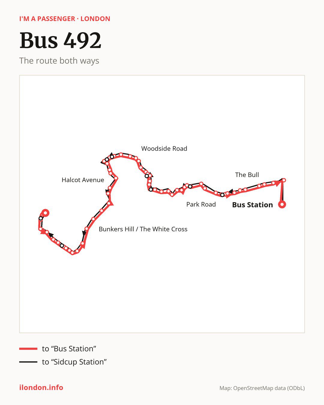
From “Sidcup Station” to “Bus Station”: 60 stops. On the way: “Hatherley Crescent / Sidcup Station”, “Station Road / Crescent Road”, “Sidcup High Street / Station Road”, “Church Road (DA14)”, “Knoll Road”, “Middleton Avenue (DA14)”, “Rectory Lane”, “Five Arches Business Estate”, “Palm Avenue”, “Ruxley Corner”. Then “Barton Road”, “Ellenborough Road”, “Parsonage Lane/ North Cray Church”, “Bunkers Hill / The White Cross”, “Mount Mascal Farm”, “North Cray Road/Vicarage Road”, “Bexley Library”, “Hartford Road”, “Gravel Hill Close”, “Broomfield Road (DA6)”. Then “Halcot Avenue”, “Bexleyheath / Highland Road”, “Bexleyheath Clock Tower”, “Foresters Crescent”, “Mayplace Road East / Pinnacle Hill”, “Mayplace Road East / Barnehurst Road”, “Mayplace Road East / Manor Way”, “Woodside Road”, “Manor Road / Manor Close”, “Old Road / Perry Street”. Then “Crayford High Street”, “Crayford Bridge”, “Crayford Town Hall”, “Crayford Station”, “Royston Road”, “Station Road / Chastilian Road”, “James Road”, “Marcus Road”, “Princes Road”, “Havelock Road South”. Then “Somerset Road”, “Dartford Girls’ Grammar School”, “Dartford Boys’ Grammar School”, “West Hill”, “Priory Hill”, “Home Gardens”, “Hanau Bridge”, “Livingstone Hospital”, “Park Road”, “The Brent”. Before “Bus Station”: “Brentfield Road”, “Milestone Road”, “The Brent School”, “The Welsh Tavern”, “Elm Road”, “The Bull”, “Winston Close”, “Waterstone Park”.
The return journey is different. Towards “Sidcup Station”: 58 stops. Only in this direction does it call at, among others, “St Vincents Road”, “Constance Grove”, “Chastilian Road / Station Road”, “Crayford Bridge Sainsbury’s”, “Erith Road” and “Tower Road”. Only in the direction of “Bus Station” does it call at, among others, “Hatherley Crescent / Sidcup Station”, “Station Road / Crescent Road”, “Rectory Lane”, “Palm Avenue”, “Foresters Crescent” and “Crayford Bridge”. For the way back, board nearby: “Hatherley Crescent / Sidcup Station” → “Sidcup Station” (150 m), “Station Road / Crescent Road” → “Crescent Road (DA15)” (50 m), “Rectory Lane” → “Sidcup Hill / Cray Road” (100 m) and “Palm Avenue” → “Ruxley Corner” (200 m). Towards “Bus Station”, board nearby: “St Vincents Road” → “Park Road” (50 m), “Constance Grove” → “Priory Hill” (50 m), “Chastilian Road / Station Road” → “Station Road / Chastilian Road” (50 m) and “Crayford Bridge Sainsbury’s” → “Crayford Bridge” (100 m).
Left column runs down, right column runs up. Filled stops are served both ways, dashed ones only one way: 10 towards “Bus Station” and 8 the other way. Tap a stop to see its name.
Connections
Shared sections with other routes: between “Station Road / Crescent Road” and “Ruxley Corner” it shares the road with route 233; between “Bexley Library” and “Foresters Crescent” it shares the road with route 229; between “Bexley Library” and “Bexleyheath Clock Tower” it shares the road with route B12.
Connections by stop, in route order:
- “Sidcup Station”: buses 160, 269, 286 and SL3
- “Hatherley Crescent / Sidcup Station” (only towards “Bus Station”): buses 160, 269, 286 and SL3
- “Station Road / Crescent Road” (only towards “Bus Station”): buses 160, 269, 286 and SL3
- “Sidcup High Street / Station Road”: buses 160, 269, 286, 321, B14, R11 and SL3
- “Church Road (DA14)”: buses 321, B14 and R11
- “Knoll Road”: buses 321 and R11
- “Middleton Avenue (DA14)”: buses 321 and R11
- “Rectory Lane” (only towards “Bus Station”): buses 321 and R11
- “Five Arches Business Estate”: buses 321 and R11
- “Bexley Library”: bus 269
- “Bexleyheath / Highland Road”: buses 89, 99, 269, 301, 401, 422, 486, B11, B15 and B16
- “Bexleyheath Clock Tower”: buses 89, 99, 269, 301, 401, 422, 486, B11, B13, B14, B15, B16 and SL3
- “Foresters Crescent” (only towards “Bus Station”): buses 89, 99, 301, B11 and B16
- “Mayplace Road East / Pinnacle Hill”: buses 89, 99, B11 and B16
- “Mayplace Road East / Barnehurst Road”: bus 99
- “Mayplace Road East / Manor Way”: bus 99
- “Crayford High Street”: bus 428
- “Crayford Bridge” (only towards “Bus Station”): bus 428
- “Crayford Town Hall”: bus 428
- “Crayford Station”: bus 428
- Stops from “Somerset Road” to “West Hill”: bus 428
- “Priory Hill” (only towards “Bus Station”): buses 428 and 429
- “Home Gardens”: buses 428, 429 and 477
- “Hanau Bridge” (only towards “Bus Station”): buses 428, 429 and 477
- “Bus Station”: bus 428
- “Constance Grove” (only towards “Sidcup Station”): buses 428 and 429
- “Crayford Bridge Sainsbury’s” (only towards “Sidcup Station”): bus 428
- “Erith Road” (only towards “Sidcup Station”): buses 89, 99, B11 and B16
- “Tower Road” (only towards “Sidcup Station”): buses 89, 99, 269, 301, 401, 422, 486, B11, B15 and B16
- “Sidcup Hill / Cray Road” (only towards “Sidcup Station”): buses 321 and R11
- “Crescent Road (DA15)” (only towards “Sidcup Station”): buses 160, 269, 286 and SL3
Pages for these routes: bus B11, bus B12, bus B13, bus B14, bus B15, bus B16, bus R11, bus SL3, bus 89, bus 99, bus 160, bus 229, bus 233, bus 269, bus 286, bus 301, bus 321, bus 401, bus 422, bus 428, bus 429, bus 477, bus 486.
Passes and concessions
Which passes are available and who travels free is explained on a separate page: how to pay for public transport in London.
Questions about bus 492
Does bus 492 go to “Sidcup High Street / Station Road”?
Yes, in both directions.
Where can I change from bus 492 to another bus route?
Most routes stop at “Bexleyheath / Highland Road” (89, 99, 269, 301, 401, 422, 486, B11, B15 and B16) and “Bexleyheath Clock Tower” (89, 99, 269, 301, 401, 422, 486, B11, B13, B14, B15, B16 and SL3). All other stops with connections are listed above.
Checked on 5 October 2026. Source of the route and stops: Transport for London (TfL).