
Bus route 321 in London links “Foots Cray Tesco” and “New Cross Gate Sainsbury’s”.
Where bus 321 goes
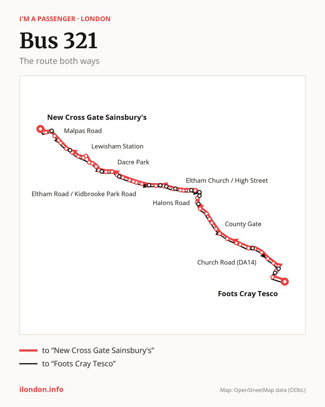
Towards “New Cross Gate Sainsbury’s”: 53 stops. After “Foots Cray Tesco”, the bus calls at “Crittalls Corner”, “Suffolk Road (DA14)”, “Sidcup Hill / Cray Road”, “Middleton Avenue (DA14)”, “Knoll Road”, “Church Road (DA14)”, “Sidcup High Street / Station Road”, “Christchurch Road (DA15)”, “Sydney Road Sidcup”, “Northcote Road (DA14)”. Then “Marechal Niel Parade”, “County Gate”, “Thaxted Road”, “Footscray Road / Southwood Rd”, “New Eltham Stn/Footscray Road”, “Footscray Rugby Club”, “Green Lane (SE9)”, “Halons Road”, “Footscray Road / Southend Crescent”, “Southend Crescent/Southend Clo”. Then “Eltham High Street / Foots Cray Road”, “Eltham High Street / St Mary’s Place”, “Eltham High Street / Passey Place”, “Eltham Church / High Street”, “Kingsground”, “Greenway (SE9)”, “Eltham Hill / Middle Park Avenue”, “Eltham Road / Westhorne Avenue”, “Cedarhurst Drive”, “Eltham Road / Kidbrooke Park Road”. Then “Courtlands Avenue (SE12)”, “Weigall Road”, “Cambridge Drive”, “Lee Green”, “Lampmead Road”, “Dacre Park”, “Brandram Road”, “Belmont Park”, “Marischal Road”, “Belmont Hill”. Then “Lewisham Clock Tower”, “Lewisham Station”, “Lewisham Station / Loampit Vale”, “Loampit Vale / Jerrard Street”, “Undercliff Road”, “Lewisham College / Ashmead School”, “Lucas Street”, “Malpas Road”, “Amersham Road”, “Marquis of Granby / Goldsmiths”. Before “New Cross Gate Sainsbury’s”: “New Cross Gate Station”.
On the way back the bus takes a different route, from “New Cross Gate Sainsbury’s” to “Foots Cray Tesco” (52 stops). Only in this direction does it call at “Marquis Of Granby”, “Tyrwhitt Road/St Johns Station”, “Manor Park”, “Lee Green/The Old Tigers Head”, “Sutcliffe Park”, “Eltham Hill / Westhorne Avenue”, “Vandyke Cross”, “Sherard Road”, “Eltham High Street / Pound Place”, “Southend Crescent / Wythens Walk”, “Holy Trinity Church”, “Inca Drive”, “Main Road / Station Road”, “Cray Rd / Foots Cray High St” and “Mayfield Villas”. Only in the direction of “New Cross Gate Sainsbury’s” does it call at, among others, “Suffolk Road (DA14)”, “Sidcup Hill / Cray Road”, “Footscray Road / Southwood Rd”, “Footscray Road / Southend Crescent”, “Southend Crescent/Southend Clo” and “Eltham High Street / Foots Cray Road”. For the way back, board nearby: “Suffolk Road (DA14)” → “Mayfield Villas” (100 m), “Sidcup Hill / Cray Road” → “Cray Rd / Foots Cray High St” (100 m), “Footscray Road / Southwood Rd” → “New Eltham Stn/Footscray Road” (200 m) and “Footscray Road / Southend Crescent” → “Holy Trinity Church” (150 m). Towards “New Cross Gate Sainsbury’s”, board nearby: “Marquis Of Granby” → “Marquis of Granby / Goldsmiths” (50 m), “Tyrwhitt Road/St Johns Station” → “Undercliff Road” (150 m), “Manor Park” → “Belmont Park” (150 m) and “Lee Green/The Old Tigers Head” → “Lampmead Road” (100 m).
Left column runs down, right column runs up. Filled stops are served both ways, dashed ones only one way: 16 towards “New Cross Gate Sainsbury's” and 15 the other way. Tap a stop to see its name.
Where to change
On part of the route, between “Eltham Road / Westhorne Avenue” and “Belmont Hill” it shares the road with route 122; between “Eltham Road / Kidbrooke Park Road” and “Lewisham Station” it shares the road with route 178; between “Lewisham Clock Tower” and “New Cross Gate Station” it shares the road with routes 21, 136 and 436.
Connections by stop, in route order:
- “Crittalls Corner”: buses 51, B14 and R11
- “Suffolk Road (DA14)” (only towards “New Cross Gate Sainsbury’s”): buses 51, 233, 492 and R11
- “Sidcup Hill / Cray Road” (only towards “New Cross Gate Sainsbury’s”): buses 51, 233, 492 and R11
- “Middleton Avenue (DA14)”: buses 51, 233, 492 and R11
- “Knoll Road”: buses 51, 233, 492 and R11
- “Church Road (DA14)”: buses 51, 233, 492, B14 and R11
- “Sidcup High Street / Station Road”: buses 51, 229, 233, 269, 286, 492, B14, R11 and SL3
- “Christchurch Road (DA15)”: buses 51, 229, 233, 269, 286, 492, B14, R11 and SL3
- “Northcote Road (DA14)”: bus 233
- “Marechal Niel Parade”: bus 233
- “County Gate”: buses 162 and 233
- “Thaxted Road”: buses 162, 233, 314 and B13
- “Footscray Road / Southwood Rd” (only towards “New Cross Gate Sainsbury’s”): buses 162, 233, 314 and B13
- “New Eltham Stn/Footscray Road”: buses 162, 233, 314 and B13
- “Footscray Rugby Club”: buses 233, 314 and B13
- “Green Lane (SE9)”: buses 233, 314 and B13
- “Halons Road”: buses 124, 126, 233, 314 and B13
- “Footscray Road / Southend Crescent” (only towards “New Cross Gate Sainsbury’s”): buses 124, 126, 233 and 314
- Stops from “Southend Crescent/Southend Clo” to “Eltham High Street / St Mary’s Place” (only towards “New Cross Gate Sainsbury’s”): buses 124, 126, 132, 162, 233, 286, 314, B15 and B16
- “Eltham High Street / Passey Place”: buses 124, 126, 132, 161, 162, 233, 286, 314, B15 and B16
- “Eltham Church / High Street” (only towards “New Cross Gate Sainsbury’s”): buses 124, 126, 132, 161, 162, 233, 286, 314, B15 and B16
- “Kingsground”: buses 124, B15 and B16
- “Greenway (SE9)” (only towards “New Cross Gate Sainsbury’s”): buses B15 and B16
- “Eltham Hill / Middle Park Avenue” (only towards “New Cross Gate Sainsbury’s”): buses B15 and B16
- “Eltham Road / Westhorne Avenue”: buses B15 and B16
- “Cedarhurst Drive” (only towards “New Cross Gate Sainsbury’s”): buses B15 and B16
- “Eltham Road / Kidbrooke Park Road”: bus B16
- “Courtlands Avenue (SE12)”: bus B16
- “Cambridge Drive”: buses 202, 261 and SL4
- “Lee Green” (only towards “New Cross Gate Sainsbury’s”): buses 202, 261 and SL4
- “Lampmead Road”: buses 202, 261 and SL4
- “Dacre Park”: buses 202, 261 and SL4
- “Brandram Road”: buses 261 and 273
- “Belmont Park”: buses 54, 89, 108, 261 and 273
- “Marischal Road” (only towards “New Cross Gate Sainsbury’s”): buses 54, 89, 108, 261 and 273
- “Belmont Hill”: buses 47, 54, 75, 89, 108, 129, 181, 185, 199, 208, 225, 261, 273, 284, 380, 484, BL1 and P4
- “Lewisham Clock Tower” (only towards “New Cross Gate Sainsbury’s”): buses 47, 54, 75, 89, 108, 129, 181, 185, 199, 208, 225, 261, 273, 284, 380, 484, BL1 and P4
- “Lewisham Station”: buses 47, 54, 75, 89, 108, 129, 181, 185, 199, 208, 225, 261, 273, 284, 380, 484, BL1 and P4
- “Lewisham Station / Loampit Vale” (only towards “New Cross Gate Sainsbury’s”): buses 47, 75, 89, 108, 129, 181, 185, 199, 208, 225, 261, 273, 284, 380, 484, BL1 and P4
- “Loampit Vale / Jerrard Street”: buses 47, 75, 89, 108, 181, 185, 208, 225, 261, 284, 484, BL1 and P4
- “Undercliff Road”: buses 47 and 225
- “Lucas Street”: buses 171 and 172
- “Malpas Road”: buses 171 and 172
- “Amersham Road”: buses 53, 171, 172, 177, 225 and 453
- “Marquis of Granby / Goldsmiths” (only towards “New Cross Gate Sainsbury’s”): buses 53, 171, 172, 177, 225, 453 and BL1
- “New Cross Gate Station”: buses 36, 53, 171, 172, 177, 225, 343, 453, BL1 and P13
- “New Cross Gate Sainsbury’s”: buses 36, 53, 171, 172, 177, 225, 343, 453, BL1 and P13
- “Marquis Of Granby” (only towards “Foots Cray Tesco”): buses 53, 171, 172, 177, 225, 453 and BL1
- “Tyrwhitt Road/St Johns Station” (only towards “Foots Cray Tesco”): buses 47 and 225
- “Manor Park” (only towards “Foots Cray Tesco”): buses 261 and 273
- “Lee Green/The Old Tigers Head” (only towards “Foots Cray Tesco”): buses 202, 261 and SL4
- Stops from “Sutcliffe Park” to “Vandyke Cross” (only towards “Foots Cray Tesco”): buses B15 and B16
- “Sherard Road” (only towards “Foots Cray Tesco”): buses 124, 126, 132, 161, 162, 233, 286, 314, B15 and B16
- Stops from “Eltham High Street / Pound Place” to “Holy Trinity Church” (only towards “Foots Cray Tesco”): buses 124, 126, 132, 162, 233, 286, 314, B15 and B16
- “Inca Drive” (only towards “Foots Cray Tesco”): buses 233, 314 and B13
- “Main Road / Station Road” (only towards “Foots Cray Tesco”): buses 51, 229, 233, 269, 286, 492, B14, R11 and SL3
- “Cray Rd / Foots Cray High St” (only towards “Foots Cray Tesco”): buses 51, 233, 492 and R11
- “Mayfield Villas” (only towards “Foots Cray Tesco”): buses 51, 233, 492 and R11
Pages for these routes: bus B13, bus B14, bus B15, bus B16, bus BL1, bus P13, bus P4, bus R11, bus SL3, bus SL4, bus 21, bus 36, bus 47, bus 51, bus 53, bus 54, bus 75, bus 89, bus 108, bus 122, bus 124, bus 126, bus 129, bus 132, bus 136, bus 161, bus 162, bus 171, bus 172, bus 177, bus 178, bus 181, bus 185, bus 199, bus 202, bus 208, bus 225, bus 229, bus 233, bus 261, bus 269, bus 273, bus 284, bus 286, bus 314.
Passes and concessions
Which passes are available and who travels free is explained on a separate page: how to pay for public transport in London.
Questions about bus 321
Does bus 321 go to “Sidcup High Street / Station Road”?
Yes, in both directions.
Where can I change from bus 321 to another bus route?
Most routes stop at “Belmont Hill” (47, 54, 75, 89, 108, 129, 181, 185, 199, 208, 225, 261, 273, 284, 380, 484, BL1 and P4) and “Lewisham Clock Tower” (only towards “New Cross Gate Sainsbury’s”; 47, 54, 75, 89, 108, 129, 181, 185, 199, 208, 225, 261, 273, 284, 380, 484, BL1 and P4). All other stops with connections are listed above.
Checked on 3 October 2026. Source of the route and stops: Transport for London (TfL).