
Bus route D6 in London goes from “King Edward’s Road” to “Isle of Dogs Asda”. The return journey starts at “Crossharbour Asda” (50 m from “Isle of Dogs Asda”) and ends at “Mare Street / Victoria Park Rd” (250 m from “King Edward’s Road”).
Which way bus D6 runs
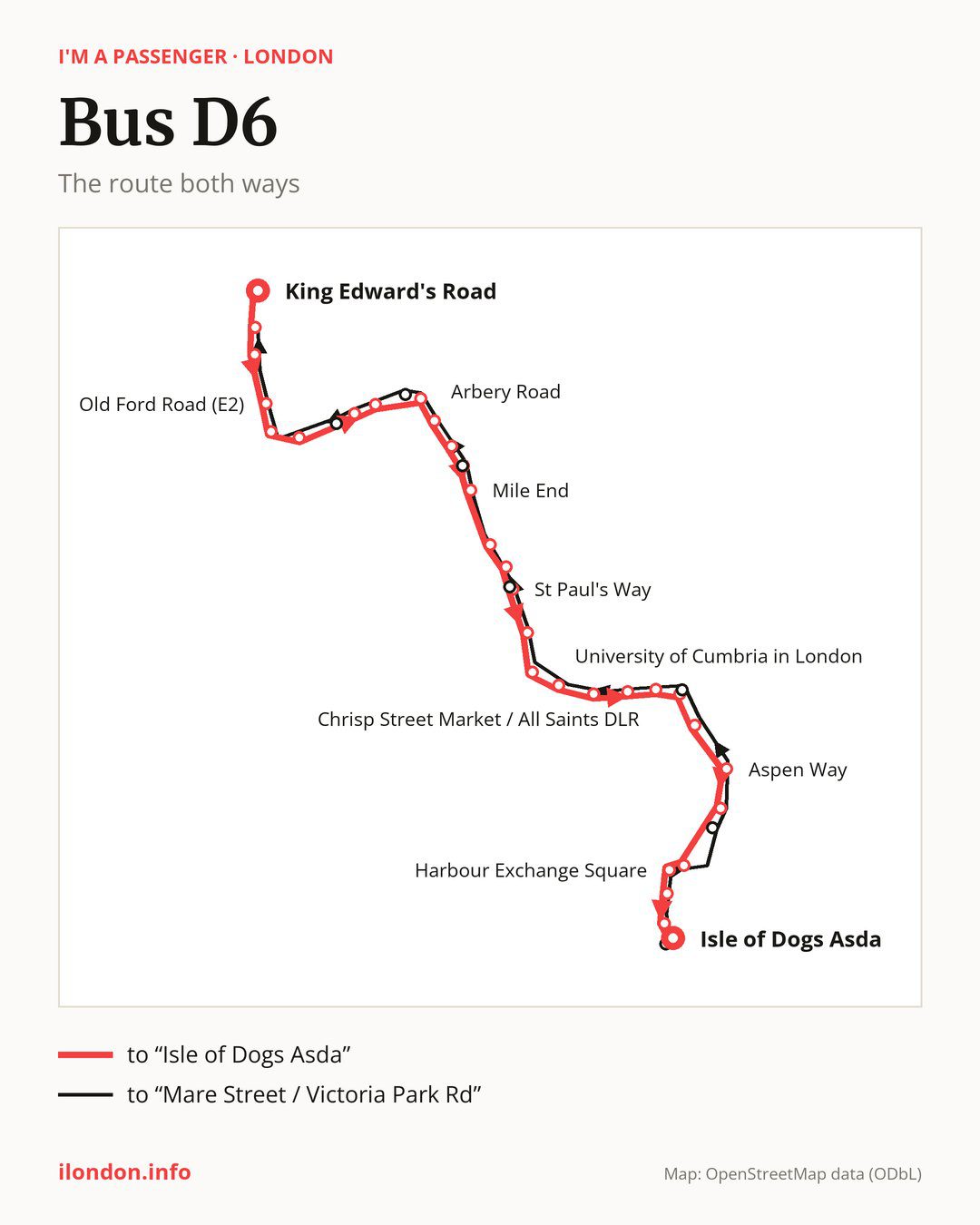
From “King Edward’s Road” to “Isle of Dogs Asda”: 31 stops. On the way: “Mare Street / Victoria Park Rd”, “Cambridge Heath Station”, “Old Ford Road (E2)”, “Bethnal Green”, “Burnham Street”, “Bonner Street”, “Smart Street”, “St Barnabas Church (E3)”, “Arbery Road”, “Lichfield Road”. Then “Mile End Station / Bow Road”, “Mile End”, “Eric Street”, “Mile End Park Leisure Centre”, “St Paul’s Way”, “Pixley Street”, “East India Dock Road / Limehouse”, “University of Cumbria in London”, “Upper North Street”, “Poplar Recreation Ground / DLR”. Before “Isle of Dogs Asda”: “Chrisp Street Market / All Saints DLR”, “Poplar / All Saints Church”, “Poplar High Street / Blackwall”, “Aspen Way”, “Coldharbour”, “Jack Dash House”, “Harbour Exchange Square”, “East Ferry Road Crossharbour”, “Crossharbour”.
On the way back the bus takes a different route, from “Crossharbour Asda” to “Mare Street / Victoria Park Rd” (29 stops). Only in this direction does it call at “The Blue Bridge”, “Bazely Street / All Saints DLR”, “Ackroyd Drive / Burdett Road”, “Mile End Station / Mile End Rd”, “Haverfield Green / Grove Road” and “Morpeth Street”. Only in the direction of “Isle of Dogs Asda” does it call at, among others, “Burnham Street”, “Smart Street”, “Mile End Station / Bow Road”, “Mile End Park Leisure Centre”, “Chrisp Street Market / All Saints DLR” and “Poplar / All Saints Church”. For the way back, board nearby: “Burnham Street” → “Bethnal Green” (200 m), “Smart Street” → “Bonner Street” (150 m), “Mile End Station / Bow Road” → “Mile End Station / Mile End Rd” (50 m) and “Mile End Park Leisure Centre” → “Ackroyd Drive / Burdett Road” (150 m). Towards “Isle of Dogs Asda”, board nearby: “The Blue Bridge” → “Coldharbour” (150 m), “Bazely Street / All Saints DLR” → “Poplar / All Saints Church” (50 m), “Ackroyd Drive / Burdett Road” → “St Paul’s Way” (50 m) and “Mile End Station / Mile End Rd” → “Mile End Station / Bow Road” (50 m).
Left column runs down, right column runs up. Filled stops are served both ways, dashed ones only one way: 9 towards “Isle of Dogs Asda” and 7 the other way. Tap a stop to see its name.
Where to change
Shared sections with other routes: between “St Barnabas Church (E3)” and “East India Dock Road / Limehouse” it shares the road with route 277; between “Mile End Station / Bow Road” and “East India Dock Road / Limehouse” it shares the road with route D7; between “University of Cumbria in London” and “Poplar High Street / Blackwall” it shares the road with route 15.
Connections by stop, in route order:
- “King Edward’s Road”: buses 26, 55, 236, 388 and 394
- “Mare Street / Victoria Park Rd”: buses 26, 55, 388 and 394
- “Cambridge Heath Station”: buses 26, 55, 309, 388, 394 and D3
- “Old Ford Road (E2)”: buses 8, 26, 55, 309, 388 and D3
- “Bethnal Green”: buses 8, 309, 388 and D3
- “Burnham Street” (only towards “Isle of Dogs Asda”): buses 8, 309, 388 and D3
- “Bonner Street”: bus 8
- “Smart Street” (only towards “Isle of Dogs Asda”): buses 8, 339 and 425
- “St Barnabas Church (E3)”: buses 8, 339 and 425
- “Arbery Road”: buses 8, 339 and 425
- “Lichfield Road”: buses 25, 205, 323, 339 and 425
- “Mile End Station / Bow Road” (only towards “Isle of Dogs Asda”): buses 25, 205, 323, 339 and 425
- “Mile End”: buses 25, 205, 323, 339 and 425
- “Eric Street”: buses 309 and 323
- “Mile End Park Leisure Centre” (only towards “Isle of Dogs Asda”): buses 309 and 323
- “St Paul’s Way”: bus 309
- “Pixley Street”: buses 115, 309 and D3
- “East India Dock Road / Limehouse”: buses 115 and D3
- “University of Cumbria in London”: buses 115 and D3
- “Upper North Street”: buses 115 and 309
- “Poplar Recreation Ground / DLR”: buses 108, 115, 309 and D8
- “Chrisp Street Market / All Saints DLR” (only towards “Isle of Dogs Asda”): buses 108, 115, 309 and D8
- “Poplar / All Saints Church” (only towards “Isle of Dogs Asda”): buses 108, 115, 309 and D8
- “Poplar High Street / Blackwall”: buses 108, 115, D3, D8 and SL4
- “Aspen Way”: buses D3, D8 and SL4
- “Jack Dash House”: bus D8
- “Harbour Exchange Square”: bus D8
- “East Ferry Road Crossharbour” (only towards “Isle of Dogs Asda”): bus D8
- Stops from “Crossharbour” to “Crossharbour Asda”: bus D8
- “Bazely Street / All Saints DLR” (only towards “Mare Street / Victoria Park Rd”): buses 108, 115, 309 and D8
- “Ackroyd Drive / Burdett Road” (only towards “Mare Street / Victoria Park Rd”): bus 309
- “Mile End Station / Mile End Rd” (only towards “Mare Street / Victoria Park Rd”): buses 25, 205, 323, 339 and 425
- “Haverfield Green / Grove Road” (only towards “Mare Street / Victoria Park Rd”): buses 8, 339 and 425
- “Morpeth Street” (only towards “Mare Street / Victoria Park Rd”): buses 8, 309 and D3
Pages for these routes: bus D3, bus D7.
Passes and concessions
Our page “How to pay for public transport in London” describes tickets, passes and concessions, including any differences between modes of transport.
Questions about bus D6
Where does bus D6 start its return journey?
At “Crossharbour Asda” (50 m from “Isle of Dogs Asda”).
Where can I change from bus D6 to another bus route?
Most routes stop at “Cambridge Heath Station” (26, 55, 309, 388, 394 and D3) and “Old Ford Road (E2)” (8, 26, 55, 309, 388 and D3). All other stops with connections are listed above.
Checked on 7 October 2026. Source of the route and stops: Transport for London (TfL).