
Bus route 428 in London runs between “Erith Town Centre / Cross Street” and “Bus Station”. The return journey ends at “Erith Town Centre / Riverside” (100 m from “Erith Town Centre / Cross Street”).
The route of bus 428
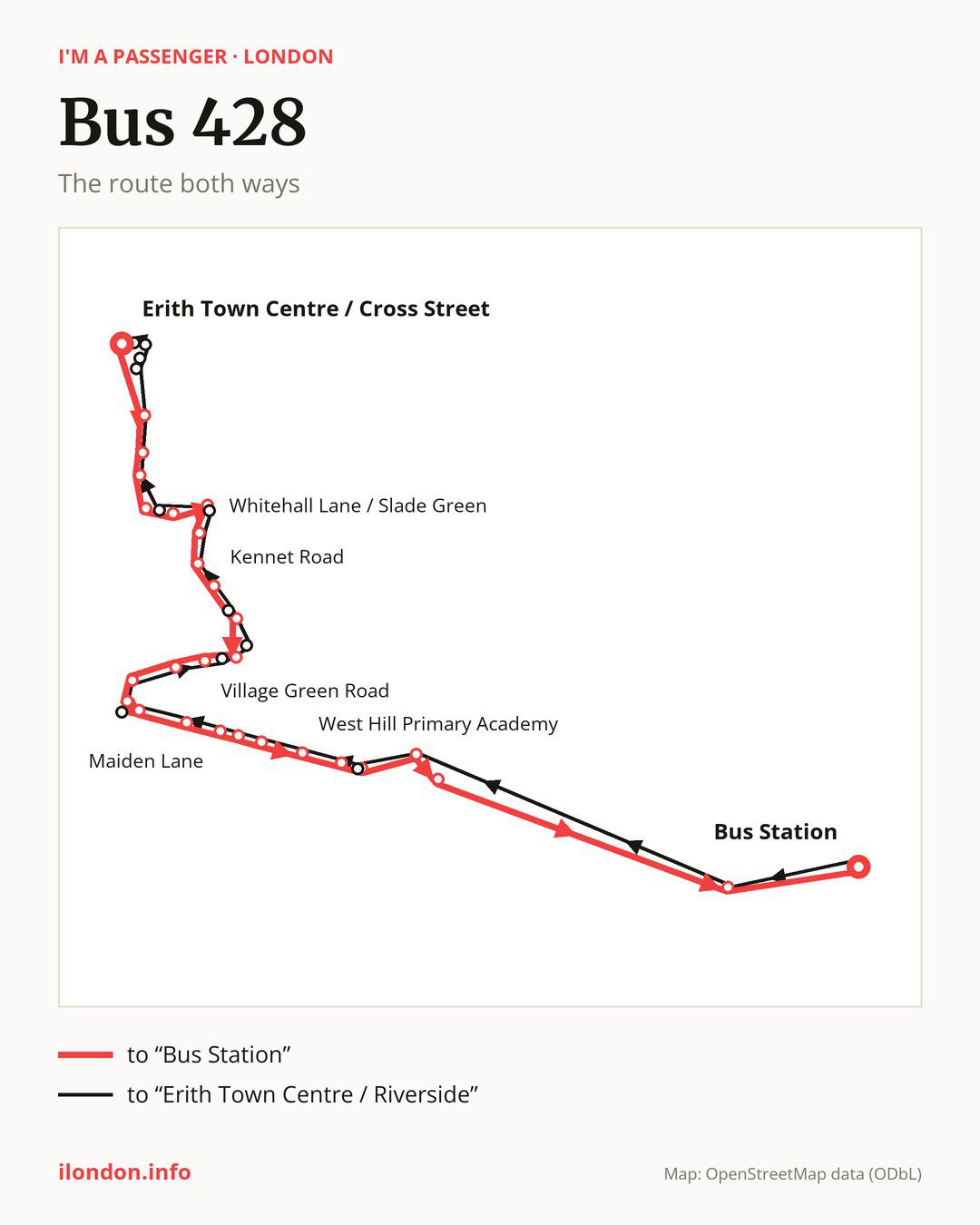
Towards “Bus Station”: 28 stops. After “Erith Town Centre / Cross Street”, the bus calls at “Larner Road”, “Peareswood Road”, “Northend Road / Colyers Lane”, “Bridge Road / Northend Road”, “Dale View”, “Whitehall Lane / Slade Green”, “Lincoln Road”, “Shearwood Crescent”, “Kennet Road”, “Mayplace Avenue”. Then “The Jolly Farmers Open Space”, “Village Green Road”, “The Rise”, “Waterside”, “Crayford Bridge”, “Crayford Town Hall”, “Heath Road (DA1)”, “Maiden Lane”, “Bird In Hand”, “Havelock Road North”. Before “Bus Station”: “West Hill Primary Academy”, “West Hill”, “Priory Hill”, “Home Gardens”, “Hanau Bridge”, “Darent Valley Hospital”.
On the way back the bus takes a different route, from “Bus Station” to “Erith Town Centre / Riverside” (28 stops). Only in this direction does it call at “Constance Grove”, “Crayford Bridge Sainsbury’s”, “Stanham Place”, “Mill Place”, “Medway Road (DA1)”, “Howbury Lane / Slade Green”, “Whitehall Lane / Bridge Road”, “James Watt Way”, “Erith Health Centre” and “Colebrook Street”. Only in the direction of “Bus Station” does it call at, among others, “Peareswood Road”, “Whitehall Lane / Slade Green”, “Kennet Road”, “Mayplace Avenue”, “The Jolly Farmers Open Space” and “The Rise”. For the way back, board nearby: “Peareswood Road” → “Northend Road / Colyers Lane” (200 m), “Whitehall Lane / Slade Green” → “Howbury Lane / Slade Green” (50 m), “Kennet Road” → “Shearwood Crescent” (250 m) and “Mayplace Avenue” → “Medway Road (DA1)” (100 m). Towards “Bus Station”, board nearby: “Constance Grove” → “Priory Hill” (50 m), “Crayford Bridge Sainsbury’s” → “Crayford Bridge” (100 m), “Stanham Place” → “The Jolly Farmers Open Space” (150 m) and “Mill Place” → “The Jolly Farmers Open Space” (150 m).
Left column runs down, right column runs up. Filled stops are served both ways, dashed ones only one way: 11 towards “Bus Station” and 11 the other way. Tap a stop to see its name.
Connections
On part of the route, between “Crayford Bridge” and “Bus Station” it shares the road with route 96; between “West Hill” and “Hanau Bridge” it shares the road with route 492.
Connections by stop, in route order:
- “Erith Town Centre / Cross Street”: buses 99, 180, 229, 469 and B12
- “Peareswood Road” (only towards “Bus Station”): bus 89
- Stops from “Northend Road / Colyers Lane” to “Dale View”: buses 89 and 99
- “Whitehall Lane / Slade Green” (only towards “Bus Station”): buses 89 and 99
- “Lincoln Road”: buses 89 and 99
- “Shearwood Crescent”: bus 99
- “Priory Hill” (only towards “Bus Station”): bus 429
- “Home Gardens”: buses 429 and 477
- “Hanau Bridge” (only towards “Bus Station”): buses 429 and 477
- “Constance Grove” (only towards “Erith Town Centre / Riverside”): bus 429
- “Howbury Lane / Slade Green” (only towards “Erith Town Centre / Riverside”): buses 89 and 99
- “Whitehall Lane / Bridge Road” (only towards “Erith Town Centre / Riverside”): buses 89 and 99
- Stops from “James Watt Way” to “Colebrook Street” (only towards “Erith Town Centre / Riverside”): buses 99, 180, 229, 469 and B12
- “Erith Town Centre / Riverside”: buses 99, 180, 229, 469 and B12
Pages for these routes: bus B12, bus 89, bus 96, bus 99, bus 180, bus 229.
Passes and concessions
Tickets, passes and concessions are covered on a separate page: how to pay for public transport in London.
Questions and answers
Does bus 428 go to “Crayford Town Hall”?
Yes, in both directions.
Where can I change from bus 428 to another bus route?
Most routes stop at “Erith Town Centre / Cross Street” (99, 180, 229, 469 and B12) and “James Watt Way” (only towards “Erith Town Centre / Riverside”; 99, 180, 229, 469 and B12). All other stops with connections are listed above.
Checked on 28 September 2026. Source of the route and stops: Transport for London (TfL).