
Bus route 99 in London links “Woolwich High Street” and “Geddes Place”. In one direction or the other it serves 2 stops that it skips on the way back. The return journey ends at “Beresford Sq/Woolwich Arsenal” (450 m from “Woolwich High Street”).
The route of bus 99
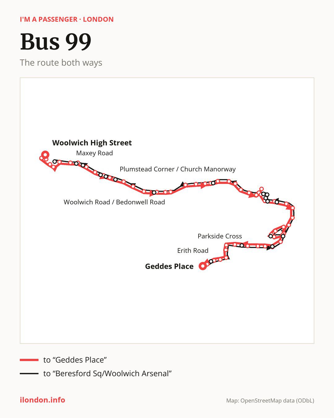
From “Woolwich High Street” to “Geddes Place”: 57 stops. On the way: “Hare Street”, “Powis Street”, “Thomas Street”, “Woolwich Arsenal Station”, “Woolwich Station”, “Maxey Road”, “Plumstead Bus Garage”, “Plumstead High Street / Plumstead Station”, “Lakedale Road”, “Plumstead High Street / Police Station”. Then “Purrett Road”, “Plumstead Corner / Church Manorway”, “Basildon Road”, “Bostall Hill / Bostall Lane”, “Longleigh Lane”, “Woolwich Road / Brampton Road”, “New Road West Heath”, “Woolwich Road / Bedonwell Road”, “The View”, “The Eardley Arms”. Then “Erith Road / Nuxley Road”, “Erith Road / Brook Street”, “Erith Fire Station”, “Trinity School”, “Alford Road”, “Birch Walk”, “Europa Trading Estate”, “Fraser Road / Bexley Road”, “Walnut Tree Road (DA8)”, “Erith Station / West Street”. Then “Erith Town Centre / Cross Street”, “James Watt Way”, “Manor Road / Aperfield Road”, “Bilton Road”, “Slade Green Road / Manor Road”, “Grange Way”, “Hazel Road”, “Forest Rd / Slade Green Stn”, “Forest Road / Bridge Road”, “Masefield Close”. Then “Bridge Lane / Whitehall Lane”, “Dale View”, “Whitehall Lane / Slade Green”, “Lincoln Road”, “Thames Road (DA1)”, “Perry Street”, “Eversley Cross”, “Parkside Cross”, “Northall Road / Manor Way”, “Northall Road / Barnehurst Stn”. Before “Geddes Place”: “Barnehurst Road / Randolph Close”, “Mayplace Road East / Barnehurst Road”, “Mayplace Road East / Pinnacle Hill”, “Erith Road”, “Tower Road”.
On the way back the bus takes a different route, from “Geddes Place” to “Beresford Sq/Woolwich Arsenal” (50 stops). Only in this direction does it call at “Foresters Crescent”, “Parkside Avenue / Manor Way”, “Howbury Lane”, “Howbury Lane / Slade Green”, “Whitehall Lane / Bridge Road”, “Manor Road / Frobisher Road”, “Compton Place”, “Erith Health Centre”, “Colebrook Street”, “Erith Town Centre / Riverside”, “Brook Street (DA17)”, “Bostall Hill / Brampton Road”, “Plumstead Corner/Rockmount Rd”, “Plumstead High Street / The Plumstead Centre”, “Bannockburn Road”, “Plumstead Road / Plumstead Station” and “Greenwich Community College”. Only in the direction of “Geddes Place” does it call at, among others, “Hare Street”, “Powis Street”, “Thomas Street”, “Woolwich Arsenal Station”, “Woolwich Station” and “Plumstead Bus Garage”. For the way back, board nearby: “Hare Street” → “Beresford Sq/Woolwich Arsenal” (350 m), “Thomas Street” → “Beresford Sq/Woolwich Arsenal” (200 m), “Woolwich Arsenal Station” → “Beresford Sq/Woolwich Arsenal” (200 m) and “Woolwich Station” → “Beresford Sq/Woolwich Arsenal” (200 m). Towards “Geddes Place”, board nearby: “Foresters Crescent” → “Erith Road” (100 m), “Parkside Avenue / Manor Way” → “Parkside Cross” (200 m), “Howbury Lane” → “Thames Road (DA1)” (50 m) and “Howbury Lane / Slade Green” → “Whitehall Lane / Slade Green” (50 m).
Left column runs down, right column runs up. Filled stops are served both ways, dashed ones only one way: 26 towards “Geddes Place” and 19 the other way. Tap a stop to see its name.
Other routes along the way
Shared sections with other routes: between “Thomas Street” and “Plumstead Corner / Church Manorway” it shares the road with route 96; between “Woolwich Arsenal Station” and “Plumstead Corner / Church Manorway” it shares the road with route 422; between “Thomas Street” and “Plumstead Bus Garage” it shares the road with routes 177 and 180.
Connections by stop, in route order:
- “Woolwich High Street”: buses 51, 161, 178, 291 and 386
- “Hare Street” (only towards “Geddes Place”): buses 51, 53, 54, 161, 178, 291, 301, 380 and 386
- “Powis Street” (only towards “Geddes Place”): buses 51, 161, 178, 291 and 386
- Stops from “Thomas Street” to “Woolwich Station” (only towards “Geddes Place”): buses 51, 53, 54, 161, 178, 291, 301, 380, 386, 469 and SL11
- “Maxey Road”: buses 51, 53, 54, 161, 291, 301, 380, 386, 469 and SL11
- “Plumstead Bus Garage” (only towards “Geddes Place”): buses 301, 380, 469 and SL11
- “Plumstead High Street / Plumstead Station” (only towards “Geddes Place”): buses 53, 301, 380, 469 and SL11
- “Lakedale Road”: buses 53 and 469
- Stops from “Plumstead High Street / Police Station” to “Plumstead Corner / Church Manorway” (only towards “Geddes Place”): bus 469
- “Basildon Road”: bus 469
- “Woolwich Road / Brampton Road” (only towards “Geddes Place”): buses 301, 469 and B11
- “New Road West Heath”: buses 301, 469 and B11
- “Woolwich Road / Bedonwell Road”: buses 301, 469 and B11
- “The View”: bus 469
- “The Eardley Arms”: buses 401 and 469
- “Erith Road / Nuxley Road”: buses 401 and 469
- “Erith Road / Brook Street” (only towards “Geddes Place”): buses 401 and 469
- “Birch Walk”: bus 229
- “Europa Trading Estate”: buses 229 and B12
- “Fraser Road / Bexley Road”: buses 229, 428, 469 and B12
- Stops from “Walnut Tree Road (DA8)” to “James Watt Way” (only towards “Geddes Place”): buses 229, 428, 469 and B12
- “Manor Road / Aperfield Road” (only towards “Geddes Place”): buses 229, 428 and B12
- “Grange Way”: bus 89
- “Hazel Road”: bus 89
- Stops from “Forest Rd / Slade Green Stn” to “Masefield Close”: buses 89 and 428
- “Bridge Lane / Whitehall Lane” (only towards “Geddes Place”): buses 89 and 428
- “Dale View”: buses 89 and 428
- “Whitehall Lane / Slade Green” (only towards “Geddes Place”): buses 89 and 428
- “Lincoln Road”: buses 89 and 428
- “Thames Road (DA1)” (only towards “Geddes Place”): bus 428
- “Northall Road / Barnehurst Stn”: buses 89 and 229
- “Barnehurst Road / Randolph Close”: bus 492
- “Mayplace Road East / Barnehurst Road”: bus 492
- “Mayplace Road East / Pinnacle Hill”: buses 89, 229, 492, B11 and B16
- “Erith Road” (only towards “Geddes Place”): buses 89, 229, 492, B11 and B16
- “Tower Road” (only towards “Geddes Place”): buses 89, 132, 229, 269, 301, 401, 486, 492, B11, B12, B15 and B16
- “Geddes Place”: buses 89, 132, 229, 269, 301, 401, 486, 492, B11, B12, B13, B14, B15, B16 and SL3
- “Bexleyheath Clock Tower”: buses 89, 132, 229, 269, 301, 401, 486, 492, B11, B12, B13, B14, B15, B16 and SL3
- “Foresters Crescent” (only towards “Beresford Sq/Woolwich Arsenal”): buses 89, 132, 229, 301, 492, B11, B12 and B16
- “Howbury Lane” (only towards “Beresford Sq/Woolwich Arsenal”): bus 428
- “Howbury Lane / Slade Green” (only towards “Beresford Sq/Woolwich Arsenal”): buses 89 and 428
- “Whitehall Lane / Bridge Road” (only towards “Beresford Sq/Woolwich Arsenal”): buses 89 and 428
- Stops from “Compton Place” to “Erith Town Centre / Riverside” (only towards “Beresford Sq/Woolwich Arsenal”): buses 229, 428, 469 and B12
- “Brook Street (DA17)” (only towards “Beresford Sq/Woolwich Arsenal”): buses 401 and 469
- “Bostall Hill / Brampton Road” (only towards “Beresford Sq/Woolwich Arsenal”): buses 301, 469 and B11
- Stops from “Plumstead Corner/Rockmount Rd” to “Bannockburn Road” (only towards “Beresford Sq/Woolwich Arsenal”): bus 469
- “Plumstead Road / Plumstead Station” (only towards “Beresford Sq/Woolwich Arsenal”): buses 53, 301, 380, 469 and SL11
- “Greenwich Community College” (only towards “Beresford Sq/Woolwich Arsenal”): buses 301, 380, 469 and SL11
- “Beresford Sq/Woolwich Arsenal”: buses 51, 53, 54, 161, 178, 291, 301, 380, 386, 469 and SL11
Pages for these routes: bus B11, bus B12, bus B13, bus B14, bus B15, bus B16, bus SL11, bus SL3, bus 51, bus 53, bus 54, bus 89, bus 96, bus 132, bus 161, bus 177, bus 178, bus 180, bus 229, bus 269, bus 291, bus 301, bus 380, bus 386, bus 401, bus 422, bus 428, bus 469, bus 486, bus 492.
Passes and concessions
Which passes are available and who travels free is explained on a separate page: how to pay for public transport in London.
Questions about bus 99
Does bus 99 go to “Erith Fire Station”?
Yes, in both directions.
Where can I change from bus 99 to another bus route?
Most routes stop at “Geddes Place” and “Bexleyheath Clock Tower” (89, 132, 229, 269, 301, 401, 486, 492, B11, B12, B13, B14, B15, B16 and SL3). All other stops with connections are listed above.
Checked on 1 October 2026. Source of the route and stops: Transport for London (TfL).