
Bus route N242 in London goes from “Homerton Hospital / Wardle St” to “St Giles High Street”. This is a night route. The return journey starts at “New Oxford Street” (150 m from “St Giles High Street”) and ends at “Homerton Hospital” (100 m from “Homerton Hospital / Wardle St”).
Which way bus N242 runs
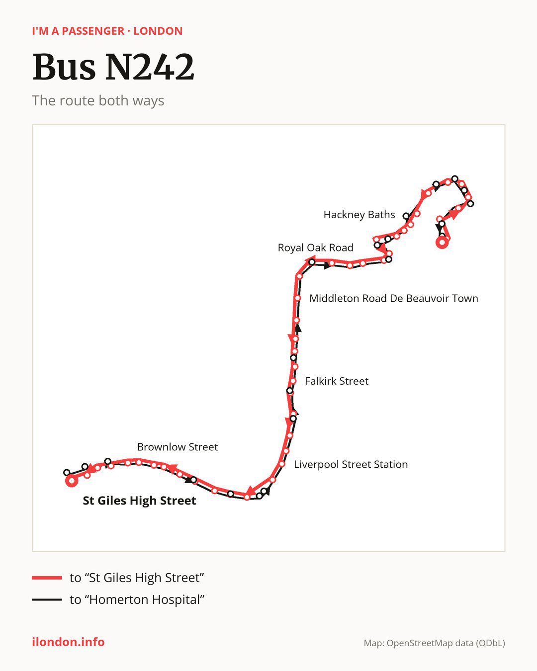
From “Homerton Hospital / Wardle St” to “St Giles High Street”: 45 stops. On the way: “Brooksby’s Walk / Homerton Station”, “Chatsworth Road / Clifden Road”, “Redwald Road”, “Mandeville Street / Gilpin Road”, “Mandeville Primary School”, “Millfields Road”, “Chatsworth Road/Millfields Rd”, “Median Road”, “Lower Clapton Road”, “Hackney Baths”. Then “Clapton Square”, “Pembury Circus”, “Hackney Central Station”, “Graham Road / Hackney Central”, “Royal Oak Road”, “Greenwood Road”, “Stannard Road”, “Dalston Junction Station”, “Forest Road / Kingsland Road”, “Middleton Road De Beauvoir Town”. Then “Haggerston Station/Downham Rd”, “Laburnum Street”, “St Leonards Hospital”, “Hoxton Station / Museum of the Home”, “Falkirk Street”, “Shoreditch Church”, “Shoreditch High Street Station”, “Commercial Street / Worship St”, “Primrose Street”, “Liverpool Street Station”. Then “Camomile Street”, “Bank Station / Cornhill”, “Poultry / Bank Station”, “Bread Street”, “St. Paul’s Station”, “City Thameslink”, “Holborn Circus”, “Holborn Circus / Fetter Lane”, “Chancery Lane”, “Brownlow Street”. Before “St Giles High Street”: “Holborn Station”, “High Holborn”, “Drury Lane”.
On the way back the bus takes a different route, from “New Oxford Street” to “Homerton Hospital” (46 stops). Only in this direction does it call at “Museum Street”, “Procter Street”, “King Edward Street”, “Bank Station / Poultry”, “Bishopsgate City of London”, “Threadneedle Street”, “Shoreditch High St / Bethnal Green Road”, “Waterson Street”, “Pearson Street”, “Dalston Lane/Dalston Junction Station”, “Hackney Central / Mare Street”, “Amhurst Road / Hackney Downs”, “Clarence Road Hackney”, “Powerscroft Road/Lower Clapton Road”, “Millfields Road/Clapton Park”, “Oswald Street”, “Mandeville Street”, “Daubeney Road” and “Brooksby’s Walk”. Only in the direction of “St Giles High Street” does it call at, among others, “Brooksby’s Walk / Homerton Station”, “Chatsworth Road / Clifden Road”, “Mandeville Street / Gilpin Road”, “Mandeville Primary School”, “Millfields Road” and “Median Road”. For the way back, board nearby: “Brooksby’s Walk / Homerton Station” → “Homerton Hospital” (100 m), “Chatsworth Road / Clifden Road” → “Brooksby’s Walk” (100 m), “Mandeville Street / Gilpin Road” → “Daubeney Road” (100 m) and “Mandeville Primary School” → “Mandeville Street” (100 m). Towards “St Giles High Street”, board nearby: “Museum Street” → “Drury Lane” (150 m), “Procter Street” → “Holborn Station” (100 m), “King Edward Street” → “St. Paul’s Station” (50 m) and “Bank Station / Poultry” → “Poultry / Bank Station” (50 m).
Left column runs down, right column runs up. Filled stops are served both ways, dashed ones only one way: 20 towards “St Giles High Street” and 21 the other way. Tap a stop to see its name.
Where to change
Shared sections with other routes: between “Shoreditch High Street Station” and “High Holborn” it shares the road with route N8; between “Bank Station / Cornhill” and “High Holborn” it shares the road with route N25; between “Hackney Baths” and “Dalston Junction Station” it shares the road with route N38.
Connections by stop, in route order:
- “Median Road” (only towards “St Giles High Street”): bus N253
- “Lower Clapton Road” (only towards “St Giles High Street”): bus N253
- “Hackney Baths”: bus N253
- “Clapton Square” (only towards “St Giles High Street”): bus N253
- “Pembury Circus” (only towards “St Giles High Street”): bus N253
- “Hackney Central Station”: bus N253
- “Graham Road / Hackney Central” (only towards “St Giles High Street”): bus N253
- “Royal Oak Road”: bus N253
- “Shoreditch Church”: bus N205
- “Shoreditch High Street Station”: bus N205
- “Commercial Street / Worship St” (only towards “St Giles High Street”): bus N205
- “Primrose Street”: buses N133 and N205
- “Liverpool Street Station”: buses N133, N205 and N551
- “Camomile Street”: buses N133, N205, N550 and N551
- “Bank Station / Cornhill”: buses N15, N21, N133, N199, N550 and N551
- “Poultry / Bank Station” (only towards “St Giles High Street”): buses N15, N21, N199, N550 and N551
- “Bread Street” (only towards “St Giles High Street”): buses N15, N21, N199, N550 and N551
- “St. Paul’s Station”: buses N15, N21, N63, N199, N550 and N551
- “City Thameslink”: buses N15, N21, N63, N89, N199, N550 and N551
- “Holborn Circus”: bus N63
- “Holborn Circus / Fetter Lane”: bus N63
- “Chancery Lane”: buses N19 and N41
- “Brownlow Street”: buses N19, N41 and N98
- “Holborn Station” (only towards “St Giles High Street”): buses N1, N19, N41, N68, N91, N98, N171 and N207
- “High Holborn” (only towards “St Giles High Street”): buses N1, N19, N41, N68, N91, N98, N171 and N207
- “Drury Lane” (only towards “St Giles High Street”): buses N1, N19, N41, N68, N91, N98, N171, N207 and N253
- “St Giles High Street”: buses N1, N5, N19, N20, N29, N41, N68, N73, N98, N171, N207, N253 and N279
- “New Oxford Street”: buses N1, N5, N19, N20, N29, N41, N68, N73, N98, N171, N207, N253 and N279
- “Museum Street” (only towards “Homerton Hospital”): buses N1, N19, N41, N68, N91, N98, N171, N207 and N253
- “Procter Street” (only towards “Homerton Hospital”): buses N1, N19, N41, N68, N91, N98, N171 and N207
- “King Edward Street” (only towards “Homerton Hospital”): buses N15, N21, N63, N199, N550 and N551
- “Bank Station / Poultry” (only towards “Homerton Hospital”): buses N15, N21, N199, N550 and N551
- “Bishopsgate City of London” (only towards “Homerton Hospital”): buses N15, N21, N133, N550 and N551
- “Threadneedle Street” (only towards “Homerton Hospital”): buses N21, N133, N550 and N551
- “Shoreditch High St / Bethnal Green Road” (only towards “Homerton Hospital”): bus N205
- Stops from “Hackney Central / Mare Street” to “Powerscroft Road/Lower Clapton Road” (only towards “Homerton Hospital”): bus N253
Pages for these routes: bus N1, bus N133, bus N15, bus N171, bus N19, bus N199, bus N20, bus N205, bus N207, bus N21, bus N253.
Passes and concessions
Our page “How to pay for public transport in London” describes tickets, passes and concessions, including any differences between modes of transport.
Questions and answers
Where does bus N242 start its return journey?
At “New Oxford Street” (150 m from “St Giles High Street”).
Where can I change from bus N242 to another bus route?
Most routes stop at “St Giles High Street” and “New Oxford Street” (N1, N5, N19, N20, N29, N41, N68, N73, N98, N171, N207, N253 and N279). All other stops with connections are listed above.
Checked on 5 October 2026. Source of the route and stops: Transport for London (TfL).