

Bus route R2 in London runs between “Orpington Police Station” and “East Hill”.
Where bus R2 goes
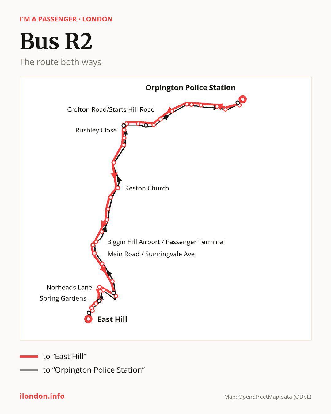
From “Orpington Police Station” to “East Hill”: 35 stops. On the way: “Spur Road / Orpington War Memorial”, “Tubbenden Lane”, “Orpington Station”, “Pound Court Drive”, “Crofton Road / Crofton Lane”, “Oakwood Road / St. Pauls Church”, “Glyndebourne Park”, “Crofton Road/Starts Hill Road”, “Locksbottom / St Michael’s Church”, “Keston Park Close”. Then “Croydon Road / The Keston Mark”, “Rushley Close”, “Rolinsden Way”, “Fishponds Road”, “Westerham Rd / Heathfield Rd”, “Keston Church”, “Blackness Lane”, “Leaves Green / Ashmore Lane”, “Leaves Green / The Kings Arms”, “Biggin Hill Airport / Passenger Terminal”. Then “Hanbury Drive”, “Biggin Hill Memorial Museum”, “Main Road / Salt Box Hill”, “Main Road / Sunningvale Ave”, “Biggin Hill / Black Horse”, “Lebanon Gardens”, “Norheads Lane / Stock Hill”, “Norheads Lane”, “Kings Road Recreation Ground”, “Biggin Hill Valley”. Before “East Hill”: “Kings Road Biggin Hill”, “Spring Gardens”, “Melody Road”.
The return journey is different. Towards “Orpington Police Station”: 36 stops. Only in this direction does it call at, among others, “Hillingdale”, “Rosehill Road”, “Maple Leaf Close”, “Westerham Road / The Keston Mark”, “Locksbottom / Farnborough Cmn” and “High Street/Orpington War Memorial”. Only in the direction of “East Hill” does it call at “Spur Road / Orpington War Memorial”, “Rushley Close”, “Hanbury Drive”, “Norheads Lane”, “Biggin Hill Valley” and “Melody Road”. For the way back, board nearby: “Spur Road / Orpington War Memorial” → “High Street/Orpington War Memorial” (100 m), “Rushley Close” → “Westerham Road / The Keston Mark” (150 m), “Hanbury Drive” → “Biggin Hill Memorial Museum” (150 m) and “Norheads Lane” → “Kings Road Recreation Ground” (150 m). Towards “East Hill”, board nearby: “Hillingdale” → “Melody Road” (150 m), “Rosehill Road” → “Biggin Hill Valley” (50 m), “Maple Leaf Close” → “Lebanon Gardens” (150 m) and “Westerham Road / The Keston Mark” → “Croydon Road / The Keston Mark” (150 m).
Left column runs down, right column runs up. Filled stops are served both ways, dashed ones only one way: 6 towards “East Hill” and 7 the other way. Tap a stop to see its name.
Where to change
Shared sections with other routes: between “Rushley Close” and “Biggin Hill Valley” it shares the road with route 320; between “Tubbenden Lane” and “Croydon Road / The Keston Mark” it shares the road with route 353; between “Tubbenden Lane” and “Locksbottom / St Michael’s Church” it shares the road with route 61.
Connections by stop, in route order:
- “Orpington Police Station”: buses 51, 208, 358, 477, B14, R1, R4, R5, R7, R8, R9, R10 and R11
- “Spur Road / Orpington War Memorial” (only towards “East Hill”): buses 51, 208, 358, 477, B14, R1, R4, R5, R7, R8, R9, R10 and R11
- “Tubbenden Lane”: buses 51, 208, 358, B14, R1, R4, R5, R7, R8, R9 and R10
- “Orpington Station”: buses 51, 208, 358, B14, R1, R4, R5, R7, R8, R9 and R10
- “Pound Court Drive”: buses 208 and R7
- “Crofton Road / Crofton Lane”: bus 208
- “Oakwood Road / St. Pauls Church”: bus 208
- “Crofton Road/Starts Hill Road”: buses 261, 336 and R4
- “Locksbottom / St Michael’s Church”: buses 261, 336, 358 and R4
- “Keston Park Close”: buses 261, 336 and 358
- “Westerham Rd / Heathfield Rd”: bus 146
- “Keston Church”: bus 146
- “Biggin Hill / Black Horse”: bus R8
- “Lebanon Gardens”: bus R8
- “Maple Leaf Close” (only towards “Orpington Police Station”): bus R8
- “Locksbottom / Farnborough Cmn” (only towards “Orpington Police Station”): buses 261, 336, 358 and R4
- “High Street/Orpington War Memorial” (only towards “Orpington Police Station”): buses 51, 208, 358, 477, B14, R1, R4, R5, R7, R8, R9, R10 and R11
- “Walnuts Centre” (only towards “Orpington Police Station”): buses 51, 208, 358, 477, B14, R1, R4, R5, R7, R8, R9, R10 and R11
Pages for these routes: bus B14, bus R1, bus R10, bus R11, bus R4, bus R5, bus R7.
Passes and concessions
Which passes are available and who travels free is explained on a separate page: how to pay for public transport in London.
Questions and answers
Does bus R2 go to “Orpington Station”?
Yes, in both directions.
Where can I change from bus R2 to another bus route?
Most routes stop at “Orpington Police Station” (51, 208, 358, 477, B14, R1, R4, R5, R7, R8, R9, R10 and R11) and “Spur Road / Orpington War Memorial” (only towards “East Hill”; 51, 208, 358, 477, B14, R1, R4, R5, R7, R8, R9, R10 and R11). All other stops with connections are listed above.
Checked on 29 September 2026. Source of the route and stops: Transport for London (TfL).