

Bus route R1 in London links “Grovelands Road” and “High Street / Worlds End Lane”. The return journey starts at “High Street / Green Street Green” (200 m from “High Street / Worlds End Lane”).
Where bus R1 goes
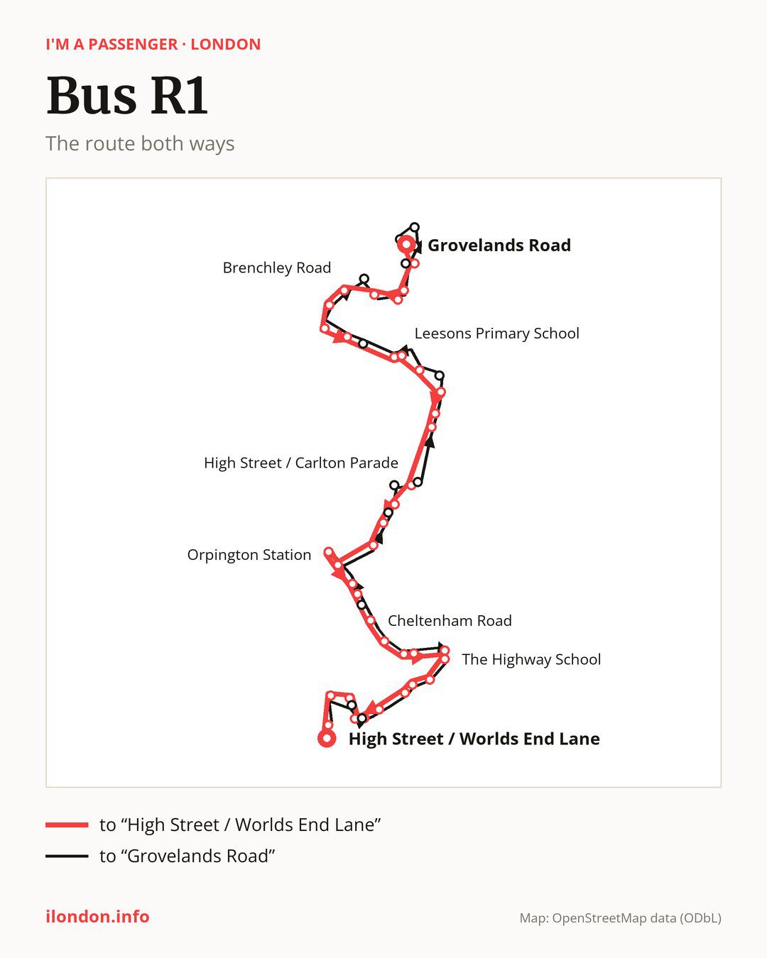
Towards “High Street / Worlds End Lane”: 40 stops. After “Grovelands Road”, the bus calls at “Croxley Green”, “Cotmandene Crescent”, “Goose Green Close”, “Chorleywood Crescent”, “Brenchley Road”, “St Peter And St Paul School”, “Bridgewater Close”, “Marlings Park Avenue”, “Clarendon Way”, “Leesons Primary School”. Then “St Mary Cray Station”, “Nugent Retail Park”, “Stanley Way”, “Kent Road”, “High Street / Carlton Parade”, “High Street / Church Hill”, “Walnuts Centre”, “High Street/Orpington War Memorial”, “Tubbenden Lane”, “Orpington Station”. Then “Orpington Bus Station”, “St Aubyns Gardens”, “Sevenoaks Road”, “Cheltenham Road”, “Sandhurst Road”, “Eton Road / Repton Road”, “Malvern Road (BR6)”, “Winchester Road”, “The Highway School”, “Stirling Drive”. Before “High Street / Worlds End Lane”: “Chelsfield”, “Chelsfield Centre”, “High Beeches (BR6)”, “Woodlands Road Green Street Green”, “Vine Road”, “Highfield Avenue (BR6)”, “Farnborough Hill”, “High Street / Green Street Green”.
On the way back the bus takes a different route, from “High Street / Green Street Green” to “Grovelands Road” (44 stops). Only in this direction does it call at “Waring Drive”, “Windsor Drive/Waring Drive”, “Repton Road / Cranleigh Close”, “High Street / Broomhill Road”, “Goodmead Road”, “Carlton Parade”, “St Mary Cray/Station Approach”, “Manorfields Close”, “Beddington Road”, “Midfield Way / Chipperfield Road”, “Bostall Road”, “Wisley Road” and “Lullingstone Crescent”. Only in the direction of “High Street / Worlds End Lane” does it call at, among others, “Croxley Green”, “Goose Green Close”, “Stanley Way”, “High Street / Carlton Parade”, “High Street / Church Hill” and “Sevenoaks Road”. For the way back, board nearby: “Croxley Green” → “Midfield Way / Chipperfield Road” (100 m), “Goose Green Close” → “Cotmandene Crescent” (150 m), “Stanley Way” → “Kent Road” (200 m) and “High Street / Carlton Parade” → “Carlton Parade” (100 m). Towards “High Street / Worlds End Lane”, board nearby: “Waring Drive” → “Highfield Avenue (BR6)” (100 m), “Windsor Drive/Waring Drive” → “Woodlands Road Green Street Green” (50 m), “Repton Road / Cranleigh Close” → “Sevenoaks Road” (150 m) and “High Street / Broomhill Road” → “High Street / Church Hill” (150 m).
Left column runs down, right column runs up. Filled stops are served both ways, dashed ones only one way: 9 towards “High Street / Worlds End Lane” and 13 the other way. Tap a stop to see its name.
Where to change
On part of the route, between “Nugent Retail Park” and “Orpington Station” it shares the road with route 51; between “Bridgewater Close” and “Kent Road” it shares the road with route 273; between “St Mary Cray Station” and “High Street/Orpington War Memorial” it shares the road with route R11.
Connections by stop, in route order:
- “Grovelands Road”: bus B14
- “Croxley Green” (only towards “High Street / Worlds End Lane”): bus B14
- “Cotmandene Crescent”: bus B14
- “Goose Green Close” (only towards “High Street / Worlds End Lane”): bus B14
- “Chorleywood Crescent”: bus B14
- “Brenchley Road”: bus B14
- Stops from “Clarendon Way” to “St Mary Cray Station”: bus B14
- “Nugent Retail Park”: buses 477 and B14
- “Stanley Way” (only towards “High Street / Worlds End Lane”): buses 477 and B14
- “Kent Road”: buses 477 and B14
- “High Street / Carlton Parade” (only towards “High Street / Worlds End Lane”): buses 208, 353, 477 and B14
- “High Street / Church Hill” (only towards “High Street / Worlds End Lane”): buses 208, 353, 477 and B14
- “Walnuts Centre”: buses 208, 353, 358, 477, B14, R2, R5, R7, R8, R9 and R10
- “High Street/Orpington War Memorial”: buses 208, 353, 358, 477, B14, R2, R5, R7, R8, R9 and R10
- Stops from “Tubbenden Lane” to “St Aubyns Gardens”: buses 208, 353, 358, B14, R2, R5, R7, R8, R9 and R10
- “Sevenoaks Road” (only towards “High Street / Worlds End Lane”): buses 358, R5, R7, R8 and R10
- “Cheltenham Road”: buses 358, R5, R7, R8 and R10
- “Sandhurst Road”: bus R7
- Stops from “Malvern Road (BR6)” to “The Highway School”: bus R7
- “Highfield Avenue (BR6)” (only towards “High Street / Worlds End Lane”): buses 358, R5, R8 and R10
- “Farnborough Hill”: buses 358, R5, R8 and R10
- “High Street / Green Street Green”: buses R5 and R10
- “High Street / Worlds End Lane”: buses R5 and R10
- “Repton Road / Cranleigh Close” (only towards “Grovelands Road”): buses 358, R5, R7, R8 and R10
- “High Street / Broomhill Road” (only towards “Grovelands Road”): buses 208, 353, 358, 477, B14, R2, R5, R7, R8, R9 and R10
- “Goodmead Road” (only towards “Grovelands Road”): buses 208, 353, 477 and B14
- “Carlton Parade” (only towards “Grovelands Road”): buses 208, 353, 477 and B14
- “St Mary Cray/Station Approach” (only towards “Grovelands Road”): bus B14
- Stops from “Beddington Road” to “Bostall Road” (only towards “Grovelands Road”): bus B14
- “Lullingstone Crescent” (only towards “Grovelands Road”): bus B14
Pages for these routes: bus B14, bus R5, bus R7.
Passes and concessions
Which passes are available and who travels free is explained on a separate page: how to pay for public transport in London.
Questions about bus R1
Where does bus R1 start its return journey?
At “High Street / Green Street Green” (200 m from “High Street / Worlds End Lane”).
Where can I change from bus R1 to another bus route?
Most routes stop at “Walnuts Centre” and “High Street/Orpington War Memorial” (208, 353, 358, 477, B14, R2, R5, R7, R8, R9 and R10). All other stops with connections are listed above.
Checked on 27 September 2026. Source of the route and stops: Transport for London (TfL).