
Bus route R4 in London runs between “Augustine Road” and “Princess Royal University Hosp”.
Which way bus R4 runs
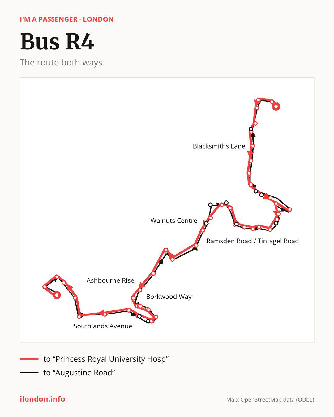
From “Augustine Road” to “Princess Royal University Hosp”: 49 stops. On the way: “Chalk Pit Avenue”, “Main Road”, “The Landway”, “Hearns Road”, “Mill Brook Road”, “Blacksmiths Lane”, “The Temple”, “Reynolds Cross / Red Lion”, “Chelsfield Road”, “Chelsfield Road / Paul’s Cray Hill”. Then “Cockmannings Road”, “Waldenhurst Road”, “Somerden Road”, “Rookesley Road”, “Renton Drive”, “Brow Crescent”, “Ramsden Road”, “Ramsden Road / Tintagel Road”, “Dyke Drive”, “Ramsden Road / Court Road”. Then “Court Road / Green Lane”, “High Street / Carlton Parade”, “High Street / Church Hill”, “Walnuts Centre”, “High Street/Orpington War Memorial”, “Tubbenden Lane”, “Orpington Station”, “Orpington Bus Station”, “Southcroft Road”, “Ashbourne Rise”. Then “Curzon Close”, “Tubbenden Lane Crofton”, “Tubbenden Drive”, “Northlands Avenue”, “Borkwood Way”, “Harley Gardens”, “Oakleigh Gardens Orpington”, “South Drive/ Orpington”, “Haywood Rise”, “Southlands Avenue”. Before “Princess Royal University Hosp”: “Beechcroft Road”, “Farnborough Way”, “Hill Avenue”, “Lovibonds Avenue”, “Starts Hill Road”, “Crofton Road/Starts Hill Road”, “Locksbottom / St Michael’s Church”.
On the way back the bus takes a different route, from “Princess Royal University Hosp” to “Augustine Road” (47 stops). Only in this direction does it call at “Downsway / Southlands Avenue”, “Southlands Drive”, “High Street / Broomhill Road”, “Goodmead Road”, “Carlton Parade”, “Ramsden Road / Kynaston Road”, “Chelsfield Lane”, “Mungo Park Way”, “Northfield Avenue Orpington” and “Station Road (BR5)”. Only in the direction of “Princess Royal University Hosp” does it call at, among others, “Hearns Road”, “Mill Brook Road”, “Chelsfield Road / Paul’s Cray Hill”, “Ramsden Road / Tintagel Road”, “Ramsden Road / Court Road” and “High Street / Carlton Parade”. For the way back, board nearby: “Hearns Road” → “Station Road (BR5)” (150 m), “Mill Brook Road” → “Station Road (BR5)” (50 m), “Chelsfield Road / Paul’s Cray Hill” → “Chelsfield Road” (50 m) and “Ramsden Road / Tintagel Road” → “Ramsden Road” (150 m). Towards “Princess Royal University Hosp”, board nearby: “Downsway / Southlands Avenue” → “Southlands Avenue” (50 m), “Southlands Drive” → “Haywood Rise” (50 m), “High Street / Broomhill Road” → “High Street / Church Hill” (150 m) and “Goodmead Road” → “High Street / Carlton Parade” (250 m).
Left column runs down, right column runs up. Filled stops are served both ways, dashed ones only one way: 12 towards “Princess Royal University Hosp” and 10 the other way. Tap a stop to see its name.
Connections
Shared sections with other routes: between “Ramsden Road / Tintagel Road” and “Orpington Station” it shares the road with route 353; between “High Street / Carlton Parade” and “Orpington Bus Station” it shares the road with route R1; between “High Street / Carlton Parade” and “Orpington Station” it shares the road with routes 51, 61, 208 and R3.
Connections by stop, in route order:
- “Hearns Road” (only towards “Princess Royal University Hosp”): buses 273, B14 and R11
- “Mill Brook Road” (only towards “Princess Royal University Hosp”): buses 273, B14 and R11
- Stops from “Blacksmiths Lane” to “Reynolds Cross / Red Lion”: buses 273, 477, B14 and R11
- “Chelsfield Road”: buses 477 and B14
- “Chelsfield Road / Paul’s Cray Hill” (only towards “Princess Royal University Hosp”): buses 477 and B14
- Stops from “Renton Drive” to “Ramsden Road”: bus R9
- “Ramsden Road / Tintagel Road” (only towards “Princess Royal University Hosp”): bus R9
- “Dyke Drive”: bus R9
- “Court Road / Green Lane”: buses 477, B14 and R11
- “High Street / Carlton Parade” (only towards “Princess Royal University Hosp”): buses 477, B14 and R11
- “High Street / Church Hill” (only towards “Princess Royal University Hosp”): buses 477, B14 and R11
- “Walnuts Centre”: buses 358, 477, B14, R2, R5, R7, R8, R9, R10 and R11
- “High Street/Orpington War Memorial”: buses 358, 477, B14, R2, R5, R7, R8, R9, R10 and R11
- Stops from “Tubbenden Lane” to “Orpington Bus Station”: buses 358, B14, R2, R5, R7, R8, R9 and R10
- “Northlands Avenue”: buses 358, R5, R8, R10 and R11
- “Harley Gardens”: buses 358, R5, R8, R10 and R11
- “Oakleigh Gardens Orpington”: buses 358, R5, R8, R10 and R11
- “South Drive/ Orpington” (only towards “Princess Royal University Hosp”): buses 358, R5, R8, R10 and R11
- “Haywood Rise” (only towards “Princess Royal University Hosp”): buses 358, R5, R8, R10 and R11
- “Southlands Avenue”: buses 358, R5, R8, R10 and R11
- “Farnborough Way”: bus 358
- “Hill Avenue”: bus 358
- “Starts Hill Road” (only towards “Princess Royal University Hosp”): buses 261, 336 and R2
- “Crofton Road/Starts Hill Road”: buses 261, 336 and R2
- “Locksbottom / St Michael’s Church”: buses 261, 336, 358 and R2
- “Princess Royal University Hosp”: buses 261, 336, 358 and R2
- “Downsway / Southlands Avenue” (only towards “Augustine Road”): bus 358
- “Southlands Drive” (only towards “Augustine Road”): buses 358, R5, R8, R10 and R11
- “High Street / Broomhill Road” (only towards “Augustine Road”): buses 358, 477, B14, R2, R5, R7, R8, R9, R10 and R11
- “Goodmead Road” (only towards “Augustine Road”): buses 477, B14 and R11
- “Carlton Parade” (only towards “Augustine Road”): buses 477, B14 and R11
- “Chelsfield Lane” (only towards “Augustine Road”): bus R9
- “Station Road (BR5)” (only towards “Augustine Road”): buses 273, B14 and R11
Pages for these routes: bus B14.
Passes and concessions
Our page “How to pay for public transport in London” describes tickets, passes and concessions, including any differences between modes of transport.
Questions and answers
Does bus R4 go to “Orpington Station”?
Yes, in both directions.
Where can I change from bus R4 to another bus route?
Most routes stop at “Walnuts Centre” and “High Street/Orpington War Memorial” (358, 477, B14, R2, R5, R7, R8, R9, R10 and R11). All other stops with connections are listed above.
Checked on 25 September 2026. Source of the route and stops: Transport for London (TfL).