
Bus route 269 in London runs between “Bexleyheath Clock Tower” and “Bromley North Station”. The return journey ends at “Friswell Place” (150 m from “Bexleyheath Clock Tower”).
The route of bus 269
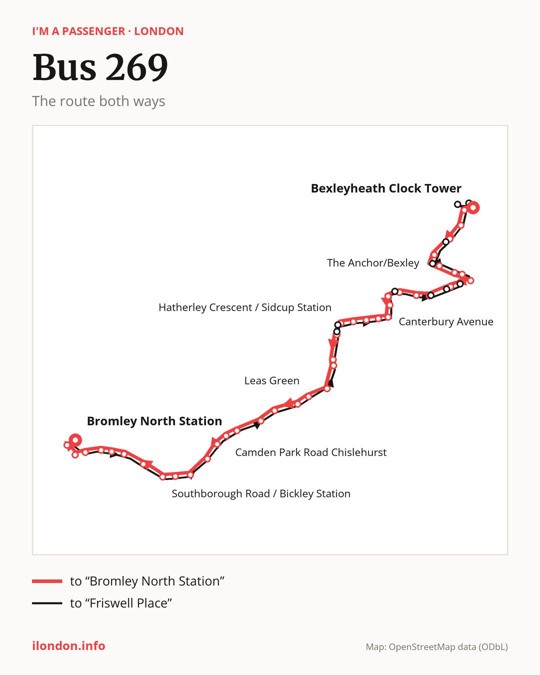
From “Bexleyheath Clock Tower” to “Bromley North Station”: 44 stops. On the way: “Bexleyheath Library”, “Latham Road”, “Townley Grammar School”, “Arbuthnot Lane”, “The Anchor/Bexley”, “Riverdale Road”, “Cross Lane”, “Parkhurst Road”, “Bexley War Memorial”, “Woodstock Close”. Then “Valentine Avenue”, “Carisbrooke Avenue”, “Crofton Avenue”, “Foots Cray Lane / Hurst Road”, “Canterbury Avenue”, “Wren Road”, “Melville Road (DA14)”, “Birchwood Avenue (DA14)”, “Hemmings Close”, “Hatherley Crescent / Sidcup Station”. Then “Station Road / Crescent Road”, “Sidcup / Carlton Road”, “The Green Sidcup”, “Queen Mary’s Hospital Sidcup”, “Leas Green”, “Beaverwood Road”, “Ashfield Lane”, “Bromley Lane / Chislehurst War Memorial”, “Chislehurst Common”, “Camden Park Road Chislehurst”. Then “Susan Wood”, “Chislehurst Station”, “Blackbrook Lane”, “Bickley Park Road / St Georges Church”, “Southborough Road / Bickley Station”, “Bird In Hand Lane”, “Plaistow Lane”, “Wanstead Road”, “Freelands Road”, “Bromley / Widmore Road”. Before “Bromley North Station”: “Court Street”, “West Street Bromley”.
The return journey is different. Towards “Friswell Place”: 45 stops. Only in this direction does it call at, among others, “Crescent Road (DA15)”, “Sidcup Station / Station Road”, “Eynsford Crescent”, “Hurst Springs”, “Grange Wood” and “Parkwood Road Bexley”. Only in the direction of “Bromley North Station” does it call at, among others, “The Anchor/Bexley”, “Parkhurst Road”, “Woodstock Close”, “Valentine Avenue”, “Hatherley Crescent / Sidcup Station” and “Station Road / Crescent Road”. For the way back, board nearby: “The Anchor/Bexley” → “Bridgen / The Anchor” (50 m), “Parkhurst Road” → “Cross Lane” (200 m), “Woodstock Close” → “Grange Wood” (100 m) and “Valentine Avenue” → “Hurst Springs” (50 m). Towards “Bromley North Station”, board nearby: “Crescent Road (DA15)” → “Station Road / Crescent Road” (50 m), “Sidcup Station / Station Road” → “Hatherley Crescent / Sidcup Station” (100 m), “Eynsford Crescent” → “Crofton Avenue” (100 m) and “Hurst Springs” → “Valentine Avenue” (50 m).
Left column runs down, right column runs up. Filled stops are served both ways, dashed ones only one way: 9 towards “Bromley North Station” and 10 the other way. Tap a stop to see its name.
Other routes along the way
Shared sections with other routes: between “Chislehurst Common” and “Bromley / Widmore Road” it shares the road with route 162; between “Hatherley Crescent / Sidcup Station” and “Bromley Lane / Chislehurst War Memorial” it shares the road with route 160; between “Bexley War Memorial” and “Crofton Avenue” it shares the road with route 229.
Connections by stop, in route order:
- “Bexleyheath Clock Tower”: buses 89, 96, 99, 301, 401, 422, 486, 492, B11, B12, B13, B14, B15, B16 and SL3
- “Bexleyheath Library”: buses 89, 96, 99, 301, 401, 422, 486, 492, B11, B12, B13, B14, B15, B16 and SL3
- “Latham Road”: buses B13, B14 and SL3
- “Townley Grammar School”: bus B13
- “Bexley War Memorial”: buses 492 and B12
- Stops from “Crofton Avenue” to “Wren Road”: bus B14
- “Hemmings Close”: buses 51, 233, 286, 492 and SL3
- “Hatherley Crescent / Sidcup Station” (only towards “Bromley North Station”): buses 51, 233, 286, 492 and SL3
- “Station Road / Crescent Road” (only towards “Bromley North Station”): buses 51, 233, 286, 492 and SL3
- “Sidcup / Carlton Road”: buses 51, 233, 286, 321, 492, B14, R11 and SL3
- “The Green Sidcup”: buses 51, 233, 286, 321, 492, B14, R11 and SL3
- “Queen Mary’s Hospital Sidcup”: buses 286, B14, R11 and SL3
- “Bromley Lane / Chislehurst War Memorial”: buses 61, 161, 273 and SL3
- “Chislehurst Common”: buses 61, 161 and 273
- “Camden Park Road Chislehurst”: bus R7
- “Susan Wood”: buses R7 and SL3
- “Chislehurst Station”: buses R7 and SL3
- “Blackbrook Lane”: bus R7
- “Bickley Park Road / St Georges Church”: buses R7 and SL3
- “Southborough Road / Bickley Station”: buses 336, R7 and SL3
- “Freelands Road”: bus SL3
- “Bromley / Widmore Road”: buses 61, 119, 126, 138, 146, 208, 227, 261, 314, 320, 336, 352, 354, 358, 367, SL3 and SL5
- “Court Street” (only towards “Bromley North Station”): buses 61, 119, 126, 138, 146, 208, 227, 261, 314, 320, 336, 352, 354, 358, 367, SL3 and SL5
- “West Street Bromley” (only towards “Bromley North Station”): buses 61, 119, 126, 138, 146, 208, 227, 261, 314, 320, 336, 352, 354, 358, 367, SL3 and SL5
- “Bromley North Station”: buses 61, 119, 126, 138, 146, 208, 227, 261, 314, 320, 336, 352, 354, 358, 367, SL3 and SL5
- “Crescent Road (DA15)” (only towards “Friswell Place”): buses 51, 233, 286, 492 and SL3
- “Sidcup Station / Station Road” (only towards “Friswell Place”): buses 51, 233, 286, 492 and SL3
- “Eynsford Crescent” (only towards “Friswell Place”): bus B14
- “Upton Road Bexley” (only towards “Friswell Place”): bus B13
- “Trinity Place” (only towards “Friswell Place”): buses 89, 96, 401, 422, 486, B11, B12, B13, B14, B15, B16 and SL3
- “Friswell Place”: buses 89, 96, 99, 301, 401, 422, 486, 492, B11, B12, B13, B14, B15, B16 and SL3
Pages for these routes: bus B11, bus B12, bus B13, bus B14, bus B15, bus B16, bus R11, bus R7, bus SL3, bus SL5, bus 51, bus 61, bus 89, bus 96, bus 99, bus 119, bus 126, bus 138, bus 146, bus 160, bus 161, bus 162, bus 208, bus 227, bus 229, bus 233.
Passes and concessions
Our page “How to pay for public transport in London” describes tickets, passes and concessions, including any differences between modes of transport.
Questions and answers
Does bus 269 go to “Bexleyheath Library”?
Yes, in both directions.
Where can I change from bus 269 to another bus route?
Most routes stop at “Bromley / Widmore Road” (61, 119, 126, 138, 146, 208, 227, 261, 314, 320, 336, 352, 354, 358, 367, SL3 and SL5) and “Court Street” (only towards “Bromley North Station”; 61, 119, 126, 138, 146, 208, 227, 261, 314, 320, 336, 352, 354, 358, 367, SL3 and SL5). All other stops with connections are listed above.
Checked on 25 September 2026. Source of the route and stops: Transport for London (TfL).