
Bus route 89 in London runs between “Lewisham Station” and “Forest Rd / Slade Green Stn”.
Which way bus 89 runs
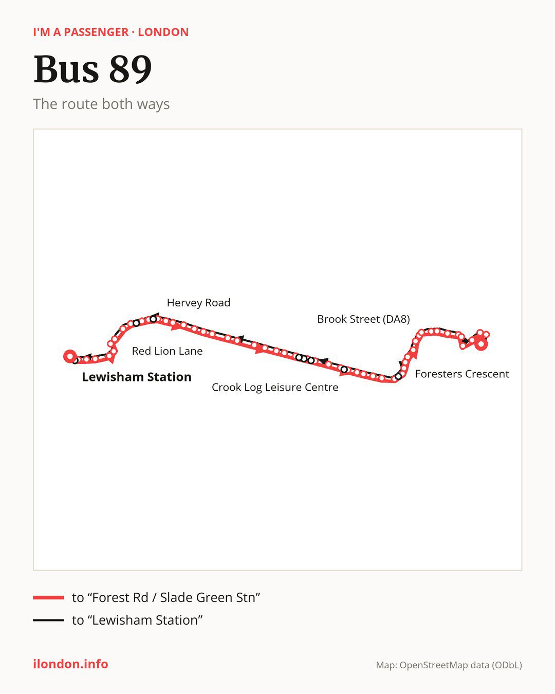
Towards “Forest Rd / Slade Green Stn”: 54 stops. After “Lewisham Station”, the bus calls at “Lockmead Road”, “The Squirrels”, “St Margaret’s Church / Brandram Road”, “Blackheath Hospital”, “Blackheath”, “Royal Parade (SE3)”, “Montpelier Row”, “St Germans Place”, “Shooters Hill Road / Stratheden Road”, “Shooters Hill Road / Kidbrooke Park Road”. Then “Shooters Hill Rd/Eastbrook Rd”, “Hervey Road”, “Weyman Road”, “Charlton Park Lane”, “Pallet Way”, “Shooters Hill Road/Baker Road”, “Shooters Hill Rd/Well Hall Rd”, “Red Lion Lane”, “Memorial Hospital”, “Eaglesfield Road Shooters Hill”. Then “Oxleas Wood / Woodlands Farm”, “Eastcote Road Falconwood”, “Bellegrove Road / Sherwood Rd”, “Bellegrove Road / Welling Way”, “Central Avenue / Welling Station”, “Deepdene Road”, “Welling High St/UpperWickhamLn”, “Guy Earl Of Warwick”, “Bethel Road”, “Crook Log Leisure Centre”. Then “Crook Log / Dallin Road”, “Upton Road Bexleyheath”, “Bexleyheath / Lion Road”, “Trinity Place”, “Bexleyheath Clock Tower”, “Foresters Crescent”, “Bexleyheath Bus Garage”, “Long Lane (DA3)”, “Lyndhurst Road”, “Barnehurst Station”. Then “Rydal Drive”, “Brook Street (DA8)”, “Barnehurst Avenue”, “Hurst Road”, “Northumberland Way”, “Colyers Walk”, “Myrtle Close”, “Northend Road / Colyers Lane”, “Bridge Road / Northend Road”, “Masefield Close”. Before “Forest Rd / Slade Green Stn”: “Bridge Road / Slade Green Road”, “Hazel Road”.
On the way back, from “Forest Rd / Slade Green Stn” to “Lewisham Station”: 54 stops. Only in this direction does it call at, among others, “Tower Road”, “Park View Road / Crook Log”, “Bellegrove Rd / Churchfield Rd”, “Ruskin Drive”, “Ruskin Avenue / Welling Station” and “Old Dover Road”. Only in the direction of “Forest Rd / Slade Green Stn” does it call at, among others, “Royal Parade (SE3)”, “Shooters Hill Road / Stratheden Road”, “Shooters Hill Rd/Eastbrook Rd”, “Central Avenue / Welling Station”, “Deepdene Road” and “Crook Log Leisure Centre”. For the way back, board nearby: “Royal Parade (SE3)” → “Montpelier Row” (200 m), “Shooters Hill Road / Stratheden Road” → “Kidbrooke Grove” (200 m), “Shooters Hill Rd/Eastbrook Rd” → “Old Dover Road” (150 m) and “Central Avenue / Welling Station” → “Ruskin Avenue / Welling Station” (100 m). Towards “Forest Rd / Slade Green Stn”, board nearby: “Tower Road” → “Bexleyheath Clock Tower” (150 m), “Park View Road / Crook Log” → “Crook Log Leisure Centre” (100 m), “Bellegrove Rd / Churchfield Rd” → “Welling High St/UpperWickhamLn” (150 m) and “Ruskin Drive” → “Deepdene Road” (100 m).
Left column runs down, right column runs up. Filled stops are served both ways, dashed ones only one way: 8 towards “Forest Rd / Slade Green Stn” and 8 the other way. Tap a stop to see its name.
Other routes along the way
On part of the route, between “Shooters Hill Road/Baker Road” and “Trinity Place” it shares the road with route 486; between “Central Avenue / Welling Station” and “Bexleyheath Bus Garage” it shares the road with route B16; between “Welling High St/UpperWickhamLn” and “Bexleyheath Clock Tower” it shares the road with route 96.
Connections by stop, in route order:
- “Lewisham Station”: buses 21, 47, 75, 122, 129, 136, 178, 181, 185, 199, 208, 225, 261, 273, 284, 321, 380, 436, 484, BL1 and P4
- “Lockmead Road”: buses 21, 47, 75, 122, 129, 136, 178, 181, 185, 199, 208, 225, 261, 273, 284, 321, 380, 436, 484, BL1 and P4
- “The Squirrels”: buses 122, 178, 261, 273 and 321
- “Blackheath Hospital”: buses 202, 380 and SL4
- “Blackheath”: buses 202, 380, 386 and SL4
- “Royal Parade (SE3)” (only towards “Forest Rd / Slade Green Stn”): buses 202, 380, 386 and SL4
- “Montpelier Row”: buses 202, 380, 386 and SL4
- “St Germans Place”: buses 53, 202, 286, 335, 380 and SL4
- “Shooters Hill Road / Stratheden Road” (only towards “Forest Rd / Slade Green Stn”): buses 53, 178, 202, 286, 335, 380 and SL4
- “Shooters Hill Road / Kidbrooke Park Road”: buses 132, 178, 286, 335, 386 and SL4
- “Shooters Hill Rd/Eastbrook Rd” (only towards “Forest Rd / Slade Green Stn”): buses 132, 178, 286, 335, 386 and SL4
- Stops from “Hervey Road” to “Charlton Park Lane”: buses 178 and 386
- “Pallet Way”: buses 161, 178, 244 and 386
- “Shooters Hill Road/Baker Road”: buses 161, 178, 244 and 386
- “Shooters Hill Rd/Well Hall Rd”: buses 122, 161 and 244
- “Red Lion Lane”: buses 122, 161 and 244
- “Memorial Hospital”: bus 244
- “Eaglesfield Road Shooters Hill”: bus 244
- “Bellegrove Road / Sherwood Rd”: bus B15
- “Bellegrove Road / Welling Way”: bus B15
- “Central Avenue / Welling Station” (only towards “Forest Rd / Slade Green Stn”): buses 51 and B15
- “Deepdene Road” (only towards “Forest Rd / Slade Green Stn”): buses 51 and B15
- “Welling High St/UpperWickhamLn”: buses 51 and B15
- “Bethel Road”: bus B14
- “Crook Log Leisure Centre” (only towards “Forest Rd / Slade Green Stn”): bus B14
- “Crook Log / Dallin Road”: buses 422, B11, B12, B14 and B15
- “Upton Road Bexleyheath”: buses 422, B11, B12, B14, B15 and SL3
- “Bexleyheath / Lion Road”: buses 269, 422, B11, B12, B14, B15 and SL3
- “Trinity Place”: buses 269, 401, 422, B11, B12, B13, B14, B15 and SL3
- “Bexleyheath Clock Tower”: buses 99, 132, 269, 301, 401, 422, 492, B11, B12, B13, B14, B15 and SL3
- “Foresters Crescent” (only towards “Forest Rd / Slade Green Stn”): buses 99, 132, 301, 492, B11 and B12
- “Bexleyheath Bus Garage”: buses 99, 492 and B11
- “Long Lane (DA3)”: buses 99, 301, 401, 492 and B11
- “Barnehurst Station”: bus 99
- “Myrtle Close”: bus 428
- Stops from “Northend Road / Colyers Lane” to “Masefield Close”: buses 99 and 428
- “Bridge Road / Slade Green Road”: bus 99
- “Hazel Road”: bus 99
- “Forest Rd / Slade Green Stn”: buses 99 and 428
- “Tower Road” (only towards “Lewisham Station”): buses 99, 132, 269, 301, 401, 422, 492, B11, B12 and B15
- “Park View Road / Crook Log” (only towards “Lewisham Station”): bus B14
- Stops from “Bellegrove Rd / Churchfield Rd” to “Ruskin Avenue / Welling Station” (only towards “Lewisham Station”): buses 51 and B15
- “Old Dover Road” (only towards “Lewisham Station”): buses 178 and 386
- “Kidbrooke Grove” (only towards “Lewisham Station”): buses 132, 178, 286, 335, 386 and SL4
- “Lewisham Clock Tower” (only towards “Lewisham Station”): buses 21, 47, 75, 122, 129, 136, 178, 181, 185, 199, 208, 225, 261, 273, 284, 321, 380, 436, 484, BL1 and P4
Pages for these routes: bus B11, bus B12, bus B13, bus B14, bus B15, bus B16, bus BL1, bus P4, bus SL3, bus SL4, bus 21, bus 47, bus 51, bus 53, bus 75.
Passes and concessions
Which passes are available and who travels free is explained on a separate page: how to pay for public transport in London.
Questions and answers
Does bus 89 go to “Blackheath Hospital”?
Yes, in both directions.
Where can I change from bus 89 to another bus route?
Most routes stop at “Lewisham Station” and “Lockmead Road” (21, 47, 75, 122, 129, 136, 178, 181, 185, 199, 208, 225, 261, 273, 284, 321, 380, 436, 484, BL1 and P4). All other stops with connections are listed above.
Checked on 5 October 2026. Source of the route and stops: Transport for London (TfL).