
Bus route 359 in London goes from “Purley / Downlands Precinct” to “Addington Village Interchange”. The return journey ends at “Purley High Street” (100 m from “Purley / Downlands Precinct”).
The route of bus 359
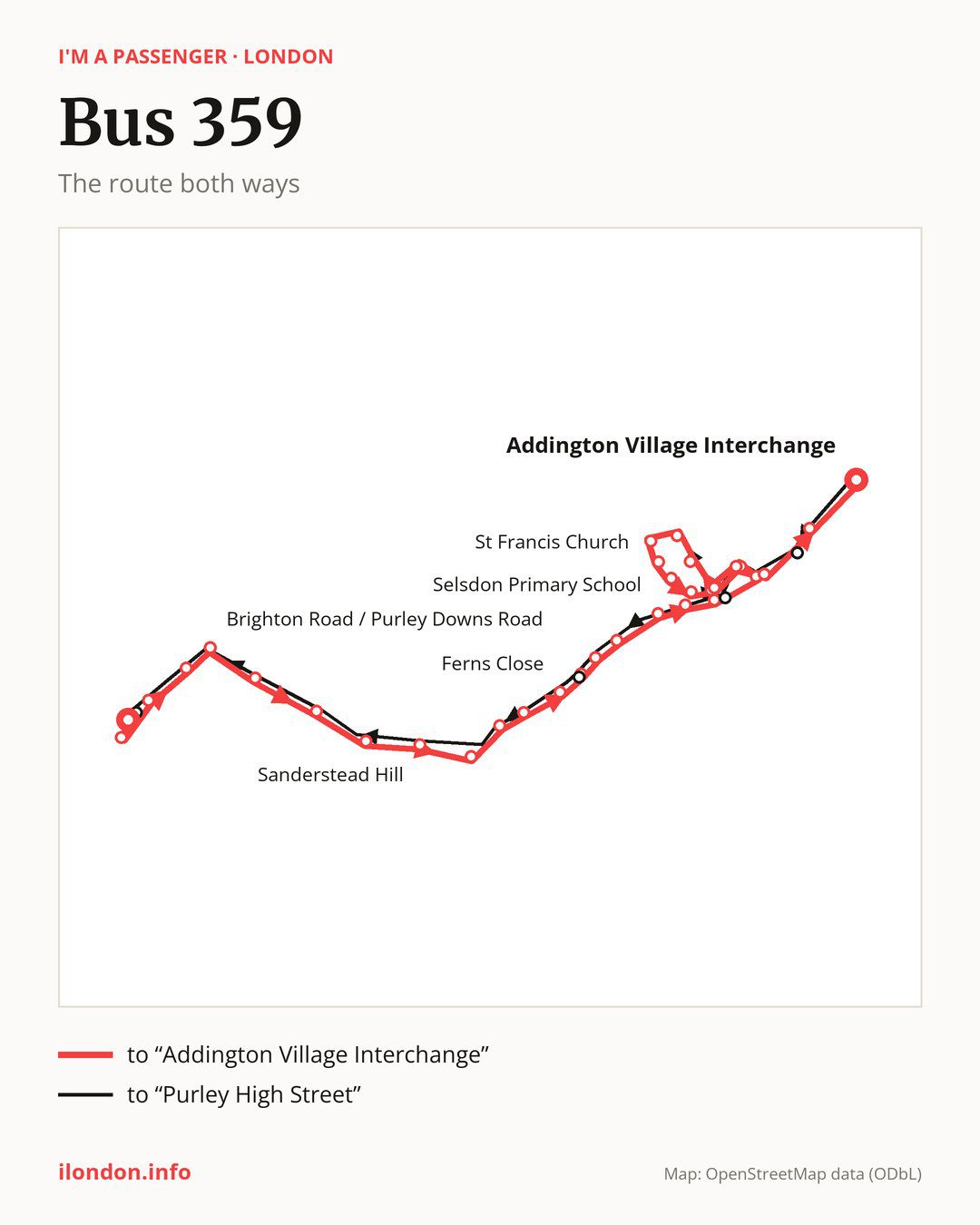
From “Purley / Downlands Precinct” to “Addington Village Interchange”: 33 stops. On the way: “Purley Station / Purley High Street”, “Christchurch Road / Purley Hospital”, “Montpelier Road”, “Brighton Road / Purley Downs Road”, “Norman Avenue”, “Maywater Close”, “Downsway”, “Sanderstead Hill”, “Sanderstead / All Saints Church”, “Harbledown Road”. Then “Sanderstead Plantation”, “Ferns Close”, “Farley Road”, “Old Farleigh Road”, “Selsdon Crescent”, “Selsdon Primary School”, “Ashen Vale”, “Pixton Way Selsdon”, “Farnborough Crescent”, “Lomond Gardens”. Then “Heathfield Vale / Tedder Road”, “Freelands Avenue”, “Shepherds Way”, “St Francis Church”, “Tedder Road”, “Edgecoombe”, “Heather Way”, “Heathfield Vale / Broadcoombe”, “Heathfield Vale / Farnborough Av”, “John Ruskin College”. Before “Addington Village Interchange”: “Gravel Hill (CR2)”.
The return journey is different. Towards “Purley High Street”: 31 stops. Only in this direction does it call at “Featherbed Lane”, “Monks Hill” and “Selsdon Library”. Only in the direction of “Addington Village Interchange” does it call at “Purley Station / Purley High Street”, “Christchurch Road / Purley Hospital”, “Farley Road”, “Ashen Vale” and “John Ruskin College”. For the way back, board nearby: “Purley Station / Purley High Street” → “Purley High Street” (250 m), “Christchurch Road / Purley Hospital” → “Purley High Street” (150 m), “Farley Road” → “Selsdon Library” (50 m) and “Ashen Vale” → “Heather Way” (100 m). Towards “Addington Village Interchange”, board nearby: “Featherbed Lane” → “Gravel Hill (CR2)” (200 m), “Monks Hill” → “Pixton Way Selsdon” (100 m) and “Selsdon Library” → “Farley Road” (50 m).
Left column runs down, right column runs up. Filled stops are served both ways, dashed ones only one way: 6 towards “Addington Village Interchange” and 4 the other way. Tap a stop to see its name.
Other routes along the way
Shared sections with other routes: between “Old Farleigh Road” and “Pixton Way Selsdon” it shares the road with route 64; between “Sanderstead / All Saints Church” and “Farley Road” it shares the road with route 412.
Connections by stop, in route order:
- “Purley / Downlands Precinct”: buses 60, 127, 166, 289, 312, 405, 407, 434, 439 and 466
- “Purley Station / Purley High Street” (only towards “Addington Village Interchange”): buses 60, 127, 166, 289, 312, 405, 407, 434, 439 and 466
- “Christchurch Road / Purley Hospital” (only towards “Addington Village Interchange”): buses 60, 127, 166, 289, 312, 405, 407, 434, 439 and 466
- “Montpelier Road”: buses 60, 166, 312, 405, 407 and 466
- “Brighton Road / Purley Downs Road”: buses 60, 166, 312, 405, 407 and 466
- “Sanderstead Hill”: bus 403
- “Sanderstead / All Saints Church”: bus 403
- “Ferns Close”: buses 409 and 433
- “Farley Road” (only towards “Addington Village Interchange”): buses 409 and 433
- “Old Farleigh Road”: buses 409 and 433
- “Selsdon Crescent”: buses 409 and 433
- “Farnborough Crescent”: bus 433
- “Gravel Hill (CR2)”: buses 130, 353, 433 and 466
- “Addington Village Interchange”: buses 130, 314, 353, 433 and 466
- “Featherbed Lane” (only towards “Purley High Street”): buses 130, 353, 433 and 466
- “Monks Hill” (only towards “Purley High Street”): bus 433
- “Selsdon Library” (only towards “Purley High Street”): buses 409 and 433
- “Purley High Street”: buses 60, 127, 166, 289, 312, 405, 407, 434, 439 and 466
Pages for these routes: bus 60, bus 64, bus 127, bus 130, bus 166, bus 289, bus 312, bus 314.
Passes and concessions
Our page “How to pay for public transport in London” describes tickets, passes and concessions, including any differences between modes of transport.
Questions and answers
Where can I change from bus 359 to another bus route?
Most routes stop at “Purley / Downlands Precinct” (60, 127, 166, 289, 312, 405, 407, 434, 439 and 466) and “Purley Station / Purley High Street” (only towards “Addington Village Interchange”; 60, 127, 166, 289, 312, 405, 407, 434, 439 and 466). All other stops with connections are listed above.
How many stops does bus 359 have?
33 towards “Addington Village Interchange” and 31 towards “Purley High Street”, counting the stops at each end.
Checked on 5 October 2026. Source of the route and stops: Transport for London (TfL).