
Bus route 166 in London runs between “Marks and Spencer” and “West Croydon Bus Station”.
Where bus 166 goes
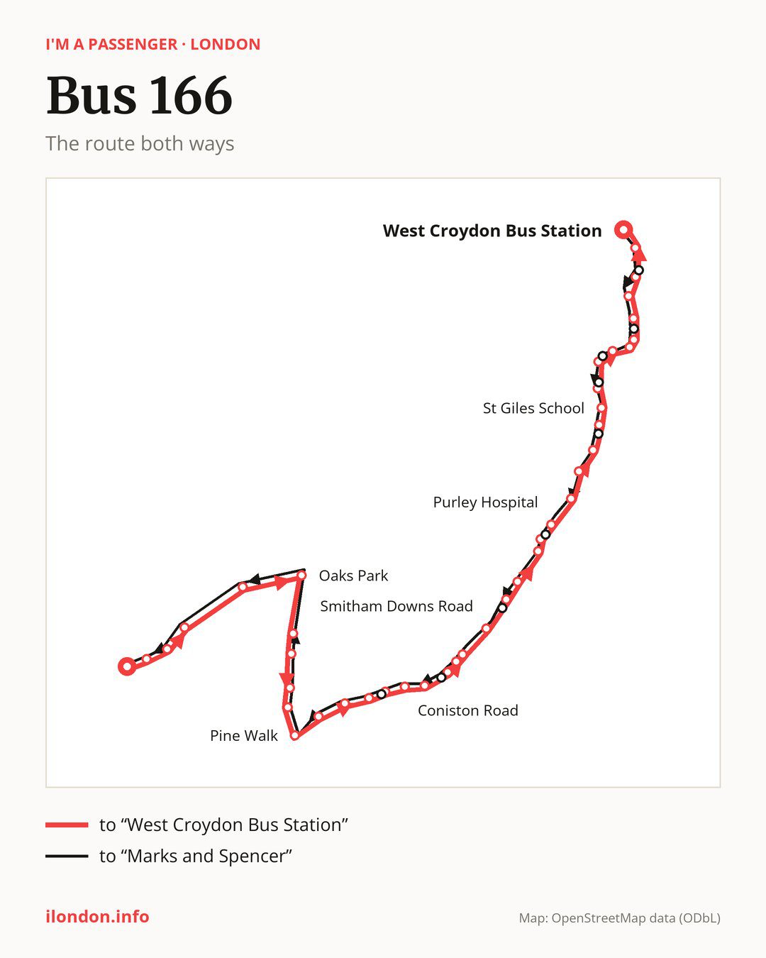
Towards “West Croydon Bus Station”: 41 stops. After “Marks and Spencer”, the bus calls at “Glenfield Road”, “The Woolpack”, “Croydon Lane South”, “Fairlawn Grove”, “Oaks Park”, “Merrymeet”, “Post Office”, “The Readens”, “Manor Way”, “Pine Walk”. Then “Rectory Lane”, “Chipstead Valley School”, “Woodmansterne Station”, “Chipstead Valley Rd / Rickman Hill”, “Coniston Road”, “Portnalls Road”, “Coulsdon Town”, “The Avenue Coulsdon”, “Willow Court”, “Smitham Downs Road”. Then “Brighton Road / Old Lodge Lane”, “Grovelands Road (CR8)”, “Purley Tesco”, “Purley Library”, “Purley Hospital”, “Wyvern Road”, “Lynscott Way”, “Blackford Close”, “Regina Coeli School”, “St Giles School”. Before “West Croydon Bus Station”: “Haling Park Gardens”, “Whitgift Avenue”, “Croydon Bowling Club”, “Warham Road / Brighton Road”, “Swan & Sugar Loaf”, “Coombe Road”, “Croydon Flyover”, “St George’s Walk / Croydon Town Centre”, “Whitgift Centre”.
On the way back, from “West Croydon Bus Station” to “Marks and Spencer”: 43 stops. Only in this direction does it call at, among others, “Park Street”, “Aberdeen Road South Croydon”, “Bramley Hill”, “Heath Close”, “Netherheys Drive” and “Purley Cross”. Only in the direction of “West Croydon Bus Station” does it call at, among others, “Chipstead Valley Rd / Rickman Hill”, “The Avenue Coulsdon”, “Purley Library”, “Haling Park Gardens”, “Whitgift Avenue” and “Swan & Sugar Loaf”. For the way back, board nearby: “Chipstead Valley Rd / Rickman Hill” → “Rickman Hill/Chipstead Valley” (50 m), “The Avenue Coulsdon” → “Willow Court” (150 m), “Purley Library” → “Purley Cross” (100 m) and “Haling Park Gardens” → “Heath Close” (100 m). Towards “West Croydon Bus Station”, board nearby: “Park Street” → “St George’s Walk / Croydon Town Centre” (100 m), “Aberdeen Road South Croydon” → “Coombe Road” (150 m), “Bramley Hill” → “Whitgift Avenue” (100 m) and “Heath Close” → “Haling Park Gardens” (100 m).
Left column runs down, right column runs up. Filled stops are served both ways, dashed ones only one way: 7 towards “West Croydon Bus Station” and 9 the other way. Tap a stop to see its name.
Where to change
On part of the route, between “Coulsdon Town” and “Croydon Flyover” it shares the road with route 405; between “Coulsdon Town” and “Purley Tesco” it shares the road with route 60; between “Croydon Bowling Club” and “St George’s Walk / Croydon Town Centre” it shares the road with route 119.
Connections by stop, in route order:
- Stops from “Marks and Spencer” to “Croydon Lane South”: buses 420 and S1
- “Chipstead Valley School”: bus 463
- “Woodmansterne Station”: bus 463
- “Chipstead Valley Rd / Rickman Hill” (only towards “West Croydon Bus Station”): bus 463
- “Coniston Road”: bus 463
- “Portnalls Road”: buses 404 and 463
- “Coulsdon Town”: buses 404 and 463
- “The Avenue Coulsdon” (only towards “West Croydon Bus Station”): buses 404 and 463
- “Willow Court”: buses 404 and 463
- “Brighton Road / Old Lodge Lane”: bus 312
- “Grovelands Road (CR8)”: bus 312
- “Purley Tesco”: buses 127, 289, 312, 359, 412 and 439
- “Purley Library” (only towards “West Croydon Bus Station”): buses 127, 289, 312, 359, 412 and 439
- “Purley Hospital”: buses 127, 289, 312, 359, 412 and 439
- “Wyvern Road”: buses 289, 312, 359 and 439
- “Croydon Bowling Club”: buses 312, 403, 412 and 468
- “Warham Road / Brighton Road”: buses 312, 403, 412 and 468
- “Swan & Sugar Loaf” (only towards “West Croydon Bus Station”): buses 312, 403, 412 and 468
- “Coombe Road”: buses 312, 403, 412 and 468
- “Croydon Flyover”: tram Tram; buses 50, 75, 109, 154, 197, 312, 403, 412, 433, 468 and SL5
- “St George’s Walk / Croydon Town Centre” (only towards “West Croydon Bus Station”): tram Tram; buses 50, 64, 75, 109, 154, 194, 197, 198, 312, 367, 403, 412, 433, 468 and SL5
- “Whitgift Centre”: tram Tram; buses 50, 64, 75, 109, 154, 157, 194, 198, 250, 264, 289, 312, 367, 403, 410, 412, 433, 450, 468, SL5, SL6 and SL7
- “West Croydon Bus Station”: tram Tram; buses 50, 64, 75, 109, 154, 157, 194, 198, 250, 264, 289, 367, 403, 410, 450, 468, SL6 and SL7
- “Park Street” (only towards “Marks and Spencer”): tram Tram; buses 50, 64, 75, 109, 154, 194, 197, 198, 312, 367, 403, 410, 412, 433, 468, SL5 and SL7
- “Aberdeen Road South Croydon” (only towards “Marks and Spencer”): buses 312, 403, 412 and 468
- “Purley Cross” (only towards “Marks and Spencer”): buses 127, 289, 312, 359, 412 and 439
- “Musgrove Close” (only towards “Marks and Spencer”): bus 312
- “Chipstead Valley Rd / Brighton Rd” (only towards “Marks and Spencer”): buses 404 and 463
- “Rickman Hill/Chipstead Valley” (only towards “Marks and Spencer”): bus 463
Pages for these routes: tram Tram, bus S1, bus SL5, bus SL6, bus SL7, bus 50, bus 60, bus 64, bus 75, bus 109, bus 119, bus 127.
Passes and concessions
Which passes are available and who travels free is explained on a separate page: how to pay for public transport in London.
Questions about bus 166
Does bus 166 go to “Oaks Park”?
Yes, in both directions.
Where can I change from bus 166 to another bus route?
Most routes stop at “Whitgift Centre” (50, 64, 75, 109, 154, 157, 194, 198, 250, 264, 289, 312, 367, 403, 410, 412, 433, 450, 468, SL5, SL6 and SL7) and “West Croydon Bus Station” (50, 64, 75, 109, 154, 157, 194, 198, 250, 264, 289, 367, 403, 410, 450, 468, SL6 and SL7). All other stops with connections are listed above.
Checked on 7 October 2026. Source of the route and stops: Transport for London (TfL).