
Bus route 198 in London links “Shrublands / Bramble Close” and “Talbot Road Thornton Heath”. The return journey starts at “Nursery Road” (100 m from “Talbot Road Thornton Heath”).
Where bus 198 goes
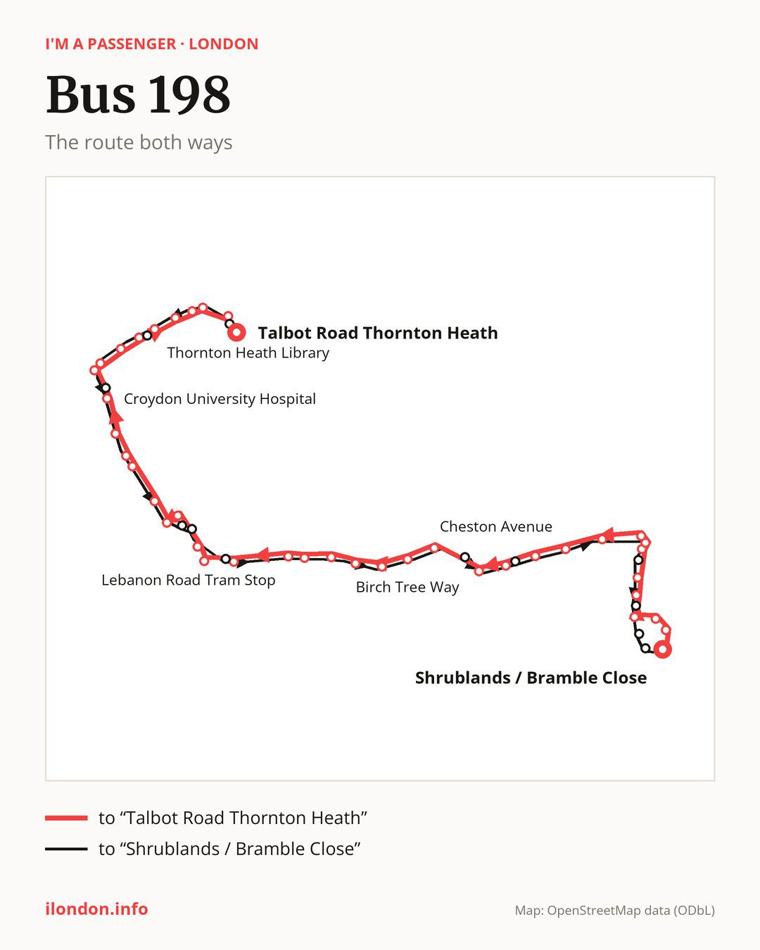
From “Shrublands / Bramble Close” to “Talbot Road Thornton Heath”: 41 stops. On the way: “Gorse Road”, “Broom Road”, “Bridle Road / Shirley”, “Links View Road”, “Worcester Close”, “Devonshire Way”, “Monks Orchard Road”, “Wickham Road / Monks Orchard”, “Langland Gardens (CR0)”, “Cheston Avenue”. Then “Shirley Library Wickham Road”, “Shirley Oaks Road”, “Upper Shirley Road”, “Trinity School Shirley”, “Birch Tree Way”, “Mapledale Avenue”, “Ashburton Road Addiscombe”, “Sandilands Tram Stop”, “Canning Road Addiscombe”, “Lebanon Road Tram Stop”. Then “East Croydon Rail Station”, “Electric House”, “Whitgift Centre”, “West Croydon Bus Station”, “West Croydon Station”, “Montague Road”, “Sumner Road Croydon”, “Broad Green Avenue”, “Canterbury Road (CR0)”, “Croydon University Hospital”. Before “Talbot Road Thornton Heath”: “Thornton Heath Pond”, “Brigstock Road / London Road”, “Whitehorse Manor Brigstock Site”, “Nutfield Road”, “Thornton Heath Library”, “Brook Road (CR7)”, “Thornton Heath Station”, “Thornton Heath Clock Tower”, “High Street / Whitehorse Lane”.
On the way back the bus takes a different route, from “Nursery Road” to “Shrublands / Bramble Close” (38 stops). Only in this direction does it call at “Bensham Lane”, “Dunheved Road North”, “Poplar Walk”, “Lunar House”, “Dingwall Road / East Croydon Station”, “Valley Walk”, “Verdayne Avenue”, “Ash Road (CR0)”, “Forest Academy”, “Laurel Crescent” and “Fir Tree Gardens”. Only in the direction of “Talbot Road Thornton Heath” does it call at, among others, “Gorse Road”, “Broom Road”, “Bridle Road / Shirley”, “Worcester Close”, “Devonshire Way” and “Wickham Road / Monks Orchard”. For the way back, board nearby: “Gorse Road” → “Shrublands / Bramble Close” (200 m), “Broom Road” → “Laurel Crescent” (250 m), “Bridle Road / Shirley” → “Forest Academy” (100 m) and “Worcester Close” → “Links View Road” (200 m). Towards “Talbot Road Thornton Heath”, board nearby: “Bensham Lane” → “Nutfield Road” (100 m), “Dunheved Road North” → “Croydon University Hospital” (100 m), “Poplar Walk” → “West Croydon Bus Station” (100 m) and “Lunar House” → “Whitgift Centre” (200 m).
Left column runs down, right column runs up. Filled stops are served both ways, dashed ones only one way: 15 towards “Talbot Road Thornton Heath” and 12 the other way. Tap a stop to see its name.
Where to change
Shared sections with other routes: between “Wickham Road / Monks Orchard” and “East Croydon Rail Station” it shares the road with route 119; between “Shirley Library Wickham Road” and “West Croydon Bus Station” it shares the road with route 194; between “West Croydon Bus Station” and “Thornton Heath Station” it shares the road with route 250.
Connections by stop, in route order:
- “Devonshire Way” (only towards “Talbot Road Thornton Heath”): buses 356 and SL5
- “Monks Orchard Road”: buses 356 and SL5
- “Wickham Road / Monks Orchard” (only towards “Talbot Road Thornton Heath”): buses 356 and SL5
- “Cheston Avenue”: buses 367 and SL5
- “Shirley Library Wickham Road”: buses 367 and SL5
- “Shirley Oaks Road” (only towards “Talbot Road Thornton Heath”): buses 367 and SL5
- “Upper Shirley Road”: buses 130, 367 and 466
- “Trinity School Shirley”: buses 130, 367 and 466
- “Birch Tree Way”: bus 466
- “Mapledale Avenue”: bus 466
- “Ashburton Road Addiscombe”: tram Tram; bus 466
- “Sandilands Tram Stop”: tram Tram; bus 466
- “Canning Road Addiscombe” (only towards “Talbot Road Thornton Heath”): tram Tram; bus 466
- “Lebanon Road Tram Stop”: tram Tram; buses 433 and 466
- “East Croydon Rail Station”: tram Tram; buses 50, 75, 154, 197, 312, 367, 403, 405, 410, 412, 433, 466, 468, SL5 and SL7
- “Electric House” (only towards “Talbot Road Thornton Heath”): tram Tram; buses 50, 75, 154, 166, 197, 312, 367, 403, 405, 407, 410, 412, 433, 466, 468, SL5 and SL7
- “Whitgift Centre”: tram Tram; buses 50, 75, 154, 157, 166, 197, 264, 289, 312, 367, 403, 405, 407, 410, 412, 433, 450, 466, 468, SL5, SL6 and SL7
- “West Croydon Bus Station” (only towards “Talbot Road Thornton Heath”): tram Tram; buses 50, 75, 154, 157, 166, 264, 289, 367, 403, 407, 410, 450, 468, SL6 and SL7
- “West Croydon Station”: tram Tram; buses 50, 75, 154, 157, 166, 264, 289, 367, 403, 407, 410, 450, 468, SL6 and SL7
- “Montague Road”: tram Tram; buses 75, 154, 157, 166, 264, 289, 367, 403, 407, 410, 450, SL6 and SL7
- “Sumner Road Croydon”: bus 289
- “Broad Green Avenue”: bus 289
- “Canterbury Road (CR0)” (only towards “Talbot Road Thornton Heath”): bus 289
- Stops from “Croydon University Hospital” to “Brigstock Road / London Road”: bus 289
- “Whitehorse Manor Brigstock Site”: bus 450
- “Nutfield Road” (only towards “Talbot Road Thornton Heath”): bus 450
- “Thornton Heath Library” (only towards “Talbot Road Thornton Heath”): bus 450
- Stops from “Brook Road (CR7)” to “Thornton Heath Clock Tower”: buses 50, 130 and 450
- “High Street / Whitehorse Lane” (only towards “Talbot Road Thornton Heath”): buses 50, 130, 468 and SL6
- “Talbot Road Thornton Heath”: buses 50, 130, 468 and SL6
- “Nursery Road”: buses 50, 130, 468 and SL6
- “Bensham Lane” (only towards “Shrublands / Bramble Close”): bus 450
- “Dunheved Road North” (only towards “Shrublands / Bramble Close”): bus 289
- “Poplar Walk” (only towards “Shrublands / Bramble Close”): tram Tram; buses 50, 75, 154, 157, 166, 264, 289, 367, 403, 407, 410, 450, 468, SL6 and SL7
- “Lunar House” (only towards “Shrublands / Bramble Close”): tram Tram; buses 50, 75, 154, 157, 166, 264, 289, 367, 403, 407, 410, 450, 468, SL6 and SL7
- “Dingwall Road / East Croydon Station” (only towards “Shrublands / Bramble Close”): tram Tram; buses 50, 75, 154, 166, 197, 312, 367, 403, 405, 407, 410, 412, 433, 466, 468, SL5 and SL7
- “Valley Walk” (only towards “Shrublands / Bramble Close”): buses 130, 367 and 466
- “Verdayne Avenue” (only towards “Shrublands / Bramble Close”): buses 367 and SL5
- “Ash Road (CR0)” (only towards “Shrublands / Bramble Close”): buses 356 and SL5
Pages for these routes: tram Tram, bus SL5, bus SL6, bus SL7, bus 50, bus 75, bus 119, bus 130, bus 154, bus 157, bus 166.
Passes and concessions
Which passes are available and who travels free is explained on a separate page: how to pay for public transport in London.
Questions about bus 198
Where does bus 198 start its return journey?
At “Nursery Road” (100 m from “Talbot Road Thornton Heath”).
Where can I change from bus 198 to another bus route?
Most routes stop at “Electric House” (only towards “Talbot Road Thornton Heath”; 50, 75, 154, 166, 197, 312, 367, 403, 405, 407, 410, 412, 433, 466, 468, SL5 and SL7) and “Whitgift Centre” (50, 75, 154, 157, 166, 197, 264, 289, 312, 367, 403, 405, 407, 410, 412, 433, 450, 466, 468, SL5, SL6 and SL7). All other stops with connections are listed above.
Checked on 29 September 2026. Source of the route and stops: Transport for London (TfL).