
Bus route 64 in London links “Thornton Heath Pond” and “Vulcan Way”.
Where bus 64 goes
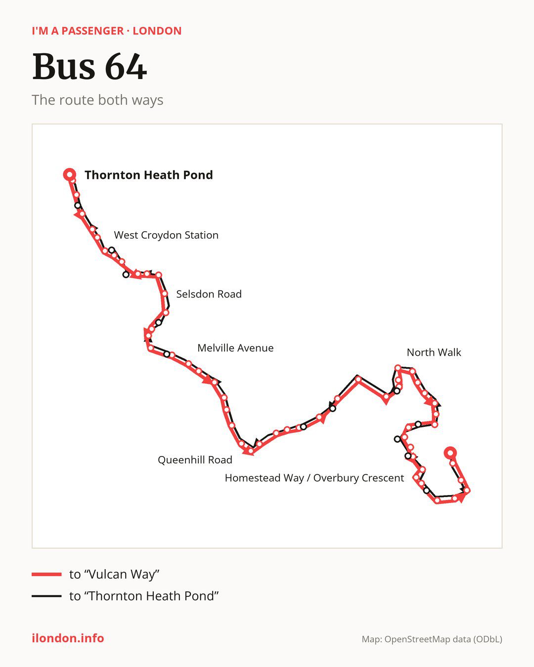
From “Thornton Heath Pond” to “Vulcan Way”: 56 stops. On the way: “Dunheved Road North”, “Croydon University Hospital”, “Broad Green Avenue”, “Sumner Road Croydon”, “Montague Road”, “West Croydon Station”, “Poplar Walk”, “Whitgift Centre”, “Dingwall Road / East Croydon Station”, “East Croydon Rail Station”. Then “Garrick Crescent”, “Selsdon Road”, “Selborne Road”, “Birdhurst Gardens”, “Elmhurst School”, “Birdhurst Road / South Croydon Station”, “St Pauls United Reformed Church”, “Melville Avenue”, “Manor Way (CR2)”, “Ballards Way”. Then “Farley Road / Croham Valley Rd”, “Littleheath Road”, “Brent Road (CR2)”, “Queenhill Road”, “Old Farleigh Road”, “Selsdon Crescent”, “Selsdon Primary School”, “Ashen Vale”, “Pixton Way Selsdon”, “John Ruskin College”. Then “Gravel Hill (CR2)”, “Addington Village Interchange”, “Applegarth”, “The Coppins”, “Foxcombe”, “North Walk”, “The Lindens”, “Castle Hill School”, “Merrow Way”, “Frimley Close”. Then “Goldcrest Community Centre”, “Goldcrest Way / King Henry’s Drive”, “Betchworth Way”, “Wolsey Crescent Montacute Road”, “Grenville Road”, “Salcot Crescent”, “Central Parade New Addington”, “Homestead Way / Overbury Crescent”, “Cleves Crescent”, “Kennelwood Crescent”. Before “Vulcan Way”: “Homestead Way / Milne Park”, “King Henry’s Drive / Homestead Way”, “Warbank Crescent”, “Redstart Close”.
The return journey is different. Towards “Thornton Heath Pond”: 58 stops. Only in this direction does it call at, among others, “Thorpe Close”, “New Addington Tram Stop”, “King Henry’s Drive Tram Stop”, “Tilford Avenue”, “Brierley” and “Featherbed Lane”. Only in the direction of “Vulcan Way” does it call at, among others, “Dunheved Road North”, “Poplar Walk”, “Dingwall Road / East Croydon Station”, “St Pauls United Reformed Church”, “Ashen Vale” and “The Coppins”. For the way back, board nearby: “Dunheved Road North” → “Thornton Heath Pond” (150 m), “Poplar Walk” → “West Croydon Bus Station” (100 m), “Dingwall Road / East Croydon Station” → “East Croydon Rail Station” (200 m) and “St Pauls United Reformed Church” → “Campden Road” (100 m). Towards “Vulcan Way”, board nearby: “Thorpe Close” → “Cleves Crescent” (150 m), “New Addington Tram Stop” → “Salcot Crescent” (100 m), “King Henry’s Drive Tram Stop” → “Wolsey Crescent Montacute Road” (150 m) and “Tilford Avenue” → “Betchworth Way” (200 m).
Left column runs down, right column runs up. Filled stops are served both ways, dashed ones only one way: 10 towards “Vulcan Way” and 12 the other way. Tap a stop to see its name.
Other routes along the way
Shared sections with other routes: between “East Croydon Rail Station” and “Queenhill Road” it shares the road with route 433; between “Thornton Heath Pond” and “Whitgift Centre” it shares the road with routes 60 and 109; between “Addington Village Interchange” and “Merrow Way” it shares the road with route 130.
Connections by stop, in route order:
- “Thornton Heath Pond”: bus 289
- “Dunheved Road North” (only towards “Vulcan Way”): bus 289
- Stops from “Croydon University Hospital” to “Sumner Road Croydon”: bus 289
- “Montague Road”: tram Tram; buses 75, 154, 157, 166, 194, 264, 289, 367, 403, 407, 410, 450, SL6 and SL7
- “West Croydon Station”: tram Tram; buses 50, 75, 154, 157, 166, 194, 264, 289, 367, 403, 407, 410, 450, 468, SL6 and SL7
- “Poplar Walk” (only towards “Vulcan Way”): tram Tram; buses 50, 75, 154, 157, 166, 194, 264, 289, 367, 403, 407, 410, 450, 468, SL6 and SL7
- “Whitgift Centre”: tram Tram; buses 50, 75, 119, 154, 157, 166, 194, 197, 264, 289, 312, 367, 403, 405, 407, 410, 412, 450, 466, 468, SL5, SL6 and SL7
- “Dingwall Road / East Croydon Station” (only towards “Vulcan Way”): tram Tram; buses 50, 75, 119, 154, 166, 194, 197, 312, 367, 403, 405, 407, 410, 412, 466, 468, SL5 and SL7
- “East Croydon Rail Station”: tram Tram; buses 50, 75, 119, 154, 194, 197, 312, 367, 403, 405, 410, 412, 466, 468, SL5 and SL7
- “Garrick Crescent”: tram Tram; buses 119, 194, 197, 312, 367, 410, 466, SL5 and SL7
- “Birdhurst Road / South Croydon Station”: buses 403 and 412
- “Brent Road (CR2)”: bus 412
- Stops from “Queenhill Road” to “Selsdon Crescent”: buses 359, 409 and 412
- “Selsdon Primary School”: bus 359
- “Ashen Vale” (only towards “Vulcan Way”): bus 359
- “Pixton Way Selsdon”: bus 359
- “John Ruskin College”: bus 359
- “Gravel Hill (CR2)”: buses 353, 359 and 466
- “Addington Village Interchange”: buses 314, 353, 359 and 466
- “Applegarth”: bus 314
- “The Coppins” (only towards “Vulcan Way”): bus 314
- Stops from “Castle Hill School” to “Goldcrest Way / King Henry’s Drive”: bus 314
- “Grenville Road” (only towards “Vulcan Way”): buses 314 and 464
- “Salcot Crescent” (only towards “Vulcan Way”): buses 314 and 464
- “Central Parade New Addington”: buses 314 and 464
- “Homestead Way / Overbury Crescent”: bus 464
- “Cleves Crescent” (only towards “Vulcan Way”): bus 464
- Stops from “Homestead Way / Milne Park” to “Redstart Close”: bus 464
- “New Addington Tram Stop” (only towards “Thornton Heath Pond”): buses 314 and 464
- “Tilford Avenue” (only towards “Thornton Heath Pond”): bus 314
- “Brierley” (only towards “Thornton Heath Pond”): bus 314
- “Featherbed Lane” (only towards “Thornton Heath Pond”): buses 353, 359 and 466
- “Monks Hill” (only towards “Thornton Heath Pond”): bus 359
- “Electric House” (only towards “Thornton Heath Pond”): tram Tram; buses 50, 75, 119, 154, 166, 194, 197, 312, 367, 403, 405, 407, 410, 412, 466, 468, SL5 and SL7
- “West Croydon Bus Station” (only towards “Thornton Heath Pond”): tram Tram; buses 50, 75, 154, 157, 166, 194, 264, 289, 367, 403, 407, 410, 450, 468, SL6 and SL7
- “Canterbury Road (CR0)” (only towards “Thornton Heath Pond”): bus 289
Pages for these routes: tram Tram, bus SL5, bus SL6, bus SL7, bus 50, bus 60.
Passes and concessions
Our page “How to pay for public transport in London” describes tickets, passes and concessions, including any differences between modes of transport.
Questions and answers
Does bus 64 go to “Croydon University Hospital”?
Yes, in both directions.
Where can I change from bus 64 to another bus route?
Most routes stop at “Whitgift Centre” (50, 75, 119, 154, 157, 166, 194, 197, 264, 289, 312, 367, 403, 405, 407, 410, 412, 450, 466, 468, SL5, SL6 and SL7) and “Dingwall Road / East Croydon Station” (only towards “Vulcan Way”; 50, 75, 119, 154, 166, 194, 197, 312, 367, 403, 405, 407, 410, 412, 466, 468, SL5 and SL7). All other stops with connections are listed above.
Checked on 27 September 2026. Source of the route and stops: Transport for London (TfL).