

Bus route S1 in London runs between “Marks and Spencer” and “Victoria Road / Lavender Fields”. In one direction or the other it serves 2 stops that it skips on the way back.
The route of bus S1
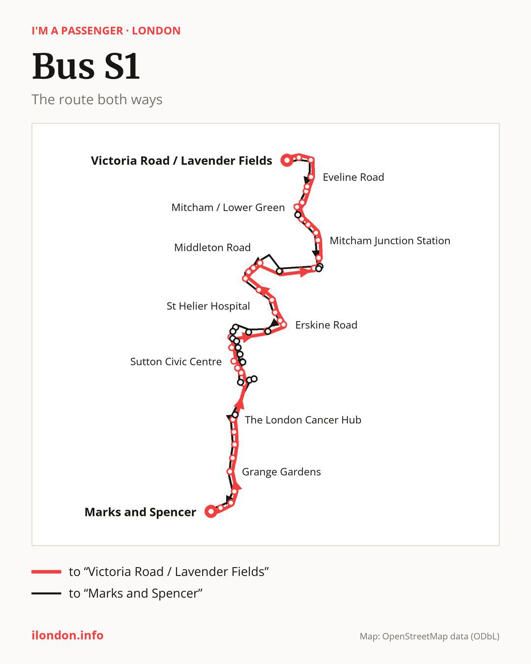
From “Marks and Spencer” to “Victoria Road / Lavender Fields”: 40 stops. On the way: “Glenfield Road”, “The Woolpack”, “Croydon Lane”, “Grange Gardens”, “Banstead Downs”, “Highdown Lane”, “Downs Road / Belmont Station”, “The London Cancer Hub”, “Langley Park Road”, “Sutton Station”. Then “Sutton / Grove Road”, “Sutton Civic Centre”, “St. Nicholas Centre”, “Crown Road (SM1)”, “Paget Avenue”, “Erskine Road”, “Poulton Avenue”, “Muschamp Road Carshalton”, “Welbeck Road St Helier”, “St Helier Hospital”. Then “Wrythe Lane / Rose Hill Roundabout”, “Bishopsford Road / Rose Hill Roundabout”, “Netley Road”, “Middleton Road”, “GREEN WRYTHE LANE”, “Mill Green Business Park”, “Goat Road”, “Mitcham Junction Station”, “Mitcham Garden Village / Willow Lane”, “The Wilson Hospital”. Before “Victoria Road / Lavender Fields”: “Mitcham Police Station”, “Mitcham / Lower Green”, “Glebe Court”, “Mitcham Fair Green”, “Downe Road / Mitcham Library”, “Eveline Road”, “London Road / Figge’s Marsh”, “Taylor Road”.
On the way back the bus takes a different route, from “Victoria Road / Lavender Fields” to “Marks and Spencer” (46 stops). Only in this direction does it call at “Mitcham / Cricket Green”, “Mill Green Road”, “Green Wrythe Lane / St. Helier Library”, “Orchard Way Erskine Road”, “Oakhill Road Sutton”, “Lewis Road (SM1)”, “Sutton Green”, “High Street / Marshalls Road”, “Benhill Avenue”, “Manor Place”, “Times Square”, “Sutton Police Station”, “Brighton Road / Cavendish Road”, “Cavendish Road (SM2)” and “Sutton Hospital”. Only in the direction of “Victoria Road / Lavender Fields” does it call at, among others, “Langley Park Road”, “Sutton / Grove Road”, “Sutton Civic Centre”, “St. Nicholas Centre”, “Crown Road (SM1)” and “Paget Avenue”. For the way back, board nearby: “Langley Park Road” → “Brighton Road / Cavendish Road” (100 m), “Sutton / Grove Road” → “Sutton Station” (150 m), “Sutton Civic Centre” → “Sutton Police Station” (250 m) and “St. Nicholas Centre” → “Manor Place” (200 m). Towards “Victoria Road / Lavender Fields”, board nearby: “Mitcham / Cricket Green” → “Mitcham Police Station” (150 m), “Mill Green Road” → “Mill Green Business Park” (200 m), “Orchard Way Erskine Road” → “Paget Avenue” (50 m) and “Lewis Road (SM1)” → “Crown Road (SM1)” (300 m).
Left column runs down, right column runs up. Filled stops are served both ways, dashed ones only one way: 9 towards “Victoria Road / Lavender Fields” and 15 the other way. Tap a stop to see its name.
Connections
Shared sections with other routes: between “Goat Road” and “Eveline Road” it shares the road with route 127; between “Marks and Spencer” and “The London Cancer Hub” it shares the road with route 420; between “Mitcham / Lower Green” and “London Road / Figge’s Marsh” it shares the road with route 280.
Connections by stop, in route order:
- Stops from “Marks and Spencer” to “Croydon Lane”: bus 166
- “Highdown Lane”: bus S4
- “Downs Road / Belmont Station”: bus S4
- “Langley Park Road” (only towards “Victoria Road / Lavender Fields”): buses 164, 470, S2 and S4
- “Sutton Station”: buses 151, 164, 213, 407, 413, 470, S2, S4 and SL7
- “Sutton / Grove Road” (only towards “Victoria Road / Lavender Fields”): buses 151, 164, 213, 407, 413, 470, S2, S4 and SL7
- “Sutton Civic Centre” (only towards “Victoria Road / Lavender Fields”): buses 151, 164, 213, 407, 413, 470, S2, S4 and SL7
- “St. Nicholas Centre” (only towards “Victoria Road / Lavender Fields”): buses 151, 154, 164, 213, 407, 413, 470, S2 and S4
- “Crown Road (SM1)” (only towards “Victoria Road / Lavender Fields”): buses 151, 154, 164, 213, 407, 413, 470, S2 and S4
- “Welbeck Road St Helier”: buses 151 and S2
- “St Helier Hospital”: buses 151 and S2
- “Wrythe Lane / Rose Hill Roundabout”: buses 151, 154, 164 and S2
- “Bishopsford Road / Rose Hill Roundabout”: buses 151, 154, 164 and S2
- “Netley Road”: bus 164
- “Mitcham Junction Station”: tram Tram
- “Mitcham Garden Village / Willow Lane”: tram Tram; bus 264
- “The Wilson Hospital”: bus 264
- “Mitcham Police Station”: buses 45 and 201
- “Mitcham / Lower Green” (only towards “Victoria Road / Lavender Fields”): buses 45, 200 and 201
- Stops from “Glebe Court” to “Downe Road / Mitcham Library”: buses 45, 152, 200, 201, 264, 270 and 355
- “Eveline Road”: buses 152, 201, 264, 270 and 355
- “London Road / Figge’s Marsh”: buses 264, 270 and 355
- “Mitcham / Cricket Green” (only towards “Marks and Spencer”): buses 45, 200 and 201
- “Green Wrythe Lane / St. Helier Library” (only towards “Marks and Spencer”): bus 151
- “Oakhill Road Sutton” (only towards “Marks and Spencer”): buses 154 and S2
- Stops from “Lewis Road (SM1)” to “Manor Place” (only towards “Marks and Spencer”): buses 151, 154, 164, 213, 407, 413, 470, S2 and S4
- “Times Square” (only towards “Marks and Spencer”): buses 151, 154, 164, 213, 407, 413, 470, S2, S4 and SL7
- “Sutton Police Station” (only towards “Marks and Spencer”): buses 151, 164, 213, 407, 413, 470, S2, S4 and SL7
- “Brighton Road / Cavendish Road” (only towards “Marks and Spencer”): buses 164, 470, S2 and S4
- “Cavendish Road (SM2)” (only towards “Marks and Spencer”): buses 164 and 470
Pages for these routes: tram Tram.
Passes and concessions
Tickets, passes and concessions are covered on a separate page: how to pay for public transport in London.
Questions and answers
Does bus S1 stop at “Green Wrythe Lane / St. Helier Library”?
Only in the direction of “Marks and Spencer”: in the other direction it does not stop there.
Does bus S1 go to “Downs Road / Belmont Station”?
Yes, in both directions.
Where can I change from bus S1 to another bus route?
Most routes stop at “Sutton Station” (151, 164, 213, 407, 413, 470, S2, S4 and SL7) and “Times Square” (only towards “Marks and Spencer”; 151, 154, 164, 213, 407, 413, 470, S2, S4 and SL7). All other stops with connections are listed above.
Checked on 30 September 2026. Source of the route and stops: Transport for London (TfL).