

Bus route S2 in London links “Clock Tower” and “St Helier Station”. The two directions are not quite the same: 2 stops are served in one direction only, which is worth knowing before you travel. The return journey ends at “High Street”.
Which way bus S2 runs
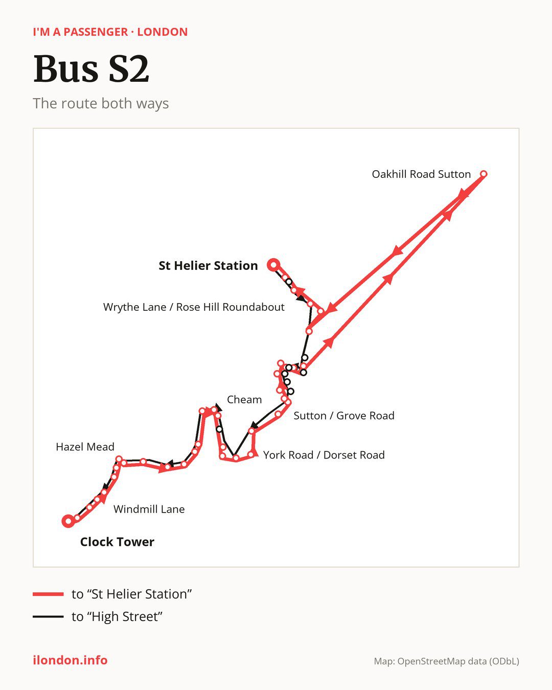
Towards “St Helier Station”: 38 stops. After “Clock Tower”, the bus calls at “High Street”, “Rainbow Leisure Centre”, “Kiln Lane”, “Windmill Lane”, “Hessle Grove”, “The Kingsway”, “Hazel Mead”, “Ewell East Railway Station”, “Springfield Road”, “Albury Avenue”. Then “Bramley Road”, “West Drive”, “Nonsuch Park”, “Cheam Broadway”, “Cheam”, “Sandy Lane Cheam”, “South Drive”, “Northey Avenue”, “York Road / Dorset Road”, “York Road (SM2)”. Then “Worcester Road”, “Sutton Station”, “Sutton / Grove Road”, “Sutton Civic Centre”, “St. Nicholas Centre”, “Sutton / Marshalls Road”, “Benhill Avenue / Throwley Way”, “Benhill Wood Road”, “Lind Road Sutton”, “Thicket Crescent”. Before “St Helier Station”: “Oakhill Road Sutton”, “Edinburgh Road”, “Whitby Road / St Helier”, “St Helier Hospital”, “Wrythe Lane / Rose Hill Roundabout”, “Canterbury Road (SM4)”.
On the way back the bus takes a different route, from “St Helier Station” to “High Street” (33 stops). Only in this direction does it call at “Dorchester Road”, “Thicket Road / Oakhill Road”, “Lower Road”, “Lenham Road (SM1)”, “Manor Place”, “Times Square”, “Sutton Police Station” and “Cheam Station”. Only in the direction of “St Helier Station” does it call at, among others, “Cheam”, “South Drive”, “York Road / Dorset Road”, “Sutton / Grove Road”, “Sutton Civic Centre” and “St. Nicholas Centre”. For the way back, board nearby: “Cheam” → “Cheam Broadway” (150 m), “South Drive” → “Sandy Lane Cheam” (200 m), “Sutton / Grove Road” → “Sutton Station” (100 m) and “Sutton Civic Centre” → “Sutton Police Station” (250 m). Towards “St Helier Station”, board nearby: “Dorchester Road” → “Canterbury Road (SM4)” (150 m), “Thicket Road / Oakhill Road” → “Thicket Crescent” (200 m), “Lower Road” → “Lind Road Sutton” (50 m) and “Lenham Road (SM1)” → “Benhill Avenue / Throwley Way” (50 m).
Left column runs down, right column runs up. Filled stops are served both ways, dashed ones only one way: 13 towards “St Helier Station” and 8 the other way. Tap a stop to see its name.
Other routes along the way
On part of the route, between “Clock Tower” and “High Street” it shares the road with routes 293, 406 and E16; between “Sutton Station” and “Sutton / Marshalls Road” it shares the road with route S4; between “Sutton Station” and “St. Nicholas Centre” it shares the road with routes 80 and S1.
Connections by stop, in route order:
- “Clock Tower”: buses 418 and 467
- “High Street”: bus 467
- “Rainbow Leisure Centre”: buses 418 and 467
- Stops from “Kiln Lane” to “Hazel Mead”: bus 467
- “Nonsuch Park”: buses 151, 213 and SL7
- “Cheam Broadway”: buses 151, 213 and SL7
- “Cheam” (only towards “St Helier Station”): buses 151, 213 and SL7
- “Worcester Road”: buses 280, 420 and S3
- “Sutton Station”: buses 151, 164, 213, 280, 407, 413, 420, 470, S3 and SL7
- “Sutton / Grove Road” (only towards “St Helier Station”): buses 151, 164, 213, 280, 407, 413, 420, 470, S3 and SL7
- “Sutton Civic Centre” (only towards “St Helier Station”): buses 151, 164, 213, 280, 407, 413, 420, 470, S3 and SL7
- Stops from “St. Nicholas Centre” to “Benhill Avenue / Throwley Way” (only towards “St Helier Station”): buses 151, 154, 164, 213, 280, 407, 413, 420, 470 and S3
- “Benhill Wood Road”: buses 151, 154, 164, 213, 280, 407, 413, 420, 470 and S3
- “Lind Road Sutton” (only towards “St Helier Station”): buses 154 and S3
- “Thicket Crescent”: buses 154 and S3
- “Oakhill Road Sutton” (only towards “St Helier Station”): buses 50, 109 and 255
- “Whitby Road / St Helier” (only towards “St Helier Station”): buses 151 and 157
- “St Helier Hospital”: buses 151 and 157
- “Wrythe Lane / Rose Hill Roundabout”: buses 151, 154, 157, 164 and 280
- “Canterbury Road (SM4)” (only towards “St Helier Station”): buses 154, 157, 164, 280 and 470
- “St Helier Station”: buses 154 and 470
- “Dorchester Road” (only towards “High Street”): buses 151, 154, 157, 164 and 280
- “Thicket Road / Oakhill Road” (only towards “High Street”): bus 154
- “Lower Road” (only towards “High Street”): buses 154 and S3
- “Lenham Road (SM1)” (only towards “High Street”): buses 151, 154, 164, 213, 280, 407, 413, 420, 470 and S3
- “Manor Place” (only towards “High Street”): buses 151, 154, 164, 213, 280, 407, 413, 420, 470 and S3
- “Times Square” (only towards “High Street”): buses 151, 154, 164, 213, 280, 407, 413, 420, 470, S3 and SL7
- “Sutton Police Station” (only towards “High Street”): buses 151, 164, 213, 280, 407, 413, 420, 470, S3 and SL7
Passes and concessions
Our page “How to pay for public transport in London” describes tickets, passes and concessions, including any differences between modes of transport.
Questions about bus S2
Does bus S2 go to “Ewell East Railway Station”?
Yes, in both directions.
Where can I change from bus S2 to another bus route?
Most routes stop at “Sutton Station” (151, 164, 213, 280, 407, 413, 420, 470, S3 and SL7) and “Times Square” (only towards “High Street”; 151, 154, 164, 213, 280, 407, 413, 420, 470, S3 and SL7). All other stops with connections are listed above.
Checked on 27 September 2026. Source of the route and stops: Transport for London (TfL).