
Bus route N8 in London goes from “The Lowe” to “Great Titchfield Street / Oxford Circus Station”. This is a night route. In one direction or the other it serves 2 stops that it skips on the way back. The return journey starts at “Holles Street” (350 m from “Great Titchfield Street / Oxford Circus Station”).
The route of bus N8
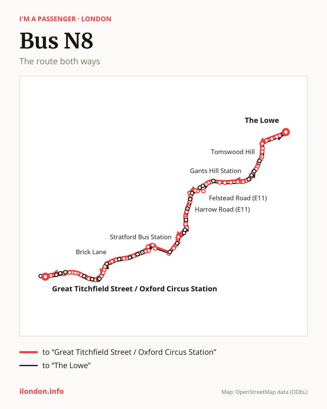
From “The Lowe” to “Great Titchfield Street / Oxford Circus Station”: 81 stops. On the way: “Tunstall Avenue”, “Staggart Green”, “Hainault Fire Station”, “Beech Grove”, “Hainault”, “Trelawney Road”, “New North Road Fullwell Cross”, “Neville Road”, “Tomswood Hill”, “Fullwell Cross”. Then “Waverley Gardens (IG6)”, “Barkingside Police Station”, “Brandville Gardens”, “Fullwood Primary School”, “Hamilton Avenue”, “Icknield Drive”, “Martley Drive”, “Gants Hill Station”, “Clarence Avenue”, “Beehive Lane Gants Hill”. Then “The Drive (IG1)”, “Redbridge Station”, “Redbridge Lane West”, “Wigram Road”, “Wanstead Station”, “Felstead Road (E11)”, “Bush Road (E11)”, “Bush Road / Green Man Rbt”, “Green Man Roundabout”, “Leytonstone Station”. Then “Harvey Road (E11)”, “Michael Road”, “Leytonstone High Road Station”, “Leytonstone Fire Station”, “Harrow Road (E11)”, “Harrow Green”, “Ranelagh Road”, “Leytonstone High Road / Thatched House”, “Janson Road”, “Chobham Road”. Then “Maryland Station”, “Manbey Grove”, “Salway Place”, “Stratford Bus Station”, “Stratford High Street / Carpenters Road”, “Warton Road”, “Abbey Lane”, “Bow Flyover”, “Roman Road Market”, “Old Ford Road (E3)”. Then “Parnell Road”, “Alice Lane”, “Ford Road (E3)”, “Medway Road (E3)”, “Haverfield Green / Grove Road”, “Bonner Street”, “Morpeth Street”, “Bethnal Green”, “Wilmot Street”, “Barnet Grove”. Then “Brick Lane”, “Shoreditch High Street Station”, “Commercial Street / Worship St”, “Primrose Street”, “Liverpool Street Station”, “Camomile Street”, “Bank Station / Cornhill”, “Poultry / Bank Station”, “Bread Street”, “St. Paul’s Station”. Before “Great Titchfield Street / Oxford Circus Station”: “City Thameslink”, “Holborn Circus”, “Holborn Circus / Fetter Lane”, “Chancery Lane”, “Brownlow Street”, “Holborn Station”, “High Holborn”, “New Oxford Street / High Holborn”, “Tottenham Court Road Station”.
On the way back the bus takes a different route, from “Holles Street” to “The Lowe” (76 stops). Only in this direction does it call at “New Oxford Street”, “Museum Street”, “Procter Street”, “King Edward Street”, “Bank Station / Poultry”, “Bishopsgate City of London”, “Threadneedle Street”, “Bethnal Grn Rd / Shoreditch High St”, “Pollard Row”, “Burnham Street”, “Smart Street”, “Roman Road / Grove Road”, “Marshgate Lane”, “Stratford H St/Carpenters Road”, “The Grove (E15)”, “Maryland Station/Manbey Grove”, “Cann Hall Road”, “West St High Rd Leytonstone”, “Vernon Rd/Leytonstone High Rd”, “Kirkdale Road”, “Cambridge Road (E11)”, “Blake Hall Road”, “Nutter Lane”, “Shere Road”, “Gantshill Crescent”, “Beattyville Gardens”, “Fremantle Road” and “Kielder Close”. Only in the direction of “Great Titchfield Street / Oxford Circus Station” does it call at, among others, “Tunstall Avenue”, “Staggart Green”, “Waverley Gardens (IG6)”, “Barkingside Police Station”, “Fullwood Primary School” and “Hamilton Avenue”. For the way back, board nearby: “Tunstall Avenue” → “The Lowe” (100 m), “Staggart Green” → “Kielder Close” (50 m), “Waverley Gardens (IG6)” → “Fremantle Road” (150 m) and “Barkingside Police Station” → “Fremantle Road” (100 m). Towards “Great Titchfield Street / Oxford Circus Station”, board nearby: “New Oxford Street” → “Tottenham Court Road Station” (50 m), “Museum Street” → “New Oxford Street / High Holborn” (50 m), “Procter Street” → “Holborn Station” (100 m) and “King Edward Street” → “St. Paul’s Station” (50 m).
Left column runs down, right column runs up. Filled stops are served both ways, dashed ones only one way: 34 towards “Great Titchfield Street / Oxford Circus Station” and 29 the other way. Tap a stop to see its name.
Connections
Shared sections with other routes: between “Shoreditch High Street Station” and “High Holborn” it shares the road with route N242; between “Bank Station / Cornhill” and “Tottenham Court Road Station” it shares the road with route N25; between “Shoreditch High Street Station” and “Poultry / Bank Station” it shares the road with route N26.
Connections by stop, in route order:
- “Manbey Grove” (only towards “Great Titchfield Street / Oxford Circus Station”): bus N86
- “Salway Place” (only towards “Great Titchfield Street / Oxford Circus Station”): bus N86
- “Stratford Bus Station”: bus N86
- “Medway Road (E3)”: bus N277
- “Haverfield Green / Grove Road” (only towards “Great Titchfield Street / Oxford Circus Station”): bus N277
- “Bethnal Green”: bus N253
- “Wilmot Street”: bus N253
- “Primrose Street”: bus N133
- “Liverpool Street Station”: buses N133 and N551
- “Camomile Street”: buses N133, N550 and N551
- “Bank Station / Cornhill”: buses N15, N21, N133, N199, N550 and N551
- “Poultry / Bank Station” (only towards “Great Titchfield Street / Oxford Circus Station”): buses N15, N21, N199, N550 and N551
- “Bread Street” (only towards “Great Titchfield Street / Oxford Circus Station”): buses N15, N21, N199, N550 and N551
- “St. Paul’s Station”: buses N15, N21, N63, N199, N550 and N551
- “City Thameslink”: buses N15, N21, N63, N89, N199, N550 and N551
- “Holborn Circus”: bus N63
- “Holborn Circus / Fetter Lane”: bus N63
- “Chancery Lane”: buses N19 and N41
- “Brownlow Street”: buses N19, N38, N41 and N98
- “Holborn Station” (only towards “Great Titchfield Street / Oxford Circus Station”): buses N1, N19, N38, N41, N68, N91, N98, N171 and N207
- “High Holborn” (only towards “Great Titchfield Street / Oxford Circus Station”): buses N1, N19, N38, N41, N68, N91, N98, N171 and N207
- “New Oxford Street / High Holborn” (only towards “Great Titchfield Street / Oxford Circus Station”): buses N1, N19, N38, N41, N68, N91, N98, N171, N207 and N253
- “Tottenham Court Road Station”: buses N1, N5, N19, N20, N29, N38, N41, N68, N73, N98, N171, N207, N253 and N279
- “Great Titchfield Street / Oxford Circus Station”: buses N3, N7, N15, N18, N22, N73, N98, N109, N113, N118, N136, N137 and N207
- “Holles Street”: buses N3, N7, N15, N18, N22, N73, N98, N109, N113, N118, N136, N137 and N207
- “New Oxford Street” (only towards “The Lowe”): buses N1, N5, N19, N20, N29, N38, N41, N68, N73, N98, N171, N207, N253 and N279
- “Museum Street” (only towards “The Lowe”): buses N1, N19, N38, N41, N68, N91, N98, N171, N207 and N253
- “Procter Street” (only towards “The Lowe”): buses N1, N19, N38, N41, N68, N91, N98, N171 and N207
- “King Edward Street” (only towards “The Lowe”): buses N15, N21, N63, N199, N550 and N551
- “Bank Station / Poultry” (only towards “The Lowe”): buses N15, N21, N199, N550 and N551
- “Bishopsgate City of London” (only towards “The Lowe”): buses N15, N21, N133, N550 and N551
- “Threadneedle Street” (only towards “The Lowe”): buses N21, N133, N550 and N551
- “Burnham Street” (only towards “The Lowe”): bus N253
- “Smart Street” (only towards “The Lowe”): bus N277
- “Roman Road / Grove Road” (only towards “The Lowe”): bus N277
- “The Grove (E15)” (only towards “The Lowe”): bus N86
Pages for these routes: bus N1, bus N109, bus N113, bus N118, bus N133, bus N136, bus N137, bus N15, bus N171, bus N18, bus N19, bus N199, bus N20, bus N207, bus N21, bus N22, bus N242, bus N25, bus N253, bus N26, bus N277, bus N279, bus N29, bus N3, bus N41, bus N5, bus N551, bus N63, bus N68, bus N7.
Passes and concessions
Which passes are available and who travels free is explained on a separate page: how to pay for public transport in London.
Questions about bus N8
Where does bus N8 start its return journey?
At “Holles Street” (350 m from “Great Titchfield Street / Oxford Circus Station”).
Where can I change from bus N8 to another bus route?
Most routes stop at “Tottenham Court Road Station” (N1, N5, N19, N20, N29, N38, N41, N68, N73, N98, N171, N207, N253 and N279) and “New Oxford Street” (only towards “The Lowe”; N1, N5, N19, N20, N29, N38, N41, N68, N73, N98, N171, N207, N253 and N279). All other stops with connections are listed above.
Checked on 4 October 2026. Source of the route and stops: Transport for London (TfL).