
Bus route N109 in London links “Fairfield Halls” and “Conduit Street / Hamleys Toy Store”. This is a night route. The return journey starts at “Oxford Circus Stn/Margaret St” (400 m from “Conduit Street / Hamleys Toy Store”) and ends at “Park Street” (100 m from “Fairfield Halls”).
The route of bus N109
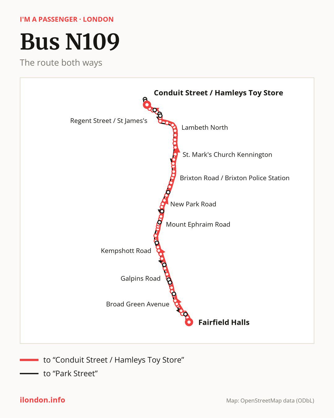
Towards “Conduit Street / Hamleys Toy Store”: 57 stops. After “Fairfield Halls”, the bus calls at “Whitgift Centre”, “West Croydon Bus Station”, “West Croydon Station”, “Montague Road”, “Sumner Road Croydon”, “Broad Green Avenue”, “Canterbury Road (CR0)”, “Croydon University Hospital”, “Thornton Heath Pond”, “Colliers Water Lane”. Then “Langdale Road”, “Galpins Road”, “Ederline Avenue Norbury”, “Tylecroft Road”, “Norbury”, “Hermitage Lane”, “Arragon Gardens”, “Kempshott Road”, “Streatham Common High Road”, “Streatham Station”. Then “St Leonard’s Church”, “Becmead Avenue”, “Kingscourt Road”, “Mount Ephraim Road”, “Streatham Hill Station / Streatham Hill”, “Barrhill Road”, “Telford Avenue”, “Christchurch Road”, “Holmewood Road”, “New Park Road”. Then “Jebb Avenue / Brixton Prison”, “Blenheim Gardens (SW2)”, “Rush Common”, “Lambeth Town Hall”, “Brixton Station”, “Brixton Road / Brixton Police Station”, “Villa Road”, “Loughborough Road”, “Groveway”, “Hillyard Street”. Then “Vassall Road (SW9)”, “St. Mark’s Church Kennington”, “Kennington Park Post Office”, “Windmill Row”, “Kennington Lane”, “Fitzalan Street”, “Kennington Road / Imperial War Museum”, “Lambeth North”, “Lower Marsh”, “St Thomas’ Hospital / County Hall”. Before “Conduit Street / Hamleys Toy Store”: “Westminster Station / Parliament Square”, “Horse Guards Parade”, “Trafalgar Square”, “Regent Street / St James’s”, “Piccadilly Circus”.
On the way back, from “Oxford Circus Stn/Margaret St” to “Park Street”: 62 stops. Only in this direction does it call at, among others, “Oxford Circus Station”, “Haymarket / Charles II Street”, “Whitehall / Trafalgar Square”, “Whitehall / Horseguards Avenue”, “Brixton Water Ln/Brixton Hill” and “Streatham Hill/Christchurch Rd”. Only in the direction of “Conduit Street / Hamleys Toy Store” does it call at, among others, “West Croydon Bus Station”, “Canterbury Road (CR0)”, “Galpins Road”, “Kempshott Road”, “Barrhill Road” and “Christchurch Road”. For the way back, board nearby: “West Croydon Bus Station” → “Poplar Walk” (100 m), “Canterbury Road (CR0)” → “Broad Green Avenue” (250 m), “Galpins Road” → “London Road / Galpins Road” (100 m) and “Kempshott Road” → “Streatham Common High Road” (250 m). Towards “Conduit Street / Hamleys Toy Store”, board nearby: “Oxford Circus Station” → “Conduit Street / Hamleys Toy Store” (250 m), “Haymarket / Charles II Street” → “Regent Street / St James’s” (150 m), “Whitehall / Trafalgar Square” → “Trafalgar Square” (200 m) and “Whitehall / Horseguards Avenue” → “Horse Guards Parade” (150 m).
Left column runs down, right column runs up. Filled stops are served both ways, dashed ones only one way: 10 towards “Conduit Street / Hamleys Toy Store” and 15 the other way. Tap a stop to see its name.
Other routes along the way
On part of the route, between “Streatham Station” and “St. Mark’s Church Kennington” it shares the road with route N133; between “Hermitage Lane” and “Brixton Station” it shares the road with route N250; between “Lambeth Town Hall” and “Kennington Road / Imperial War Museum” it shares the road with route N3.
Connections by stop, in route order:
- “Fairfield Halls”: bus N68
- “Whitgift Centre”: bus N68
- “West Croydon Bus Station” (only towards “Conduit Street / Hamleys Toy Store”): bus N68
- “West Croydon Station”: bus N68
- Stops from “Kingscourt Road” to “Streatham Hill Station / Streatham Hill”: bus N137
- “Barrhill Road” (only towards “Conduit Street / Hamleys Toy Store”): bus N137
- “Telford Avenue”: bus N137
- “Christchurch Road” (only towards “Conduit Street / Hamleys Toy Store”): bus N137
- “Holmewood Road”: bus N137
- “Rush Common”: bus N2
- “Lambeth Town Hall” (only towards “Conduit Street / Hamleys Toy Store”): bus N2
- Stops from “Brixton Station” to “Villa Road”: bus N2
- “Lower Marsh”: bus N381
- “St Thomas’ Hospital / County Hall”: bus N381
- “Westminster Station / Parliament Square”: buses N11, N26, N44, N87 and N381
- “Horse Guards Parade”: buses N5, N11, N18, N20, N26, N44, N87, N91, N97, N113, N118, N343 and N381
- “Trafalgar Square”: buses N5, N9, N11, N15, N18, N20, N21, N26, N29, N41, N44, N87, N89, N91, N97, N113, N118, N199, N279, N343, N381, N550 and N551
- “Regent Street / St James’s” (only towards “Conduit Street / Hamleys Toy Store”): buses N9, N15, N18, N19, N38, N97, N113, N118, N550 and N551
- “Piccadilly Circus”: buses N9, N15, N18, N19, N38, N97, N113 and N118
- “Conduit Street / Hamleys Toy Store”: buses N8, N15, N18, N22, N25, N55, N73, N98, N113, N118 and N207
- “Oxford Circus Stn/Margaret St”: buses N7, N8, N15, N18, N22, N25, N55, N73, N98, N113, N118, N137 and N207
- “Oxford Circus Station” (only towards “Park Street”): buses N7, N8, N15, N18, N22, N25, N55, N73, N98, N113, N118, N137 and N207
- “Haymarket / Charles II Street” (only towards “Park Street”): buses N5, N9, N15, N18, N19, N20, N29, N38, N41, N97, N113, N118, N279, N550 and N551
- “Whitehall / Trafalgar Square” (only towards “Park Street”): buses N5, N9, N11, N15, N18, N20, N21, N26, N29, N41, N44, N87, N89, N91, N97, N113, N118, N199, N279, N343, N381, N550 and N551
- “Whitehall / Horseguards Avenue” (only towards “Park Street”): buses N5, N9, N11, N15, N18, N20, N26, N29, N41, N44, N87, N91, N97, N113, N118, N199, N279, N343, N381, N550 and N551
- “Brixton Water Ln/Brixton Hill” (only towards “Park Street”): bus N2
- “Streatham Hill/Christchurch Rd” (only towards “Park Street”): bus N137
- “Leigham Court Road” (only towards “Park Street”): bus N137
- “Poplar Walk” (only towards “Park Street”): bus N68
- “Park Street”: bus N68
Pages for these routes: bus N15, bus N20.
Passes and concessions
Our page “How to pay for public transport in London” describes tickets, passes and concessions, including any differences between modes of transport.
Questions and answers
Where does bus N109 start its return journey?
At “Oxford Circus Stn/Margaret St” (400 m from “Conduit Street / Hamleys Toy Store”).
Where can I change from bus N109 to another bus route?
Most routes stop at “Trafalgar Square” (N5, N9, N11, N15, N18, N20, N21, N26, N29, N41, N44, N87, N89, N91, N97, N113, N118, N199, N279, N343, N381, N550 and N551) and “Whitehall / Trafalgar Square” (only towards “Park Street”; N5, N9, N11, N15, N18, N20, N21, N26, N29, N41, N44, N87, N89, N91, N97, N113, N118, N199, N279, N343, N381, N550 and N551). All other stops with connections are listed above.
Checked on 24 September 2026. Source of the route and stops: Transport for London (TfL).