
Bus route N68 in London goes from “Old Coulsdon / Tudor Rose” to “St Giles High Street”. This is a night route. The return journey starts at “New Oxford Street” (150 m from “St Giles High Street”).
Where bus N68 goes
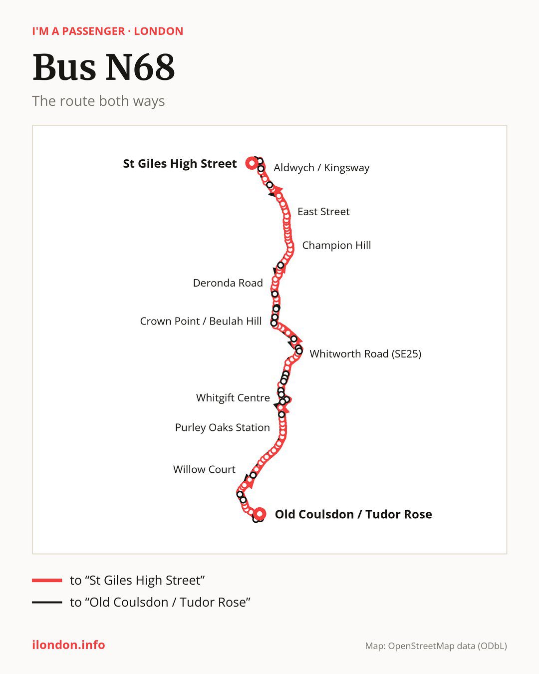
Towards “St Giles High Street”: 94 stops. After “Old Coulsdon / Tudor Rose”, the bus calls at “Mead Way / Tollers Lane”, “New Hill”, “Mead Way / Chaldon Way”, “Bradmore Way”, “Chaldon Way Gardens”, “Coulsdon South”, “Coulsdon Library”, “Coulsdon Town”, “The Avenue Coulsdon”, “Willow Court”. Then “Smitham Downs Road”, “Brighton Road / Old Lodge Lane”, “Grovelands Road (CR8)”, “Purley Tesco”, “Purley / Downlands Precinct”, “Christchurch Road / Purley Hospital”, “Montpelier Road”, “Brighton Road / Purley Downs Road”, “Biddulph Road”, “Purley Oaks Station”. Then “Sanderstead Road”, “South Croydon Bus Garage”, “Haling Park Road”, “Upland Road Croydon”, “Swan & Sugar Loaf”, “Coombe Road”, “Croydon Flyover”, “Fairfield Halls”, “East Croydon Rail Station”, “Whitgift Centre”. Then “Delta Point / West Croydon Station”, “Bedford Hall”, “Hogarth Crescent”, “Devonshire Road (CR0)”, “The Crescent Selhurst”, “Pawsons Road”, “Talbot Road Thornton Heath”, “Clifton Road (SE25)”, “Selhurst Park Stadium”, “Whitworth Road (SE25)”. Then “Howden Road (SE25)”, “Wharncliffe Gardens”, “Grange Avenue (SE25)”, “S Norwood Hill / All Saints Ch”, “Upper Beulah Hill”, “Beulah Spa”, “Hermitage Road Norwood”, “Convent Hill”, “Biggin Hill”, “Crown Point / Beulah Hill”. Then “Crown Point / Knights Hill”, “Lakeview Road”, “West Norwood Fire Station”, “St Julian’s Farm Road”, “West Norwood Station”, “Norwood Road / Robson Road”, “Lancaster Avenue (SE27)”, “Tulse Hill Station”, “Thurlow Park Road”, “Deronda Road”. Then “Brockwell Park Gardens”, “Rosendale Road”, “Brockwell Park”, “Herne Hill Station”, “Hollingbourne Road”, “Frankfurt Road”, “Herne Hill Road”, “Deepdene Road Herne Hill”, “Blanchedowne”, “Champion Hill”. Then “King’s College Hospital”, “Coldharbour Lane”, “Denmark Hill/Camberwell Green”, “Camberwell Green”, “Medlar Street”, “Wyndham Road / Camberwell Road”, “Bowyer Place”, “Camberwell Road / Albany Road”, “Westmoreland Road”, “East Street”. Then “Larcom Street”, “Heygate Street”, “Elephant & Castle Station”, “Elephant & Castle / London Road”, “St George’s Circus”, “The Old Vic”, “Waterloo Station / Tenison Way”, “Waterloo Bridge / South Bank”, “Lancaster Place”, “Aldwych / Kingsway”. Before “St Giles High Street”: “Holborn Station”, “Drury Lane”.
On the way back the bus takes a different route, from “New Oxford Street” to “Old Coulsdon / Tudor Rose” (99 stops). Only in this direction does it call at “Museum Street”, “Kingsway / Holborn Station”, “Aldwych / Drury Lane”, “Waterloo Station / Waterloo Road”, “St Paul’s Church (SE24)”, “Elmcourt Road Tulse Hill”, “Norwood Bus Garage”, “Rothschild Street”, “Furneaux Avenue”, “Grecian Crescent”, “Beulah Hill/All Saints Church”, “Ross Road”, “Nugent Road”, “Beaconsfield Road / Legacy Youth Zone”, “Northcote Road / Legacy Youth Zone”, “Cromwell Road (CR0)”, “St Mary’s Church / West Croydon”, “Lunar House”, “Dingwall Road / East Croydon Station”, “Park Street”, “Aberdeen Road South Croydon”, “Musgrove Close”, “Lion Green Road”, “Downs Road”, “Tollers Lane / Placehouse Lane”, “Tollers Lane / The Crossways” and “The Crossways”. Only in the direction of “St Giles High Street” does it call at, among others, “Mead Way / Tollers Lane”, “The Avenue Coulsdon”, “Christchurch Road / Purley Hospital”, “Fairfield Halls”, “Delta Point / West Croydon Station” and “Bedford Hall”. For the way back, board nearby: “Mead Way / Tollers Lane” → “Tollers Lane / Placehouse Lane” (100 m), “The Avenue Coulsdon” → “Willow Court” (150 m), “Christchurch Road / Purley Hospital” → “Purley / Downlands Precinct” (250 m) and “Fairfield Halls” → “Park Street” (100 m). Towards “St Giles High Street”, board nearby: “Museum Street” → “Drury Lane” (150 m), “Kingsway / Holborn Station” → “Holborn Station” (50 m), “Aldwych / Drury Lane” → “Aldwych / Kingsway” (100 m) and “Waterloo Station / Waterloo Road” → “The Old Vic” (200 m).
Left column runs down, right column runs up. Filled stops are served both ways, dashed ones only one way: 23 towards “St Giles High Street” and 28 the other way. Tap a stop to see its name.
Where to change
On part of the route, between “Camberwell Green” and “Drury Lane” it shares the road with route N171; between “Camberwell Green” and “St George’s Circus” it shares the road with route N89; between “Elephant & Castle / London Road” and “Drury Lane” it shares the road with route N1.
Connections by stop, in route order:
- “Croydon Flyover”: buses N109 and N250
- “Fairfield Halls” (only towards “St Giles High Street”): buses N109 and N250
- “East Croydon Rail Station”: buses N109 and N250
- “Whitgift Centre”: buses N109 and N250
- “Delta Point / West Croydon Station” (only towards “St Giles High Street”): buses N109 and N250
- “Bedford Hall” (only towards “St Giles High Street”): buses N109 and N250
- “Crown Point / Beulah Hill”: bus N137
- “Crown Point / Knights Hill” (only towards “St Giles High Street”): bus N137
- “Lakeview Road” (only towards “St Giles High Street”): bus N137
- Stops from “Rosendale Road” to “Herne Hill Station”: bus N3
- “Coldharbour Lane”: bus N136
- “Denmark Hill/Camberwell Green”: bus N136
- “Camberwell Green” (only towards “St Giles High Street”): bus N136
- “Medlar Street”: bus N136
- “Larcom Street”: bus N343
- “Heygate Street” (only towards “St Giles High Street”): buses N133, N155 and N343
- “Elephant & Castle Station”: buses N53, N63, N133, N155 and N343
- “Elephant & Castle / London Road”: buses N53, N63, N133, N155 and N343
- “St George’s Circus”: buses N53, N63 and N155
- “The Old Vic”: buses N53, N63 and N155
- “Waterloo Station / Tenison Way” (only towards “St Giles High Street”): buses N343 and N381
- “Waterloo Bridge / South Bank”: buses N343 and N381
- “Lancaster Place” (only towards “St Giles High Street”): buses N9, N15, N21, N26, N44, N87, N91, N155, N199, N343, N550 and N551
- “Aldwych / Kingsway” (only towards “St Giles High Street”): buses N9, N15, N21, N26, N44, N87, N91, N155, N199, N343, N550 and N551
- “Holborn Station” (only towards “St Giles High Street”): buses N8, N19, N25, N38, N41, N55, N91, N98, N207 and N242
- “Drury Lane” (only towards “St Giles High Street”): buses N8, N19, N25, N38, N41, N55, N91, N98, N207, N242 and N253
- “St Giles High Street”: buses N5, N8, N19, N20, N25, N29, N38, N41, N55, N73, N98, N207, N242, N253 and N279
- “New Oxford Street”: buses N5, N8, N19, N20, N25, N29, N38, N41, N55, N73, N98, N207, N242, N253 and N279
- “Museum Street” (only towards “Old Coulsdon / Tudor Rose”): buses N8, N19, N25, N38, N41, N55, N91, N98, N207, N242 and N253
- “Kingsway / Holborn Station” (only towards “Old Coulsdon / Tudor Rose”): buses N8, N19, N25, N38, N41, N55, N91, N98, N207 and N242
- “Aldwych / Drury Lane” (only towards “Old Coulsdon / Tudor Rose”): buses N9, N15, N21, N26, N44, N87, N91, N155, N199, N343, N550 and N551
- “Waterloo Station / Waterloo Road” (only towards “Old Coulsdon / Tudor Rose”): buses N343 and N381
- “St Paul’s Church (SE24)” (only towards “Old Coulsdon / Tudor Rose”): bus N3
- “Furneaux Avenue” (only towards “Old Coulsdon / Tudor Rose”): bus N137
- “Grecian Crescent” (only towards “Old Coulsdon / Tudor Rose”): bus N137
- Stops from “St Mary’s Church / West Croydon” to “Park Street” (only towards “Old Coulsdon / Tudor Rose”): buses N109 and N250
Pages for these routes: bus N1, bus N109, bus N133, bus N136, bus N137, bus N15, bus N155, bus N171, bus N19, bus N199, bus N20, bus N207, bus N21, bus N242, bus N25, bus N250, bus N253, bus N26, bus N279, bus N29, bus N3, bus N343, bus N381, bus N41, bus N5, bus N53, bus N55, bus N551, bus N63.
Passes and concessions
Our page “How to pay for public transport in London” describes tickets, passes and concessions, including any differences between modes of transport.
Questions about bus N68
Where does bus N68 start its return journey?
At “New Oxford Street” (150 m from “St Giles High Street”).
Where can I change from bus N68 to another bus route?
Most routes stop at “St Giles High Street” and “New Oxford Street” (N5, N8, N19, N20, N25, N29, N38, N41, N55, N73, N98, N207, N242, N253 and N279). All other stops with connections are listed above.
Checked on 30 September 2026. Source of the route and stops: Transport for London (TfL).