

Bus route K3 in London goes from “Roehampton Vale Asda” to “High Street”.
Which way bus K3 runs
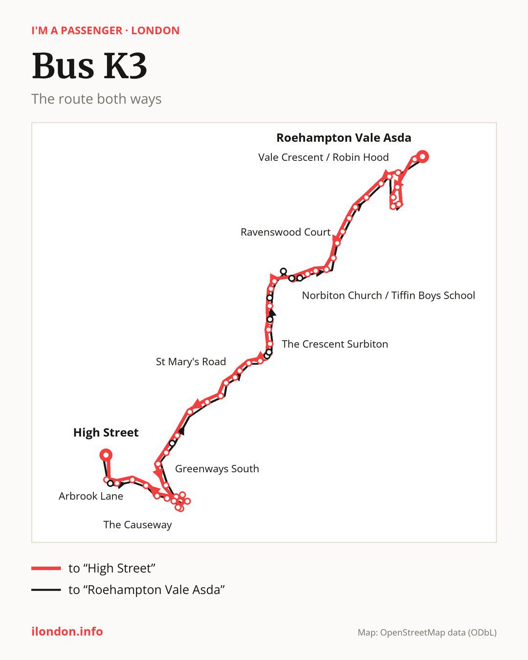
From “Roehampton Vale Asda” to “High Street”: 52 stops. On the way: “Roehampton Vale Campus”, “Windermere Road (SW15)”, “Bowness Crescent”, “Keswick Avenue”, “Grasmere Avenue”, “Vale Crescent / Robin Hood”, “Robin Hood Lane”, “Woodview Close / Dorich House Museum”, “Kingston University”, “Galsworthy House”. Then “Warren Road Coombe”, “Ravenswood Court”, “George Road”, “Kingston Hospital”, “Norbiton”, “Station Road (KT2)”, “Gordon Road (KT2)”, “Norbiton Church / Tiffin Boys School”, “Eden Street”, “Brook Street (KT1)”. Then “Kingston University / County Hall”, “Surbiton Crescent”, “Maple Road (KT6)”, “The Crescent Surbiton”, “Surbiton Station/Claremont Rd”, “Surbiton Station / Victoria Road”, “Surbiton Sainsbury’s”, “Electric Parade”, “Victoria Recreational Grounds”, “St Mary’s Road”. Then “Effingham Road”, “Rectory Lane”, “Mayfield Close”, “Cumberland Drive”, “Hinchley Wood Railway Station”, “Greenways South”, “Manor Road South”, “Woodbourne Drive”, “The Green”, “St Leonard’s Road”. Before “High Street”: “Common Road”, “The Causeway”, “Recreation Ground”, “Village Hall”, “Dalmore Avenue”, “Claygate Railway Station”, “Loseberry Road”, “Arbrook Lane”, “Orchard Way”, “Clare Hill”.
The return journey is different. Towards “Roehampton Vale Asda”: 54 stops. Only in this direction does it call at, among others, “Bracondale”, “Greenways North”, “Surbiton”, “Claremont Rd/ Surbiton Station”, “Surbiton Road / Penrhyn Road” and “Kingston Crown Court College”. Only in the direction of “High Street” does it call at, among others, “Roehampton Vale Campus”, “Norbiton Church / Tiffin Boys School”, “Surbiton Crescent”, “Surbiton Station/Claremont Rd”, “Surbiton Station / Victoria Road” and “Dalmore Avenue”. For the way back, board nearby: “Roehampton Vale Campus” → “Roehampton Vale Asda” (200 m), “Norbiton Church / Tiffin Boys School” → “Tiffin School / London Road” (50 m), “Surbiton Crescent” → “Surbiton Road / Penrhyn Road” (50 m) and “Surbiton Station/Claremont Rd” → “Claremont Rd/ Surbiton Station” (50 m). Towards “High Street”, board nearby: “Bracondale” → “Clare Hill” (150 m), “Greenways North” → “Hinchley Wood Railway Station” (250 m), “Surbiton” → “Surbiton Station / Victoria Road” (50 m) and “Claremont Rd/ Surbiton Station” → “Surbiton Station/Claremont Rd” (50 m).
Left column runs down, right column runs up. Filled stops are served both ways, dashed ones only one way: 7 towards “High Street” and 9 the other way. Tap a stop to see its name.
Where to change
Shared sections with other routes: between “Kingston Hospital” and “Surbiton Station/Claremont Rd” it shares the road with route K2; between “Eden Street” and “Surbiton Sainsbury’s” it shares the road with route 71; between “Robin Hood Lane” and “George Road” it shares the road with route 85.
Connections by stop, in route order:
- “Roehampton Vale Asda”: bus 265
- “Roehampton Vale Campus” (only towards “High Street”): bus 265
- Stops from “Windermere Road (SW15)” to “Robin Hood Lane”: bus 265
- “George Road”: buses 57 and 213
- “Kingston Hospital”: buses 57, 213 and K5
- “Norbiton”: buses 57, 213, 371 and K5
- “Station Road (KT2)”: buses 57, 213, 371 and K5
- “Gordon Road (KT2)”: buses 57, 131, 213, 371 and K5
- “Norbiton Church / Tiffin Boys School” (only towards “High Street”): buses 57, 65, 111, 131, 213, 216, 285, 371, 406, 418, 458, 461, 465, 481, 714, 715, K1, K5 and SL7
- “Eden Street”: buses 57, 65, 111, 131, 213, 216, 285, 371, 406, 411, 418, 458, 461, 465, 481, 714, 715, K1, K5 and SL7
- “Brook Street (KT1)”: buses 57, 65, 111, 131, 213, 216, 285, 371, 406, 411, 418, 458, 461, 465, 481, 714, 715, K1, K5 and SL7
- “Kingston University / County Hall”: buses 406, 418, 458, 465, 714 and 715
- “Surbiton Crescent” (only towards “High Street”): buses 406, 418, 458, 465, 714, 715 and K1
- “Maple Road (KT6)”: buses 406, 418, 458, 465, 714, 715 and K1
- “The Crescent Surbiton”: buses 406, 418, 465 and K1
- “Surbiton Station/Claremont Rd” (only towards “High Street”): buses 465 and K1
- “Surbiton Station / Victoria Road” (only towards “High Street”): buses 465 and K1
- “Surbiton Sainsbury’s”: buses 465 and K1
- “Electric Parade”: buses 458, 465, 714, 715 and K1
- “Cumberland Drive”: buses 458, 714 and 715
- “High Street”: buses 458, 714 and 715
- “Surbiton” (only towards “Roehampton Vale Asda”): buses 465 and K1
- “Claremont Rd/ Surbiton Station” (only towards “Roehampton Vale Asda”): buses 465 and K1
- “Surbiton Road / Penrhyn Road” (only towards “Roehampton Vale Asda”): buses 406, 418, 458, 465, 714, 715 and K1
- “Kingston Crown Court College” (only towards “Roehampton Vale Asda”): buses 65, 371, 406, 418, 458, 465, 714, 715 and K1
- “Cromwell Road Bus Station” (only towards “Roehampton Vale Asda”): buses 57, 65, 111, 131, 213, 216, 285, 371, 406, 411, 418, 458, 461, 465, 481, 714, 715, K1, K5 and SL7
- “Tiffin School / London Road” (only towards “Roehampton Vale Asda”): buses 57, 65, 111, 131, 213, 216, 285, 371, 406, 418, 458, 461, 465, 481, 714, 715, K1, K5 and SL7
- “Norbiton Church” (only towards “Roehampton Vale Asda”): buses 57, 131, 213, 371 and K5
Pages for these routes: bus K1, bus K5.
Passes and concessions
Tickets, passes and concessions are covered on a separate page: how to pay for public transport in London.
Questions and answers
Does bus K3 go to “Woodview Close / Dorich House Museum”?
Yes, in both directions.
Where can I change from bus K3 to another bus route?
Most routes stop at “Eden Street” and “Brook Street (KT1)” (57, 65, 111, 131, 213, 216, 285, 371, 406, 411, 418, 458, 461, 465, 481, 714, 715, K1, K5 and SL7). All other stops with connections are listed above.
Checked on 3 October 2026. Source of the route and stops: Transport for London (TfL).