
Bus route 216 in London runs between “Elmsleigh Bus Station” and “Cromwell Road Bus Station”. One stop is served in one direction only. The return journey starts at “Kingston Station” (300 m from “Cromwell Road Bus Station”).
Which way bus 216 runs
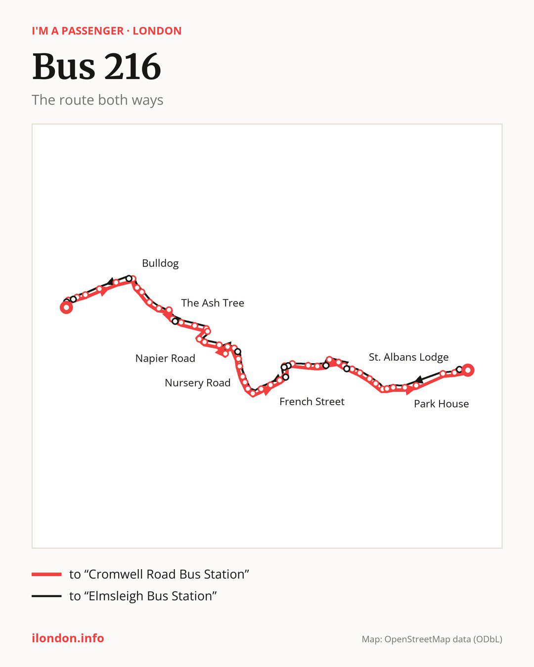
From “Elmsleigh Bus Station” to “Cromwell Road Bus Station”: 53 stops. On the way: “High Street”, “Birch Green”, “Crooked Billet Roundabout”, “Shortwood Avenue”, “Kenilworth Road”, “Bulldog”, “Salcombe Road”, “Station Crescent”, “Dudley Road”, “War Memorial”. Then “Town Tree Road”, “The Ash Tree”, “Chessholme Road”, “Elgin Avenue”, “Meadhurst Primary School”, “Saville Crescent”, “Norman Road”, “Napier Road”, “Windmill Road”, “Tesco”. Then “Spelthorne Grove”, “Sunbury Cross Shopping Centre”, “St Ignatius Church”, “Nursery Road”, “Manor Lane”, “Croysdale Avenue”, “The Three Fishes”, “Church Street”, “Orchard Meadow”, “French Street”. Then “Sunbury Court”, “Harfield Road”, “Kenton Avenue”, “Stain Hill West Reservoir”, “Stain Hill Reservoir”, “Hampton Care Nursing Home”, “Percy Road”, “Hampton”, “Hampton & Richmond Borough F C”, “Algar Court”. Then “Garrick Villa”, “St. Albans Lodge”, “St Alban’s Riverside”, “Hampton Lodge”, “Hampton Court Green”, “Hampton Court Palace”, “Chestnut Avenue / Hampton”, “Park House”, “Paddock Gates”, “Church Grove/The King’s Field”. Before “Cromwell Road Bus Station”: “Kingston / Wood Street”.
On the way back the bus takes a different route, from “Kingston Station” to “Elmsleigh Bus Station” (51 stops). Only in this direction does it call at “Hampton / Thames Street”, “Oldfield Road / Percy Road”, “Kenton Avanue”, “Bramwell Close”, “Lower Hampton Road”, “Green Street”, “Dingle Road”, “Town Lane”, “Kingston Road” and “Ripley Way”. Only in the direction of “Cromwell Road Bus Station” does it call at, among others, “High Street”, “Birch Green”, “Nursery Road”, “Harfield Road”, “Kenton Avenue” and “Stain Hill West Reservoir”. For the way back, board nearby: “High Street” → “Ripley Way” (100 m), “Birch Green” → “Kingston Road” (150 m), “Nursery Road” → “St Ignatius Church” (250 m) and “Harfield Road” → “Lower Hampton Road” (50 m). Towards “Cromwell Road Bus Station”, board nearby: “Hampton / Thames Street” → “Algar Court” (150 m), “Oldfield Road / Percy Road” → “Percy Road” (50 m), “Kenton Avanue” → “Kenton Avenue” (150 m) and “Bramwell Close” → “Kenton Avenue” (50 m).
Left column runs down, right column runs up. Filled stops are served both ways, dashed ones only one way: 13 towards “Cromwell Road Bus Station” and 11 the other way. Tap a stop to see its name.
Other routes along the way
Shared sections with other routes: between “Bulldog” and “Church Street” it shares the road with route 555; between “Hampton” and “Cromwell Road Bus Station” it shares the road with route 111; between “Hampton Court Palace” and “Cromwell Road Bus Station” it shares the road with route 461.
Connections by stop, in route order:
- “Elmsleigh Bus Station”: buses 117, 290, 446, 458 and X442
- “High Street” (only towards “Cromwell Road Bus Station”): buses 117, 290, 446, 458 and X442
- “Birch Green” (only towards “Cromwell Road Bus Station”): buses 117, 290, 446 and X442
- “Crooked Billet Roundabout”: buses 446 and X442
- “Shortwood Avenue”: bus 446
- “Kenilworth Road”: bus 446
- “Bulldog”: buses 116 and 446
- “Salcombe Road”: bus 446
- “Station Crescent”: bus 117
- “Dudley Road”: bus 117
- Stops from “War Memorial” to “The Ash Tree”: buses 117 and 290
- “Chessholme Road”: bus 290
- Stops from “Norman Road” to “Spelthorne Grove”: bus 290
- “Sunbury Cross Shopping Centre”: buses 235 and 290
- “St Ignatius Church”: bus 235
- “Nursery Road” (only towards “Cromwell Road Bus Station”): bus 235
- Stops from “Manor Lane” to “Church Street”: bus 235
- “Algar Court” (only towards “Cromwell Road Bus Station”): bus R68
- “Garrick Villa”: bus R68
- “St. Albans Lodge” (only towards “Cromwell Road Bus Station”): bus R68
- Stops from “St Alban’s Riverside” to “Hampton Court Green”: bus R68
- “Hampton Court Palace” (only towards “Cromwell Road Bus Station”): bus R68
- “Chestnut Avenue / Hampton”: bus R68
- “Church Grove/The King’s Field”: buses 281, 285 and 481
- Stops from “Kingston / Wood Street” to “Kingston Station”: buses 57, 65, 71, 85, 131, 213, 281, 285, 371, 406, 418, 458, 465, 481, 515, 714, 715, K1, K2, K3, K4, K5 and SL7
- “Hampton / Thames Street” (only towards “Elmsleigh Bus Station”): bus R68
- “Green Street” (only towards “Elmsleigh Bus Station”): buses 235 and 290
- “Dingle Road” (only towards “Elmsleigh Bus Station”): bus 290
- “Town Lane” (only towards “Elmsleigh Bus Station”): buses 116 and 446
- “Kingston Road” (only towards “Elmsleigh Bus Station”): buses 117, 290, 446 and X442
- “Ripley Way” (only towards “Elmsleigh Bus Station”): buses 117, 290, 446, 458 and X442
Pages for these routes: bus K1, bus K2, bus K3, bus K4, bus K5, bus R68, bus SL7, bus X442, bus 57, bus 65, bus 71, bus 85, bus 111, bus 116, bus 117, bus 131.
Passes and concessions
Tickets, passes and concessions are covered on a separate page: how to pay for public transport in London.
Questions and answers
Where does bus 216 start its return journey?
At “Kingston Station” (300 m from “Cromwell Road Bus Station”).
Where can I change from bus 216 to another bus route?
Most routes stop at “Kingston / Wood Street” and “Cromwell Road Bus Station” (57, 65, 71, 85, 131, 213, 281, 285, 371, 406, 418, 458, 465, 481, 515, 714, 715, K1, K2, K3, K4, K5 and SL7). All other stops with connections are listed above.
Checked on 3 October 2026. Source of the route and stops: Transport for London (TfL).