
Bus route N98 in London runs between “Stanmore Station” and “Red Lion Square”. This is a night route.
Which way bus N98 runs
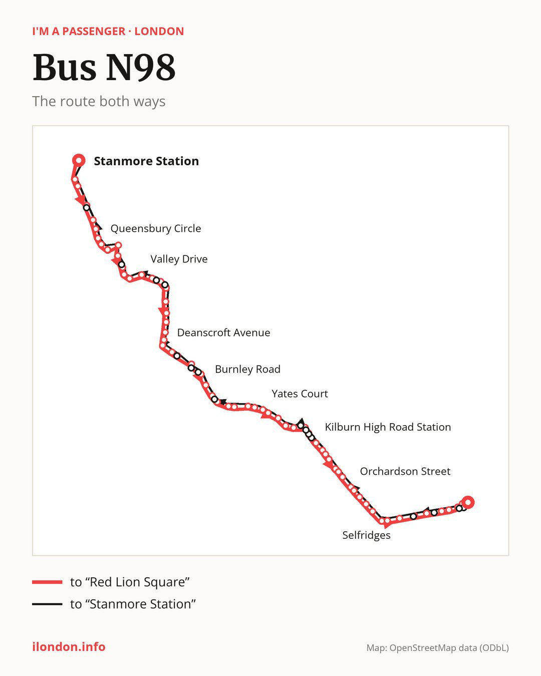
From “Stanmore Station” to “Red Lion Square”: 64 stops. On the way: “Nelson Road”, “Canons Park Open Space”, “Wemborough Road”, “Wigton Gardens”, “Broadcroft Avenue”, “Taunton Way”, “Queensbury Circle”, “The Honeypot”, “Queensbury”, “Queensbury Morrisons”. Then “Princes Avenue (NW9)”, “Kingsbury Circle”, “Kingsbury Station”, “Valley Drive”, “Roe Green Park”, “Kingsbury Road / Roe Green”, “Kingsbury Green”, “Slough Lane”, “Queensbury Road”, “Lavender Avenue (NW9)”. Then “Deanscroft Avenue”, “Tudor Gardens Kingsbury”, “Blackbird Hill”, “Quainton Street”, “Press Road”, “Neasden Shopping Parade”, “Mulgrave Road”, “Burnley Road”, “Chapter Road Dollis Hill”, “Willesden Bus Garage”. Then “Villiers Road”, “Willesden Green Library”, “Walm Lane”, “Sidmouth Road”, “Yates Court”, “Deerhurst Road (NW2)”, “Christchurch (NW6)”, “Plympton Avenue”, “Kingsley Road (NW6)”, “Kingsgate Place”. Then “Quex Road”, “Kilburn High Road Station”, “Kilburn Park Road”, “Carlton Vale”, “Elgin Avenue / Maida Vale Stn”, “Hall Road”, “Sutherland Avenue Maida Vale”, “St Johns Wood Road”, “Orchardson Street”, “Church Street Market”. Then “Edgware Road (Bakerloo line) Station”, “Sussex Gardens”, “George Street (W2)”, “Marble Arch Station / Edgware Road”, “Marble Arch”, “Selfridges”, “Oxford Circus Station / John Lewis”, “Great Titchfield Street / Oxford Circus Station”, “Tottenham Court Road Station”, “New Oxford Street”. Before “Red Lion Square”: “Museum Street”, “Bloomsbury Square”.
On the way back the bus takes a different route, from “Red Lion Square” to “Stanmore Station” (65 stops). Only in this direction does it call at “High Holborn”, “New Oxford Street / High Holborn”, “Wardour Street”, “Oxford Street / John Lewis”, “Brondesbury Road (NW6)”, “Kilburn High Road”, “Priory Park Road”, “Willesden Lane Kilburn”, “Meyrick Road”, “Clifford Way”, “Neasden Underpass”, “Aylesbury Street (NW10)”, “Kingsbury / Pipers Green”, “Slough Lane / Roe Green”, “Cowbridge Road” and “Honeypot Lane Centre”. Only in the direction of “Red Lion Square” does it call at, among others, “Wemborough Road”, “Taunton Way”, “Princes Avenue (NW9)”, “Roe Green Park”, “Kingsbury Road / Roe Green” and “Press Road”. For the way back, board nearby: “Wemborough Road” → “Honeypot Lane Centre” (50 m), “Taunton Way” → “Queensbury Circle” (250 m), “Princes Avenue (NW9)” → “Cowbridge Road” (100 m) and “Roe Green Park” → “Slough Lane / Roe Green” (150 m). Towards “Red Lion Square”, board nearby: “High Holborn” → “Bloomsbury Square” (150 m), “New Oxford Street / High Holborn” → “Museum Street” (50 m), “Wardour Street” → “Tottenham Court Road Station” (250 m) and “Oxford Street / John Lewis” → “Oxford Circus Station / John Lewis” (50 m).
Left column runs down, right column runs up. Filled stops are served both ways, dashed ones only one way: 15 towards “Red Lion Square” and 16 the other way. Tap a stop to see its name.
Where to change
Shared sections with other routes: between “Kingsgate Place” and “Edgware Road (Bakerloo line) Station” it shares the road with route N32; between “Marble Arch” and “Bloomsbury Square” it shares the road with route N207; between “Sussex Gardens” and “Oxford Circus Station / John Lewis” it shares the road with route N7.
Connections by stop, in route order:
- Stops from “Chapter Road Dollis Hill” to “Sidmouth Road”: bus N266
- “Quex Road” (only towards “Red Lion Square”): buses N28 and N31
- “Kilburn High Road Station”: buses N28 and N31
- “Kilburn Park Road”: buses N28 and N31
- “Church Street Market”: buses N18 and N118
- “Edgware Road (Bakerloo line) Station”: buses N18, N27, N118 and N205
- “Sussex Gardens”: buses N18, N27, N118 and N205
- “George Street (W2)”: buses N27 and N205
- “Marble Arch Station / Edgware Road”: buses N2, N74 and N137
- “Marble Arch”: buses N2, N74, N113 and N137
- “Selfridges”: buses N2, N74, N113 and N137
- “Oxford Circus Station / John Lewis” (only towards “Red Lion Square”): buses N3, N15, N18, N22, N55, N73, N109, N113, N118, N136 and N137
- “Great Titchfield Street / Oxford Circus Station”: buses N3, N15, N18, N22, N55, N73, N109, N113, N118, N136 and N137
- “Tottenham Court Road Station”: buses N1, N5, N19, N20, N29, N38, N41, N55, N68, N73, N171, N242, N253 and N279
- “New Oxford Street” (only towards “Red Lion Square”): buses N1, N5, N19, N20, N29, N38, N41, N55, N68, N73, N171, N242, N253 and N279
- “Museum Street” (only towards “Red Lion Square”): buses N1, N19, N38, N41, N55, N68, N91, N171, N242 and N253
- “Bloomsbury Square” (only towards “Red Lion Square”): buses N1, N19, N38, N41, N55, N68, N91, N171 and N242
- “Red Lion Square”: buses N1, N19, N38, N41, N55, N68, N91, N171 and N242
- “High Holborn” (only towards “Stanmore Station”): buses N1, N19, N38, N41, N55, N68, N91, N171 and N242
- “New Oxford Street / High Holborn” (only towards “Stanmore Station”): buses N1, N19, N38, N41, N55, N68, N91, N171, N242 and N253
- “Wardour Street” (only towards “Stanmore Station”): buses N5, N20, N29, N55, N73, N253 and N279
- “Oxford Street / John Lewis” (only towards “Stanmore Station”): buses N3, N15, N18, N22, N109, N113, N118, N136 and N137
- “Brondesbury Road (NW6)” (only towards “Stanmore Station”): buses N28 and N31
- “Kilburn High Road” (only towards “Stanmore Station”): buses N28 and N31
- “Meyrick Road” (only towards “Stanmore Station”): bus N266
Pages for these routes: bus N1, bus N109, bus N113, bus N118, bus N136, bus N137, bus N15, bus N171, bus N18, bus N19, bus N2, bus N20, bus N205, bus N207, bus N22, bus N242, bus N253, bus N266, bus N27, bus N279, bus N28, bus N29, bus N3, bus N31, bus N32, bus N38, bus N41, bus N5, bus N55, bus N68, bus N7, bus N74, bus N91.
Passes and concessions
Our page “How to pay for public transport in London” describes tickets, passes and concessions, including any differences between modes of transport.
Questions about bus N98
Does bus N98 go to “Canons Park Open Space”?
Yes, in both directions.
Where can I change from bus N98 to another bus route?
Most routes stop at “Tottenham Court Road Station” (N1, N5, N19, N20, N29, N38, N41, N55, N68, N73, N171, N242, N253 and N279) and “New Oxford Street” (only towards “Red Lion Square”; N1, N5, N19, N20, N29, N38, N41, N55, N68, N73, N171, N242, N253 and N279). All other stops with connections are listed above.
Checked on 3 October 2026. Source of the route and stops: Transport for London (TfL).