
Bus route 169 in London links “Clayhall / The Glade” and “North Street”. The return journey starts at “Barking Town Centre” (150 m from “North Street”).
Where bus 169 goes
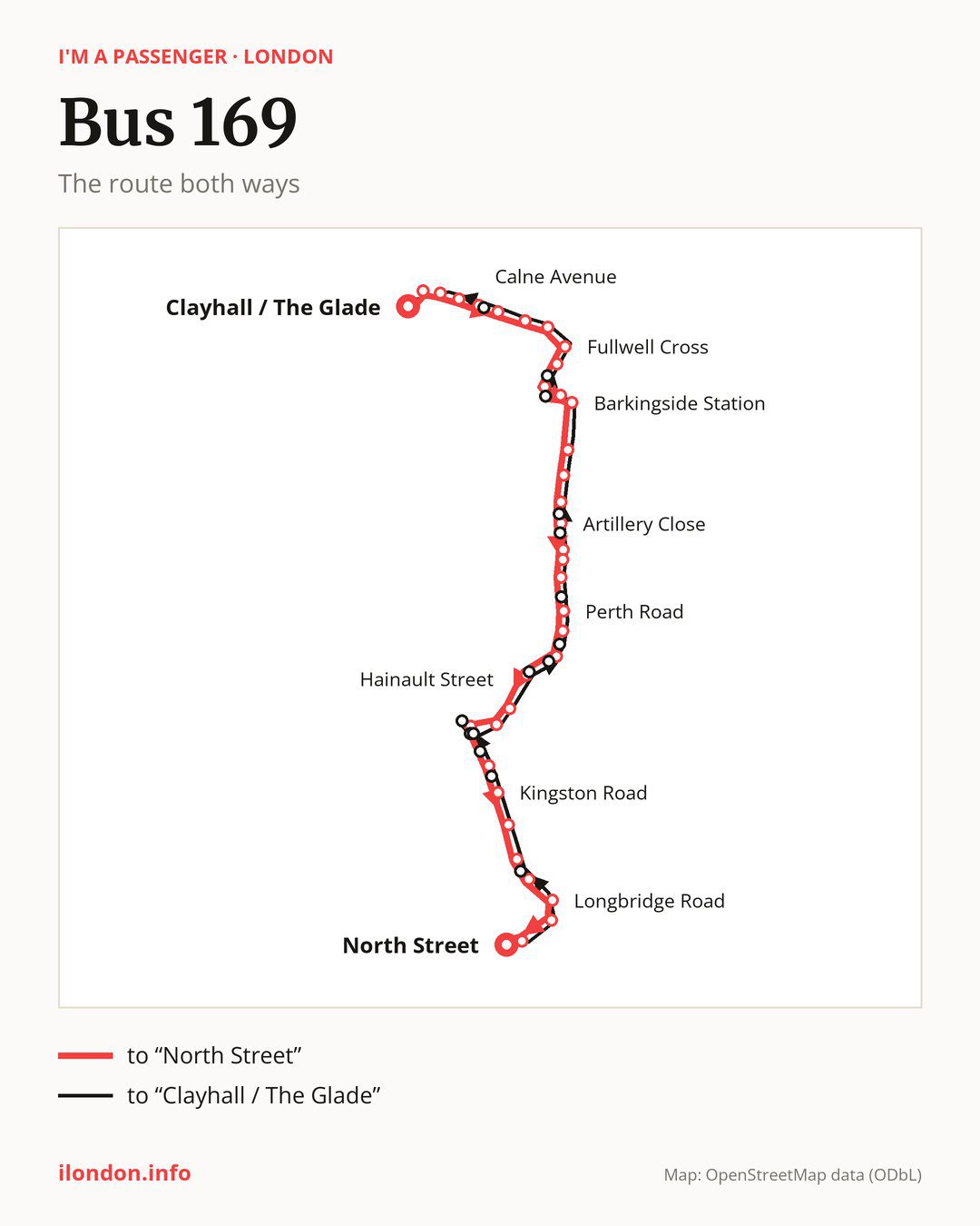
From “Clayhall / The Glade” to “North Street”: 36 stops. On the way: “Owen Waters House”, “Copper Beech Close”, “Caterham Avenue”, “Calne Avenue”, “Ravensbourne Gardens”, “Mossford Lane Fulwell Cross”, “Aintree Crescent”, “Fullwell Cross”, “Waverley Gardens (IG6)”, “Barkingside Police Station”. Then “Sandringham Gardens”, “Barkingside Station”, “Princes Road Barkingside”, “Aldwych Avenue”, “Hamilton Avenue Newbury Park”, “Artillery Close”, “Eastern Avenue (IG2)”, “Clifton Road (IG2)”, “Parklands Close”, “Perth Road”. Then “Benton Road”, “Jaffe Road”, “Griggs Approach”, “Hainault Street”, “Redbridge Central Library”, “Ilford / Chapel Road”, “Dudley Road Ilford”, “Kingston Road”, “Wingate Road”, “Loxford Polyclinic”. Before “North Street”: “Park Avenue (IG11)”, “Longbridge Road”, “Barking Station”, “Barking Town Centre”.
On the way back the bus takes a different route, from “Barking Town Centre” to “Clayhall / The Glade” (36 stops). Only in this direction does it call at “Victoria Road (IG11)”, “Clementswood Baptist Church”, “Bengal Road”, “Ilford Sainsbury’s”, “Ilford Station / Ilford Hill”, “Pioneer Point”, “Christchurch Road (IG1)”, “Brisbane Road”, “Vicarage Lane Ilford”, “Ley Street / Perth Road”, “Perrymans Farm Road”, “Emmott Avenue”, “Barkingside Magistrates Court”, “Fremantle Road” and “Basildon Avenue”. Only in the direction of “North Street” does it call at, among others, “Owen Waters House”, “Calne Avenue”, “Waverley Gardens (IG6)”, “Barkingside Police Station”, “Sandringham Gardens” and “Artillery Close”. For the way back, board nearby: “Owen Waters House” → “Copper Beech Close” (200 m), “Calne Avenue” → “Basildon Avenue” (50 m), “Waverley Gardens (IG6)” → “Fremantle Road” (150 m) and “Barkingside Police Station” → “Barkingside Magistrates Court” (100 m). Towards “North Street”, board nearby: “Victoria Road (IG11)” → “Park Avenue (IG11)” (100 m), “Clementswood Baptist Church” → “Dudley Road Ilford” (100 m), “Bengal Road” → “Dudley Road Ilford” (150 m) and “Ilford Sainsbury’s” → “Ilford / Chapel Road” (100 m).
Left column runs down, right column runs up. Filled stops are served both ways, dashed ones only one way: 15 towards “North Street” and 15 the other way. Tap a stop to see its name.
Connections
Shared sections with other routes: between “Ilford / Chapel Road” and “Barking Station” it shares the road with route EL1; between “Loxford Polyclinic” and “North Street” it shares the road with route 366.
Connections by stop, in route order:
- “Mossford Lane Fulwell Cross”: bus 275
- “Aintree Crescent”: buses 150, 167, 247, 275 and 462
- “Fullwell Cross”: buses 128, 150, 167, 247, 275 and 462
- Stops from “Waverley Gardens (IG6)” to “Sandringham Gardens” (only towards “North Street”): buses 128, 150, 167, 247, 275 and 462
- “Barkingside Station”: buses 128, 150, 167, 247 and 275
- “Princes Road Barkingside”: buses 247 and 275
- “Artillery Close” (only towards “North Street”): buses 66, 296, 396 and SL12
- “Eastern Avenue (IG2)”: buses 66, 296, 364, 396 and SL12
- “Clifton Road (IG2)” (only towards “North Street”): buses 66, 296, 364, 396 and SL12
- “Parklands Close”: buses 66, 296, 364, 396 and SL12
- “Perth Road” (only towards “North Street”): bus 364
- “Benton Road”: bus 364
- “Jaffe Road” (only towards “North Street”): bus 86
- “Griggs Approach” (only towards “North Street”): buses 86, 123, 128, 145, 150, 167, 179, 364 and 462
- “Hainault Street”: buses 25, 86, 123, 128, 145, 147, 150, 167, 179, 364, 425, 462 and W19
- “Redbridge Central Library”: buses 25, 86, 123, 128, 145, 147, 150, 167, 179, 296, 364, 396, 425, 462, SL2 and W19
- “Ilford / Chapel Road” (only towards “North Street”): buses 25, 86, 123, 128, 145, 147, 150, 167, 179, 296, 364, 396, 425, 462, SL2 and W19
- Stops from “Longbridge Road” to “North Street”: buses 5, 62, 238, 287, 368, EL2, EL3 and SL2
- Stops from “Bengal Road” to “Pioneer Point” (only towards “Clayhall / The Glade”): buses 25, 86, 123, 128, 145, 147, 150, 167, 179, 296, 364, 396, 425, 462, SL2 and W19
- “Christchurch Road (IG1)” (only towards “Clayhall / The Glade”): buses 86, 128, 145 and 150
- “Brisbane Road” (only towards “Clayhall / The Glade”): bus 86
- “Ley Street / Perth Road” (only towards “Clayhall / The Glade”): bus 364
- “Perrymans Farm Road” (only towards “Clayhall / The Glade”): buses 66, 296, 396 and SL12
- “Barkingside Magistrates Court” (only towards “Clayhall / The Glade”): buses 128, 150, 167, 247, 275 and 462
- “Fremantle Road” (only towards “Clayhall / The Glade”): buses 128, 150, 167, 247, 275 and 462
Pages for these routes: bus EL1, bus EL2, bus EL3, bus SL12, bus SL2, bus W19, bus 5, bus 25, bus 62, bus 66, bus 86, bus 123, bus 128, bus 145, bus 147, bus 150, bus 167, bus 179.
Passes and concessions
Tickets, passes and concessions are covered on a separate page: how to pay for public transport in London.
Questions and answers
Where does bus 169 start its return journey?
At “Barking Town Centre” (150 m from “North Street”).
Where can I change from bus 169 to another bus route?
Most routes stop at “Redbridge Central Library” (25, 86, 123, 128, 145, 147, 150, 167, 179, 296, 364, 396, 425, 462, SL2 and W19) and “Ilford / Chapel Road” (only towards “North Street”; 25, 86, 123, 128, 145, 147, 150, 167, 179, 296, 364, 396, 425, 462, SL2 and W19). All other stops with connections are listed above.
Checked on 30 September 2026. Source of the route and stops: Transport for London (TfL).