
Bus route 275 in London links “St James Street Station” and “Barkingside Tesco”. One stop is served in one direction only.
The route of bus 275
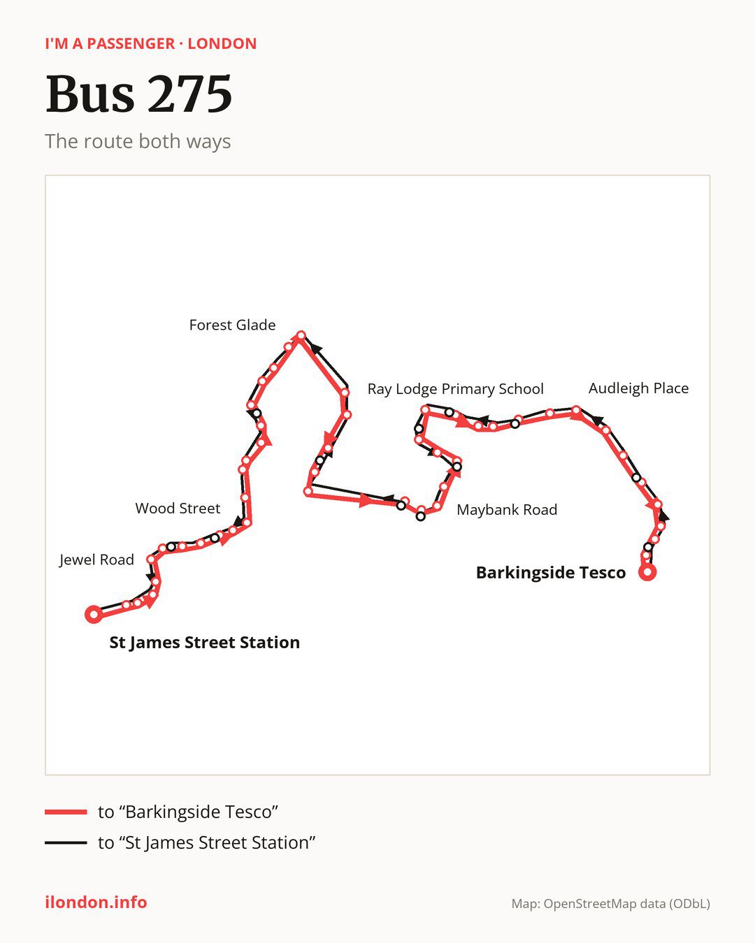
Towards “Barkingside Tesco”: 48 stops. After “St James Street Station”, the bus calls at “Selborne Walk / Vernon Road”, “Selborne Walk”, “Walthamstow Bus Station”, “Walthamstow Market Walthamstow”, “Jewel Road”, “Forest Road / The Bell”, “Waltham Forest Town Hall”, “Waltham Forest College”, “St John’s Road”, “Wood Street”. Then “Forest Road Upper Walthamstow”, “Thorpe Hall Road”, “Southend Road”, “Wadham Road Hale End”, “Forest Mount Road”, “Hollywood Way”, “Highams Park Station”, “Richmond Avenue Highams Park”, “Sunnydene Avenue”, “Forest Glade”. Then “Chingford Lane (E4)”, “Mill Lane”, “St Aubyns School”, “Chelmsford Rd/Woodford New Rd”, “Waterworks Corner”, “Maybank Road South Woodford”, “Charlie Browns Roundabout”, “Raven Road”, “Maybank Road”, “Broadmead Road / Chigwell Road”. Then “Orchard Estate”, “Spring Gardens Woodford”, “Woodford”, “Ray Lodge Primary School”, “Chigwell Road”, “Ashton Playing Fields”, “Manor Road (IG8)”, “Cross Road (IG8)”, “Audleigh Place”, “Stradbroke Park”. Before “Barkingside Tesco”: “Wannock Gardens”, “Kingsley Road (IG6)”, “Fencepiece Road”, “Fullwell Cross”, “Waverley Gardens (IG6)”, “Barkingside Police Station”.
On the way back the bus takes a different route, from “Barkingside Tesco” to “St James Street Station” (46 stops). Only in this direction does it call at “Fremantle Road”, “Benrek Close”, “Roding Lane North”, “Greenstead Avenue”, “St. Anthony’s Avenue”, “Broadmead Road Woodford Bridge”, “Chigwell Road / South Woodford”, “Mulberry Way”, “Oak Hill”, “Beverley Road (E4)”, “Thorpe Coombe Hospital” and “Hoe Street / The Bell”. Only in the direction of “Barkingside Tesco” does it call at, among others, “Selborne Walk / Vernon Road”, “Forest Road / The Bell”, “Waltham Forest College”, “St John’s Road”, “Forest Mount Road” and “Forest Glade”. For the way back, board nearby: “Selborne Walk / Vernon Road” → “Selborne Walk” (150 m), “Forest Road / The Bell” → “Hoe Street / The Bell” (100 m), “Waltham Forest College” → “Thorpe Coombe Hospital” (200 m) and “St John’s Road” → “Thorpe Coombe Hospital” (100 m). Towards “Barkingside Tesco”, board nearby: “Fremantle Road” → “Barkingside Police Station” (100 m), “Benrek Close” → “Kingsley Road (IG6)” (100 m), “Roding Lane North” → “Manor Road (IG8)” (50 m) and “Greenstead Avenue” → “Ray Lodge Primary School” (100 m).
Left column runs down, right column runs up. Filled stops are served both ways, dashed ones only one way: 14 towards “Barkingside Tesco” and 12 the other way. Tap a stop to see its name.
Connections
On part of the route, between “Charlie Browns Roundabout” and “Woodford” it shares the road with route W14; between “Chingford Lane (IG8)” and “Waterworks Corner” it shares the road with route 20; between “Waltham Forest Town Hall” and “Wood Street” it shares the road with route 123.
Connections by stop, in route order:
- “St James Street Station”: buses 58, 158, 212 and W19
- “Selborne Walk / Vernon Road” (only towards “Barkingside Tesco”): buses 34, 58, 212 and W19
- “Selborne Walk”: buses 34, 55, 58, 69, 97, 212, 257, 357, SL1, SL2, W11, W15 and W19
- “Walthamstow Bus Station”: buses 34, 55, 69, 97, 212, 257, 357, SL1, SL2, W11, W15 and W19
- “Walthamstow Market Walthamstow”: buses 34, 55, 69, 97, 212, 257, 357, SL1, SL2, W11, W15 and W19
- “Jewel Road”: buses 34, 97, 212, 357, SL1, SL2, W11, W15 and W19
- “Forest Road / The Bell” (only towards “Barkingside Tesco”): buses 34, 97, 212, 357, SL1, SL2, W11, W15 and W19
- “Waltham Forest Town Hall”: buses 34, 97, 212, 357, SL1, SL2, W11, W15 and W19
- “Waltham Forest College” (only towards “Barkingside Tesco”): buses 212 and SL2
- “St John’s Road” (only towards “Barkingside Tesco”): buses 212, SL2 and W16
- “Wood Street”: buses 212, SL2 and W16
- “Forest Road Upper Walthamstow”: buses 212, SL2 and W16
- Stops from “Thorpe Hall Road” to “Wadham Road Hale End”: buses 212 and W16
- “Forest Mount Road” (only towards “Barkingside Tesco”): buses 212 and W16
- Stops from “Hollywood Way” to “Richmond Avenue Highams Park”: buses 212 and W16
- Stops from “Chingford Lane (E4)” to “St Aubyns School”: buses 179 and W13
- “Charlie Browns Roundabout” (only towards “Barkingside Tesco”): bus 179
- “Raven Road”: bus 179
- “Kingsley Road (IG6)” (only towards “Barkingside Tesco”): buses 150, 167 and 247
- “Fencepiece Road”: buses 150, 167, 169, 247 and 462
- “Fullwell Cross”: buses 128, 150, 167, 169, 247 and 462
- “Waverley Gardens (IG6)” (only towards “Barkingside Tesco”): buses 128, 150, 167, 169, 247 and 462
- “Barkingside Police Station” (only towards “Barkingside Tesco”): buses 128, 150, 167, 169, 247 and 462
- “Barkingside Tesco”: buses 128, 150, 167, 169 and 247
- “Fremantle Road” (only towards “St James Street Station”): buses 128, 150, 167, 169, 247 and 462
- “Chigwell Road / South Woodford” (only towards “St James Street Station”): bus 179
- “Beverley Road (E4)” (only towards “St James Street Station”): buses 212 and W16
- “Thorpe Coombe Hospital” (only towards “St James Street Station”): buses 212, SL2 and W16
- “Hoe Street / The Bell” (only towards “St James Street Station”): buses 34, 97, 212, 357, SL1, SL2, W11, W15 and W19
Pages for these routes: bus SL1, bus SL2, bus W11, bus W13, bus W14, bus W15, bus W16, bus W19, bus 20, bus 34, bus 55, bus 58, bus 69, bus 97, bus 123, bus 128, bus 150, bus 158, bus 167, bus 169, bus 179, bus 212, bus 247, bus 257.
Passes and concessions
Tickets, passes and concessions are covered on a separate page: how to pay for public transport in London.
Questions about bus 275
Does bus 275 go to “Walthamstow Bus Station”?
Yes, in both directions.
Where can I change from bus 275 to another bus route?
Most routes stop at “Selborne Walk” (34, 55, 58, 69, 97, 212, 257, 357, SL1, SL2, W11, W15 and W19) and “Walthamstow Bus Station” (34, 55, 69, 97, 212, 257, 357, SL1, SL2, W11, W15 and W19). All other stops with connections are listed above.
Checked on 26 September 2026. Source of the route and stops: Transport for London (TfL).