
Bus route 76 in London runs between “Tottenham Hale Bus Station” and “Lower Marsh”. One stop is served in one direction only. The return journey starts at “Baylis Road / Lower Marsh” (300 m from “Lower Marsh”).
The route of bus 76
Towards “Lower Marsh”: 52 stops. After “Tottenham Hale Bus Station”, the bus calls at “Park View Road (N17)”, “Tottenham Town Hall”, “College of North East London”, “Seven Sisters Station”, “South Tottenham Station”, “St Ann’s Road / High Road”, “Egerton Road (N16)”, “Stamford Hill Broadway”, “Stamford Hill Library”, “Lynmouth Road”. Then “Stoke Newington Station”, “Northwold Road / Stoke Newington Common”, “Rectory Road / Brooke Road”, “Manse Road”, “Stoke Newington Rd/Amhurst Rd”, “Princess May Road”, “Shacklewell Lane Dalston”, “Rio Cinema”, “Dalston Kingsland Station”, “Dalston Junction Station”. Then “Forest Road / Kingsland Road”, “Englefield Road/ Mortimer Road”, “Ufton Road”, “Northchurch Road Haggerston”, “Downham Road”, “Canal Walk”, “Baring Street”, “Eagle Wharf Road”, “Mintern Street”, “Bevenden Street”. Then “Old Street Stn / Moorfields Eye Hosp”, “City Road / Leonard Street”, “Epworth Street”, “Finsbury Square / Moorgate”, “Moorgate Station”, “London Wall / Moorgate Station”, “London Wall (West)”, “St. Paul’s Station”, “New Change / Cannon Street”, “St Pauls Churchyard”. Before “Lower Marsh”: “St Paul’s Cathedral”, “City Thameslink Stn / Ludgate Circus”, “Fetter Lane”, “Chancery Lane (EC4)”, “The Royal Courts of Justice”, “Aldwych / Australia House”, “Aldwych / Drury Lane”, “Waterloo Bridge / South Bank”, “Waterloo Station / York Road”, “County Hall”.
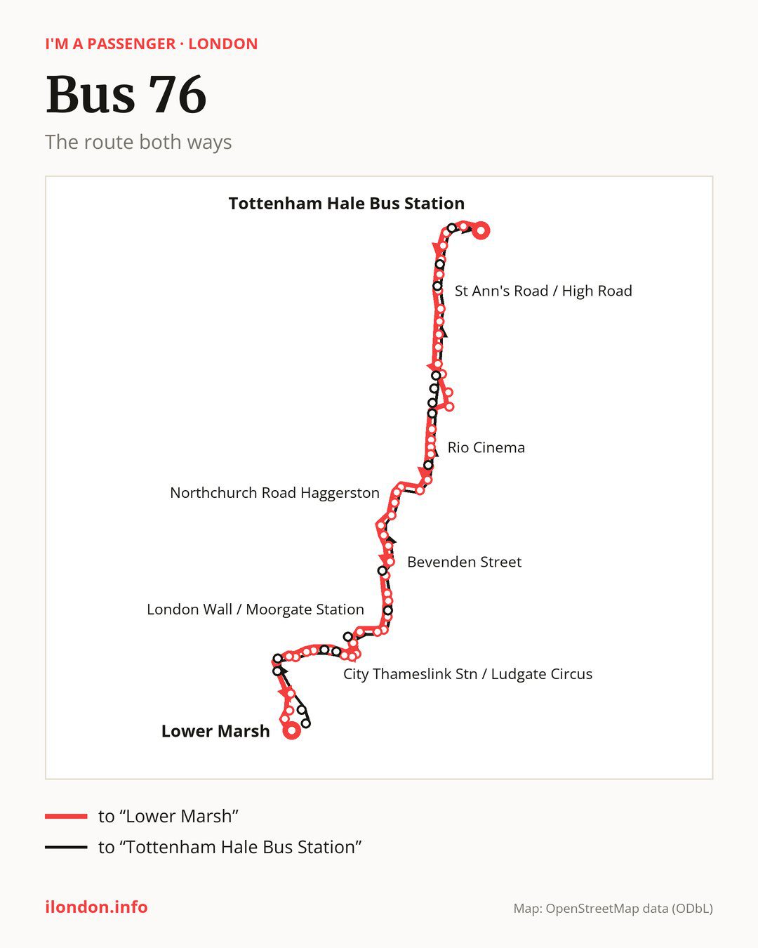
On the way back the bus takes a different route, from “Baylis Road / Lower Marsh” to “Tottenham Hale Bus Station” (50 stops). Only in this direction does it call at “Waterloo Station / Waterloo Road”, “Lancaster Place”, “Aldwych”, “Ludgate Circus”, “Ludgate Hill / Old Bailey”, “King Edward Street / St Pauls Station”, “Finsbury Square”, “Moorfields Eye Hospital”, “Kingsland High Street / Dalston Junction”, “Amhurst Road”, “Stoke Newington Police Station”, “Brooke Road”, “Stoke Newington Church St / High Street”, “Lealand Road”, “Seven Sisters Road” and “Tottenham High Road / High Cross”. Only in the direction of “Lower Marsh” does it call at, among others, “Northwold Road / Stoke Newington Common”, “Rectory Road / Brooke Road”, “Manse Road”, “Stoke Newington Rd/Amhurst Rd”, “Shacklewell Lane Dalston” and “Forest Road / Kingsland Road”. For the way back, board nearby: “Northwold Road / Stoke Newington Common” → “Stoke Newington Church St / High Street” (100 m), “Rectory Road / Brooke Road” → “Brooke Road” (300 m), “Manse Road” → “Stoke Newington Police Station” (350 m) and “Stoke Newington Rd/Amhurst Rd” → “Amhurst Road” (50 m). Towards “Lower Marsh”, board nearby: “Waterloo Station / Waterloo Road” → “Waterloo Station / York Road” (250 m), “Lancaster Place” → “Aldwych / Drury Lane” (200 m), “Aldwych” → “Aldwych / Drury Lane” (50 m) and “Ludgate Circus” → “City Thameslink Stn / Ludgate Circus” (150 m).
Left column runs down, right column runs up. Filled stops are served both ways, dashed ones only one way: 19 towards “Lower Marsh” and 17 the other way. Tap a stop to see its name.
Where to change
On part of the route, between “Tottenham Town Hall” and “Forest Road / Kingsland Road” it shares the road with routes 149 and 243; between “Egerton Road (N16)” and “Forest Road / Kingsland Road” it shares the road with route 67; between “Northchurch Road Haggerston” and “Finsbury Square / Moorgate” it shares the road with route 141.
Connections by stop, in route order:
- “Tottenham Hale Bus Station”: buses 41, 123, 192, 230 and W4
- “Park View Road (N17)”: buses 41, 123, 192, 230, 259, 279, 318, 341 and W4
- “Tottenham Town Hall”: buses 123, 230, 259, 279, 318, 341 and W4
- “College of North East London”: buses 41, 230, 259, 279, 318, 341 and W4
- “Seven Sisters Station”: buses 41, 259, 279, 318 and W4
- “South Tottenham Station”: buses 41, 259, 279 and 318
- Stops from “St Ann’s Road / High Road” to “Stamford Hill Library”: buses 253, 254, 279, 310 and 318
- “Lynmouth Road”: bus 106
- “Stoke Newington Station”: buses 73, 106, 276 and 393
- “Northwold Road / Stoke Newington Common” (only towards “Lower Marsh”): buses 73, 106, 276 and 393
- “Rectory Road / Brooke Road” (only towards “Lower Marsh”): buses 73, 106, 276 and 393
- “Manse Road” (only towards “Lower Marsh”): buses 276 and 488
- “Stoke Newington Rd/Amhurst Rd” (only towards “Lower Marsh”): bus 276
- “Princess May Road”: buses 236 and 488
- “Shacklewell Lane Dalston” (only towards “Lower Marsh”): buses 236 and 488
- “Rio Cinema”: buses 236 and 488
- “Dalston Kingsland Station”: buses 30, 38, 56, 236, 242, 277 and 488
- “Dalston Junction Station”: buses 30, 38, 56, 242, 277 and 488
- “Forest Road / Kingsland Road” (only towards “Lower Marsh”): buses 30, 38, 56, 242, 277 and 488
- “Englefield Road/ Mortimer Road”: buses 242, 277 and 488
- “Canal Walk” (only towards “Lower Marsh”): bus 21
- Stops from “Baring Street” to “Mintern Street”: buses 21 and 394
- “Bevenden Street”: buses 21, 43, 135, 205, 214 and 394
- “Old Street Stn / Moorfields Eye Hosp” (only towards “Lower Marsh”): buses 21, 43, 55, 135, 205, 214 and 394
- “City Road / Leonard Street”: buses 21, 43, 55, 135, 205 and 214
- “Epworth Street” (only towards “Lower Marsh”): buses 21, 43, 55, 153 and 214
- “Finsbury Square / Moorgate” (only towards “Lower Marsh”): buses 21, 43, 100, 153 and 214
- “Moorgate Station”: buses 21, 43, 100, 153 and 214
- “London Wall / Moorgate Station”: buses 21, 43, 100, 153 and 214
- “London Wall (West)”: buses 4, 8, 25, 56, 100 and 153
- “St. Paul’s Station” (only towards “Lower Marsh”): buses 4, 8, 17, 25, 26, 56, 100 and 133
- “New Change / Cannon Street”: buses 4, 8, 17, 25, 26, 56, 100 and 133
- “St Pauls Churchyard” (only towards “Lower Marsh”): buses 4, 8, 17, 25, 26, 56, 100 and 133
- “St Paul’s Cathedral”: buses 4, 8, 17, 25, 26, 40, 56, 63, 100 and 133
- “City Thameslink Stn / Ludgate Circus” (only towards “Lower Marsh”): buses 4, 8, 17, 25, 26, 40, 46, 56, 59, 63, 100, 133 and 341
- “Fetter Lane”: buses 17, 26, 40, 63 and 341
- “Chancery Lane (EC4)” (only towards “Lower Marsh”): buses 26 and 341
- “The Royal Courts of Justice”: buses 1, 9, 23, 26, 59, 68, 87, 91, 172, 188, 341 and SL6
- “Aldwych / Australia House” (only towards “Lower Marsh”): buses 1, 9, 23, 26, 59, 68, 87, 91, 172, 188, 341 and SL6
- “Aldwych / Drury Lane” (only towards “Lower Marsh”): buses 1, 9, 23, 26, 59, 68, 87, 91, 139, 172, 176, 188, 341 and SL6
- “Waterloo Bridge / South Bank”: buses 1, 11, 59, 68, 77, 139, 172, 176, 188, 341, 381, C10 and SL6
- “Waterloo Station / York Road” (only towards “Lower Marsh”): buses 1, 11, 59, 68, 77, 139, 172, 176, 188, 341, 381, BL1, C10 and SL6
- “County Hall” (only towards “Lower Marsh”): buses 1, 11, 12, 53, 59, 68, 77, 148, 159, 188, 381, 453, C10 and SL6
- “Lower Marsh”: buses 11, 12, 53, 59, 77, 148, 159, 381, 453 and C10
- “Baylis Road / Lower Marsh”: buses 1, 11, 12, 53, 59, 68, 77, 139, 148, 159, 172, 176, 188, 341, 453, BL1, C10 and SL6
- “Waterloo Station / Waterloo Road” (only towards “Tottenham Hale Bus Station”): buses 1, 11, 59, 68, 77, 139, 172, 176, 188, 341, 381, BL1, C10 and SL6
- “Lancaster Place” (only towards “Tottenham Hale Bus Station”): buses 1, 9, 23, 26, 59, 68, 87, 91, 139, 172, 176, 188, 341 and SL6
- “Aldwych” (only towards “Tottenham Hale Bus Station”): buses 1, 9, 23, 26, 59, 68, 87, 91, 139, 172, 176, 188, 341 and SL6
- “Ludgate Circus” (only towards “Tottenham Hale Bus Station”): buses 4, 8, 17, 25, 26, 40, 46, 59, 63, 133 and 341
- “Ludgate Hill / Old Bailey” (only towards “Tottenham Hale Bus Station”): buses 4, 8, 17, 25, 26, 40, 46, 56, 59, 63, 100, 133 and 341
- “King Edward Street / St Pauls Station” (only towards “Tottenham Hale Bus Station”): buses 4, 8, 25, 46, 56, 59, 100 and 133
- “Finsbury Square” (only towards “Tottenham Hale Bus Station”): buses 21, 43, 153 and 214
- “Moorfields Eye Hospital” (only towards “Tottenham Hale Bus Station”): buses 21, 43, 55, 135, 205, 214 and 394
- “Kingsland High Street / Dalston Junction” (only towards “Tottenham Hale Bus Station”): buses 30, 38, 56, 242, 277 and 488
- “Amhurst Road” (only towards “Tottenham Hale Bus Station”): bus 276
- Stops from “Stoke Newington Police Station” to “Stoke Newington Church St / High Street” (only towards “Tottenham Hale Bus Station”): buses 73, 106, 276 and 393
- “Lealand Road” (only towards “Tottenham Hale Bus Station”): buses 279 and 318
- “Seven Sisters Road” (only towards “Tottenham Hale Bus Station”): buses 41, 259, 279, 318 and W4
- “Tottenham High Road / High Cross” (only towards “Tottenham Hale Bus Station”): buses 123, 230, 259, 279, 318, 341 and W4
Pages for these routes: bus BL1, bus C10, bus SL6, bus W4, bus 1, bus 4, bus 8, bus 9, bus 11, bus 12, bus 17, bus 21, bus 23, bus 25, bus 26, bus 30, bus 38, bus 40, bus 41, bus 43, bus 46, bus 53, bus 55, bus 56, bus 63.
Passes and concessions
Our page “How to pay for public transport in London” describes tickets, passes and concessions, including any differences between modes of transport.
Questions about bus 76
Where does bus 76 start its return journey?
At “Baylis Road / Lower Marsh” (300 m from “Lower Marsh”).
Where can I change from bus 76 to another bus route?
Most routes stop at “Aldwych / Drury Lane” (only towards “Lower Marsh”; 1, 9, 23, 26, 59, 68, 87, 91, 139, 172, 176, 188, 341 and SL6) and “Baylis Road / Lower Marsh” (1, 11, 12, 53, 59, 68, 77, 139, 148, 159, 172, 176, 188, 341, 453, BL1, C10 and SL6). All other stops with connections are listed above.
Checked on 27 September 2026. Source of the route and stops: Transport for London (TfL).