
Bus route 135 in London runs between “Crossharbour Asda” and “Moorfields Eye Hospital”. The return journey starts at “Old Street Station” (350 m from “Moorfields Eye Hospital”) and ends at “Isle of Dogs Asda” (50 m from “Crossharbour Asda”).
The route of bus 135
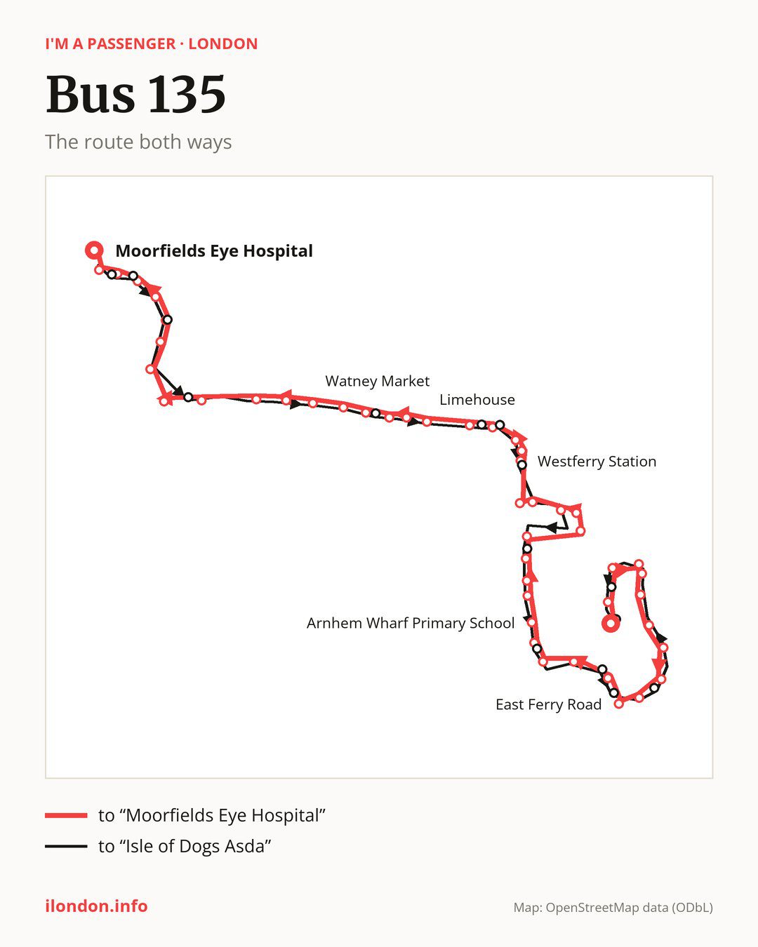
Towards “Moorfields Eye Hospital”: 47 stops. After “Crossharbour Asda”, the bus calls at “Crossharbour”, “Harbour Exchange Square”, “Jack Dash House”, “Stewart Street”, “St John’s Park”, “Cubitt Town School”, “Pier Street”, “Christ Church Isle of Dogs”, “Island Gardens”, “East Ferry Road”. Then “Mudchute Station / Spindrift Ave”, “Telegraph Place”, “St Edmund’s School”, “Crews Street”, “Arnhem Wharf Primary School”, “Sir John McDougall Gardens”, “Barkantine Clinic / Hutchings St”, “Byng Street”, “Marsh Wall / Heron Quay”, “Canary Wharf Station”. Then “Canada Square South / Canary Wharf Station”, “Canary Wharf Underground Station”, “West India Avenue”, “Westferry Circus / Canary Wharf Pier”, “Westferry Station”, “Salter Street”, “Limehouse Police Station”, “Limehouse Town Hall”, “Lowell Street”, “Limehouse”. Then “Stepney Methodist Church”, “Marion Richardson School”, “Exmouth Estate”, “St Mary’s & St Michael’s Church”, “Watney Market”, “New Road (E1)”, “Henriques Street”, “Aldgate East”, “Duke’s Place”, “Liverpool Street Station”. Before “Moorfields Eye Hospital”: “Primrose Street”, “Shoreditch High Street Station”, “Curtain Road”, “Ravey Street”, “Old Street Station”.
On the way back the bus takes a different route, from “Old Street Station” to “Isle of Dogs Asda” (46 stops). Only in this direction does it call at “Shoreditch Fire Station”, “Pitfield Street Shoreditch”, “Commercial Street / Worship St”, “St Botolph Street”, “Arbour Square”, “Salmon Lane”, “Burdett Road”, “Westferry”, “Cuba Street”, “Crews Street / The Space Theatre”, “Mudchute”, “Millwall Park”, “George Green’s School” and “East Ferry Road Crossharbour”. Only in the direction of “Moorfields Eye Hospital” does it call at, among others, “East Ferry Road”, “Mudchute Station / Spindrift Ave”, “Crews Street”, “Byng Street”, “Canada Square South / Canary Wharf Station” and “Westferry Circus / Canary Wharf Pier”. For the way back, board nearby: “East Ferry Road” → “Millwall Park” (100 m), “Mudchute Station / Spindrift Ave” → “Mudchute” (100 m), “Crews Street” → “Crews Street / The Space Theatre” (50 m) and “Byng Street” → “Cuba Street” (100 m). Towards “Moorfields Eye Hospital”, board nearby: “Shoreditch Fire Station” → “Old Street Station” (50 m), “Pitfield Street Shoreditch” → “Ravey Street” (50 m), “Commercial Street / Worship St” → “Shoreditch High Street Station” (50 m) and “St Botolph Street” → “Aldgate East” (150 m).
Left column runs down, right column runs up. Filled stops are served both ways, dashed ones only one way: 16 towards “Moorfields Eye Hospital” and 15 the other way. Tap a stop to see its name.
Connections
On part of the route, between “St Edmund’s School” and “Salter Street” it shares the road with routes 277 and D7; between “Limehouse Town Hall” and “Aldgate East” it shares the road with routes 15 and 115; between “Canada Square South / Canary Wharf Station” and “Limehouse” it shares the road with route D3.
Connections by stop, in route order:
- Stops from “Crossharbour Asda” to “Cubitt Town School”: buses D6 and D8
- “Byng Street” (only towards “Moorfields Eye Hospital”): bus D8
- “Marsh Wall / Heron Quay”: buses D8 and SL4
- “Canary Wharf Station”: buses D8 and SL4
- “Canada Square South / Canary Wharf Station” (only towards “Moorfields Eye Hospital”): buses D8 and SL4
- “Canary Wharf Underground Station”: buses D8 and SL4
- “West India Avenue”: buses D8 and SL4
- “Westferry Circus / Canary Wharf Pier” (only towards “Moorfields Eye Hospital”): buses D8 and SL4
- “Westferry Station” (only towards “Moorfields Eye Hospital”): bus D6
- “Salter Street” (only towards “Moorfields Eye Hospital”): bus D6
- “Limehouse Police Station”: bus D6
- “Limehouse Town Hall” (only towards “Moorfields Eye Hospital”): bus D6
- “Exmouth Estate” (only towards “Moorfields Eye Hospital”): bus 339
- “St Mary’s & St Michael’s Church”: bus 339
- “Watney Market”: bus 339
- “Henriques Street”: buses 25 and 254
- “Aldgate East”: buses 25, 42, 78, 100, 242 and 254
- “Duke’s Place” (only towards “Moorfields Eye Hospital”): buses 8, 21, 25, 26, 35, 42, 43, 47, 78, 100, 141, 149, 242, 254, 344 and 388
- “Liverpool Street Station”: buses 8, 21, 26, 35, 42, 43, 47, 78, 100, 141, 149, 153, 344 and 388
- “Primrose Street”: buses 8, 26, 35, 42, 47, 78, 149, 153, 242, 344 and 388
- “Shoreditch High Street Station”: buses 8, 26, 35, 42, 47, 55, 78, 149, 242, 243 and 388
- “Curtain Road” (only towards “Moorfields Eye Hospital”): buses 8, 26, 35, 42, 47, 55, 78, 149, 242, 243 and 388
- “Ravey Street” (only towards “Moorfields Eye Hospital”): buses 26, 35, 47, 55, 78, 149, 242 and 243
- “Old Street Station”: buses 21, 43, 55, 76, 141, 214, 243 and 394
- “Moorfields Eye Hospital”: buses 21, 43, 55, 76, 141, 214, 243 and 394
- “Shoreditch Fire Station” (only towards “Isle of Dogs Asda”): buses 21, 43, 55, 76, 141, 214 and 243
- “Pitfield Street Shoreditch” (only towards “Isle of Dogs Asda”): buses 35, 43, 47, 55, 78, 214 and 243
- “Commercial Street / Worship St” (only towards “Isle of Dogs Asda”): buses 8, 26, 35, 42, 47, 78, 149, 242 and 388
- “St Botolph Street” (only towards “Isle of Dogs Asda”): buses 25, 42, 78, 100, 242 and 254
- Stops from “Salmon Lane” to “Westferry” (only towards “Isle of Dogs Asda”): bus D6
- “Cuba Street” (only towards “Isle of Dogs Asda”): bus D8
- “East Ferry Road Crossharbour” (only towards “Isle of Dogs Asda”): buses D6 and D8
- “Isle of Dogs Asda”: buses D6 and D8
Pages for these routes: bus D3, bus D6, bus D7, bus D8, bus SL4, bus 8, bus 15, bus 21, bus 25, bus 26, bus 35, bus 42, bus 43, bus 47, bus 55, bus 76, bus 78, bus 100, bus 115, bus 153.
Passes and concessions
Tickets, passes and concessions are covered on a separate page: how to pay for public transport in London.
Questions and answers
Where does bus 135 start its return journey?
At “Old Street Station” (350 m from “Moorfields Eye Hospital”).
Where can I change from bus 135 to another bus route?
Most routes stop at “Duke’s Place” (only towards “Moorfields Eye Hospital”; 8, 21, 25, 26, 35, 42, 43, 47, 78, 100, 141, 149, 242, 254, 344 and 388) and “Liverpool Street Station” (8, 21, 26, 35, 42, 43, 47, 78, 100, 141, 149, 153, 344 and 388). All other stops with connections are listed above.
Checked on 26 September 2026. Source of the route and stops: Transport for London (TfL).