

Bus route S4 in London links “Waddon Marsh Sainsburys” and “Sutton / Marshalls Road”.
The route of bus S4
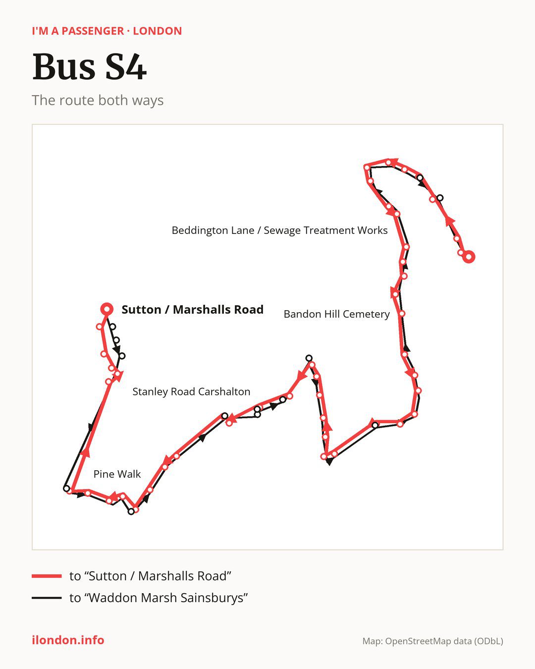
Towards “Sutton / Marshalls Road”: 47 stops. After “Waddon Marsh Sainsburys”, the bus calls at “Commerce Way”, “Purley Way/Beddington Farm Rd”, “Ampere Way Tram Stop / Valley Park”, “Therapia Lane Tram Stop”, “Therapia Lane Tram Stop / Coomber Way”, “Therapia Lane Tram Depot”, “Prologis Business Park Beddington”, “Therapia Lane”, “Beddington Cross”, “Beddington Lane / Sewage Treatment Works”. Then “Beddington Asda”, “Beddington Village”, “Richmond Road Beddington”, “Hilliers Lane”, “Bandon Hill Cemetery”, “Mellows Park / Plough Lane”, “Wilson’s School”, “St Elphege’s School”, “Spitfire Road”, “Roundshaw Phoenix Centre”. Then “The Newlands”, “Sandy Lane South / Woodcote Green”, “Woodcote Green”, “Hall Road (SM6)”, “Blenheim Gardens (SM6)”, “Woodcote Road / Stafford Road”, “Wallington Town Centre”, “Wallington Station”, “Gaynesford Road”, “Stanley Road Carshalton”. Then “Queen Mary’s Ave/Gaynesford Rd”, “Crichton Road”, “The Warren”, “West Way”, “Pine Walk”, “Banstead Road South / Downs Rd”, “Royal Marsden Hospital”, “Royal Marsden Hospital / Downs Road”, “Belmont”, “Belmont / Station Road”. Before “Sutton / Marshalls Road”: “Worcester Road / Mulgrave Road”, “Sutton Station”, “Sutton / Grove Road”, “Sutton Civic Centre”, “St. Nicholas Centre”.
On the way back the bus takes a different route, from “Sutton / Marshalls Road” to “Waddon Marsh Sainsburys” (44 stops). Only in this direction does it call at “Manor Place”, “Times Square”, “Sutton Police Station”, “Avenue Road / Station Road”, “Downs Road / Banstead Road Sth”, “Stanley Park Road”, “Stanley Road / North Avenue”, “Stanley Road / Stanley Park Road”, “Boundary Road (SM5)”, “Grosvenor Road / Wallington”, “Foresters Drive / The Newlands”, “Beddington Farm Road” and “Ampere Way Tram / Valley Park”. Only in the direction of “Sutton / Marshalls Road” does it call at, among others, “Commerce Way”, “Ampere Way Tram Stop / Valley Park”, “Therapia Lane Tram Stop / Coomber Way”, “Richmond Road Beddington”, “The Newlands” and “Sandy Lane South / Woodcote Green”. For the way back, board nearby: “Commerce Way” → “Waddon Marsh Sainsburys” (150 m), “Ampere Way Tram Stop / Valley Park” → “Ampere Way Tram / Valley Park” (100 m), “Therapia Lane Tram Stop / Coomber Way” → “Therapia Lane Tram Stop” (250 m) and “Richmond Road Beddington” → “Beddington Village” (200 m). Towards “Sutton / Marshalls Road”, board nearby: “Manor Place” → “St. Nicholas Centre” (200 m), “Times Square” → “Sutton Civic Centre” (250 m), “Sutton Police Station” → “Sutton / Grove Road” (250 m) and “Avenue Road / Station Road” → “Belmont / Station Road” (50 m).
Left column runs down, right column runs up. Filled stops are served both ways, dashed ones only one way: 16 towards “Sutton / Marshalls Road” and 13 the other way. Tap a stop to see its name.
Where to change
On part of the route, between “West Way” and “Belmont” it shares the road with route S3; between “Woodcote Green” and “Wallington Station” it shares the road with routes 127 and 463; between “Sutton Station” and “Sutton / Marshalls Road” it shares the road with route S2.
Connections by stop, in route order:
- “Waddon Marsh Sainsburys”: tram Tram; buses 289 and 439
- “Commerce Way” (only towards “Sutton / Marshalls Road”): tram Tram; buses 289 and 439
- “Purley Way/Beddington Farm Rd”: tram Tram; buses 289 and 439
- “Ampere Way Tram Stop / Valley Park” (only towards “Sutton / Marshalls Road”): tram Tram; bus 289
- “Therapia Lane Tram Stop”: tram Tram; bus 264
- “Therapia Lane Tram Stop / Coomber Way” (only towards “Sutton / Marshalls Road”): tram Tram; bus 264
- “Hilliers Lane”: buses 407 and 410
- “Bandon Hill Cemetery”: buses 407 and 410
- “Mellows Park / Plough Lane”: bus 157
- “Wilson’s School”: bus 157
- Stops from “Woodcote Road / Stafford Road” to “Wallington Station”: buses 151, 157 and 410
- “Gaynesford Road” (only towards “Sutton / Marshalls Road”): buses 151 and 410
- “Royal Marsden Hospital”: buses 420 and S1
- “Royal Marsden Hospital / Downs Road”: buses 280, 420 and S1
- “Belmont”: buses 280, 420 and S1
- “Belmont / Station Road”: bus 280
- “Worcester Road / Mulgrave Road” (only towards “Sutton / Marshalls Road”): buses 151, 164, 213, 280, 407, 413, 420, 470, S1 and SL7
- “Sutton Station”: buses 151, 164, 213, 280, 407, 413, 420, 470, S1 and SL7
- “Sutton / Grove Road” (only towards “Sutton / Marshalls Road”): buses 151, 164, 213, 280, 407, 413, 420, 470, S1 and SL7
- “Sutton Civic Centre” (only towards “Sutton / Marshalls Road”): buses 151, 164, 213, 280, 407, 413, 420, 470, S1 and SL7
- “St. Nicholas Centre” (only towards “Sutton / Marshalls Road”): buses 151, 164, 213, 280, 407, 413, 420, 470 and S1
- “Sutton / Marshalls Road”: buses 151, 164, 213, 280, 407, 413, 420, 470 and S1
- “Manor Place” (only towards “Waddon Marsh Sainsburys”): buses 151, 164, 213, 280, 407, 413, 420, 470 and S1
- “Times Square” (only towards “Waddon Marsh Sainsburys”): buses 151, 164, 213, 280, 407, 413, 420, 470, S1 and SL7
- “Sutton Police Station” (only towards “Waddon Marsh Sainsburys”): buses 151, 164, 213, 280, 407, 413, 420, 470, S1 and SL7
- “Avenue Road / Station Road” (only towards “Waddon Marsh Sainsburys”): bus 280
- “Grosvenor Road / Wallington” (only towards “Waddon Marsh Sainsburys”): buses 151, 157 and 410
- “Beddington Farm Road” (only towards “Waddon Marsh Sainsburys”): tram Tram; bus 264
- “Ampere Way Tram / Valley Park” (only towards “Waddon Marsh Sainsburys”): tram Tram; bus 289
Pages for these routes: tram Tram, bus S1, bus S2, bus S3, bus SL7.
Passes and concessions
Which passes are available and who travels free is explained on a separate page: how to pay for public transport in London.
Questions about bus S4
Does bus S4 go to “Prologis Business Park Beddington”?
Yes, in both directions.
Where can I change from bus S4 to another bus route?
Most routes stop at “Worcester Road / Mulgrave Road” (only towards “Sutton / Marshalls Road”; 151, 164, 213, 280, 407, 413, 420, 470, S1 and SL7) and “Sutton Station” (151, 164, 213, 280, 407, 413, 420, 470, S1 and SL7). All other stops with connections are listed above.
Checked on 24 September 2026. Source of the route and stops: Transport for London (TfL).