
Bus route N25 in London links “Hainault Street” and “Great Titchfield Street / Oxford Circus Station”. This is a night route. The return journey starts at “Holles Street” (350 m from “Great Titchfield Street / Oxford Circus Station”).
Where bus N25 goes
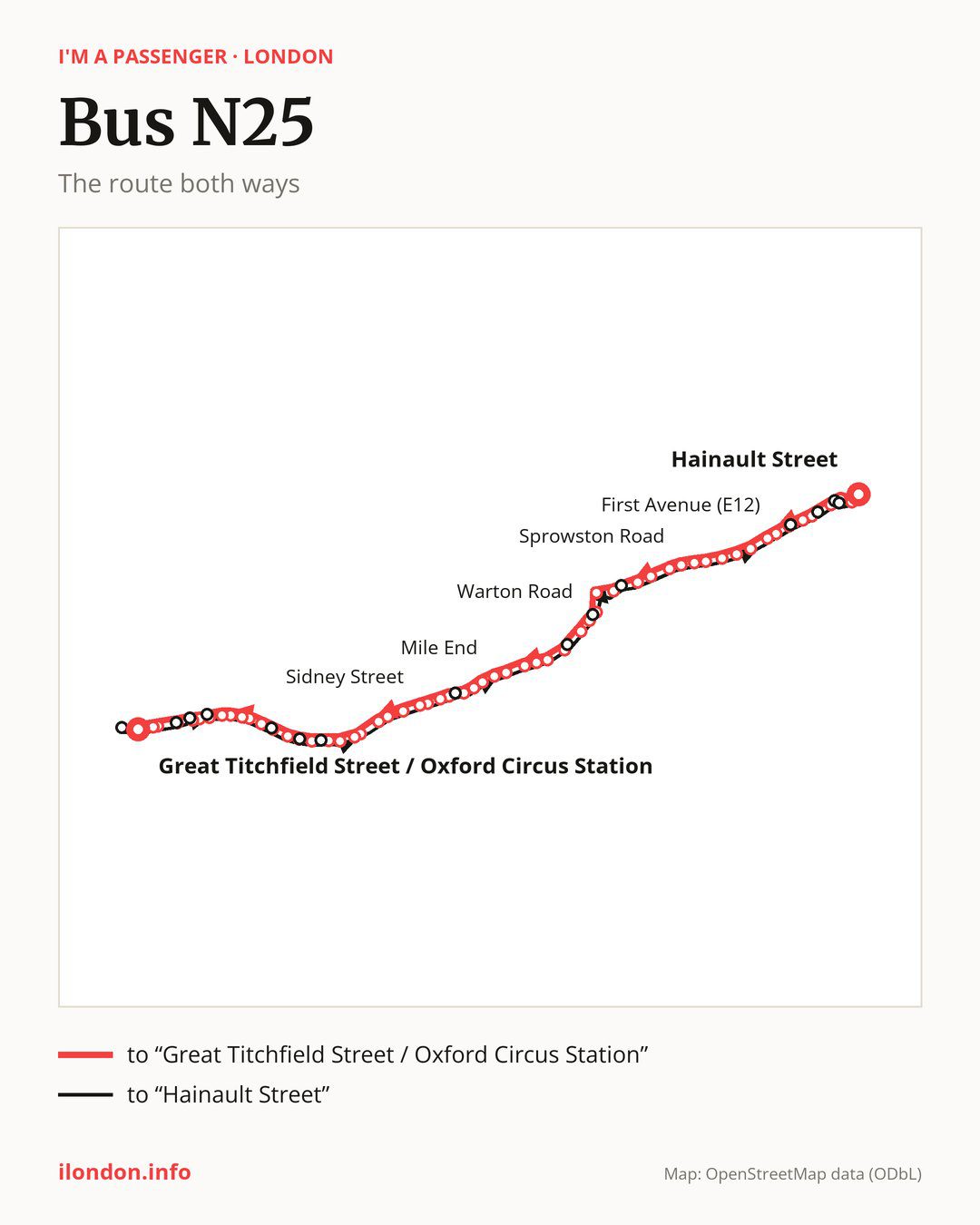
From “Hainault Street” to “Great Titchfield Street / Oxford Circus Station”: 58 stops. On the way: “Redbridge Central Library”, “Ilford Broadway”, “Chapel Road”, “Dersingham Avenue”, “Little Ilford Lane”, “Rabbits Road”, “First Avenue (E12)”, “High Street North Manor Park”, “Woodgrange Park Station”, “Shrewsbury Road Romford”. Then “Katherine Road Forest Gate”, “Green Street (E7)”, “Woodgrange Road”, “Sprowston Road”, “Margery Park Road”, “Atherton Leisure Centre”, “Water Lane / University Of East London”, “Stratford Centre / Moorfields Eye Hospital”, “Stratford Bus Station”, “Stratford High Street / Carpenters Road”. Then “Warton Road”, “Abbey Lane”, “Bow Flyover”, “Bow Church”, “Bow Church Station”, “Bow Road Station”, “Coborn Road”, “Mile End”, “Regents Canal”, “Queen Mary / University Of London”. Then “Ocean Estate”, “Stepney Green Station”, “Stepney Green”, “Booth Memorial”, “Sidney Street”, “Whitechapel Station / Royal London Hospital”, “The East London Mosque”, “Altab Ali Park”, “Aldgate East”, “Aldgate”. Then “St Katharine Cree”, “St Mary Axe”, “Bank Station / Cornhill”, “Poultry / Bank Station”, “Bread Street”, “St. Paul’s Station”, “City Thameslink”, “Holborn Circus”, “Holborn Circus / Fetter Lane”, “Chancery Lane”. Before “Great Titchfield Street / Oxford Circus Station”: “Brownlow Street”, “Holborn Station”, “High Holborn”, “New Oxford Street / High Holborn”, “Tottenham Court Road Station”, “Wardour Street”.
On the way back the bus takes a different route, from “Holles Street” to “Hainault Street” (57 stops). Only in this direction does it call at “New Oxford Street”, “Museum Street”, “Procter Street”, “King Edward Street”, “Bank Station / Poultry”, “Bishopsgate City of London”, “Bancroft Road / Ocean Estate”, “Marshgate Lane”, “Stratford H St/Carpenters Road”, “Litchfield Avenue”, “Seventh Avenue”, “North Circular Road Ilford”, “Ilford Station / Ilford Hill” and “Ilford / Chapel Road”. Only in the direction of “Great Titchfield Street / Oxford Circus Station” does it call at, among others, “Ilford Broadway”, “Chapel Road”, “Dersingham Avenue”, “Little Ilford Lane”, “Sprowston Road” and “Stratford High Street / Carpenters Road”. For the way back, board nearby: “Ilford Broadway” → “Ilford / Chapel Road” (100 m), “Chapel Road” → “Ilford Station / Ilford Hill” (100 m), “Dersingham Avenue” → “North Circular Road Ilford” (150 m) and “Little Ilford Lane” → “Seventh Avenue” (250 m). Towards “Great Titchfield Street / Oxford Circus Station”, board nearby: “New Oxford Street” → “Tottenham Court Road Station” (50 m), “Museum Street” → “New Oxford Street / High Holborn” (50 m), “Procter Street” → “Holborn Station” (100 m) and “King Edward Street” → “St. Paul’s Station” (50 m).
Left column runs down, right column runs up. Filled stops are served both ways, dashed ones only one way: 16 towards “Great Titchfield Street / Oxford Circus Station” and 15 the other way. Tap a stop to see its name.
Other routes along the way
Shared sections with other routes: between “Hainault Street” and “Stratford Bus Station” it shares the road with route N86; between “Warton Road” and “Aldgate East” it shares the road with route N205; between “Bank Station / Cornhill” and “Tottenham Court Road Station” it shares the road with route N8.
Connections by stop, in route order:
- Stops from “Mile End” to “Queen Mary / University Of London”: bus N277
- “Stepney Green”: bus N253
- “Booth Memorial”: bus N253
- “Sidney Street” (only towards “Great Titchfield Street / Oxford Circus Station”): bus N253
- “Whitechapel Station / Royal London Hospital”: bus N253
- “The East London Mosque”: buses N15 and N253
- “Altab Ali Park”: buses N15 and N253
- “Aldgate East”: buses N15, N253 and N551
- “Aldgate”: buses N15, N253 and N551
- “St Katharine Cree”: buses N15, N26, N133, N253 and N551
- “St Mary Axe”: buses N15, N26, N133 and N551
- “Bank Station / Cornhill”: buses N15, N21, N26, N133, N199 and N551
- “Poultry / Bank Station” (only towards “Great Titchfield Street / Oxford Circus Station”): buses N15, N21, N26, N199 and N551
- “Bread Street” (only towards “Great Titchfield Street / Oxford Circus Station”): buses N15, N21, N26, N199 and N551
- “St. Paul’s Station”: buses N15, N21, N26, N63, N199 and N551
- “City Thameslink”: buses N15, N21, N26, N63, N89, N199 and N551
- “Holborn Circus”: bus N63
- “Holborn Circus / Fetter Lane”: bus N63
- “Chancery Lane”: buses N19, N41 and N55
- “Brownlow Street”: buses N19, N38, N41 and N55
- “Holborn Station” (only towards “Great Titchfield Street / Oxford Circus Station”): buses N1, N19, N38, N41, N55, N68, N91, N171 and N207
- “High Holborn” (only towards “Great Titchfield Street / Oxford Circus Station”): buses N1, N19, N38, N41, N55, N68, N91, N171 and N207
- “New Oxford Street / High Holborn” (only towards “Great Titchfield Street / Oxford Circus Station”): buses N1, N19, N38, N41, N55, N68, N91, N171, N207 and N253
- “Tottenham Court Road Station”: buses N1, N5, N19, N20, N29, N38, N41, N55, N68, N73, N171, N207, N253 and N279
- “Wardour Street” (only towards “Great Titchfield Street / Oxford Circus Station”): buses N5, N20, N29, N55, N73, N207, N253 and N279
- “Great Titchfield Street / Oxford Circus Station”: buses N3, N7, N15, N18, N22, N55, N73, N109, N113, N118, N136, N137 and N207
- “Holles Street”: buses N3, N7, N15, N18, N22, N55, N73, N109, N113, N118, N136, N137 and N207
- “New Oxford Street” (only towards “Hainault Street”): buses N1, N5, N19, N20, N29, N38, N41, N55, N68, N73, N171, N207, N253 and N279
- “Museum Street” (only towards “Hainault Street”): buses N1, N19, N38, N41, N55, N68, N91, N171, N207 and N253
- “Procter Street” (only towards “Hainault Street”): buses N1, N19, N38, N41, N55, N68, N91, N171 and N207
- “King Edward Street” (only towards “Hainault Street”): buses N15, N21, N26, N63, N199 and N551
- “Bank Station / Poultry” (only towards “Hainault Street”): buses N15, N21, N26, N199 and N551
- “Bishopsgate City of London” (only towards “Hainault Street”): buses N15, N21, N26, N133 and N551
Pages for these routes: bus N1, bus N109, bus N113, bus N118, bus N133, bus N136, bus N137, bus N15, bus N171, bus N18, bus N19, bus N199, bus N20, bus N205, bus N207, bus N21, bus N22, bus N253, bus N26, bus N279.
Passes and concessions
Tickets, passes and concessions are covered on a separate page: how to pay for public transport in London.
Questions about bus N25
Where does bus N25 start its return journey?
At “Holles Street” (350 m from “Great Titchfield Street / Oxford Circus Station”).
Where can I change from bus N25 to another bus route?
Most routes stop at “Tottenham Court Road Station” (N1, N5, N19, N20, N29, N38, N41, N55, N68, N73, N171, N207, N253 and N279) and “New Oxford Street” (only towards “Hainault Street”; N1, N5, N19, N20, N29, N38, N41, N55, N68, N73, N171, N207, N253 and N279). All other stops with connections are listed above.
Checked on 7 October 2026. Source of the route and stops: Transport for London (TfL).