
Bus route D7 in London links “Poplar / All Saints Church” and “Mile End”. The return journey starts at “Mile End Station / Bow Road” (250 m from “Mile End”).
Where bus D7 goes
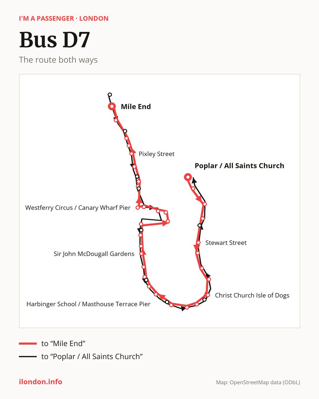
Towards “Mile End”: 33 stops. After “Poplar / All Saints Church”, the bus calls at “Poplar High Street / Blackwall”, “Aspen Way”, “Coldharbour”, “Stewart Street”, “St John’s Park”, “Cubitt Town School”, “Pier Street”, “Christ Church Isle of Dogs”, “Island Gardens”, “East Ferry Road”. Then “Langbourne Place”, “Harbinger School / Masthouse Terrace Pier”, “St Edmund’s School”, “Crews Street”, “Arnhem Wharf Primary School”, “Sir John McDougall Gardens”, “Barkantine Clinic / Hutchings St”, “Byng Street”, “Marsh Wall / Heron Quay”, “Canary Wharf Station”. Then “Canada Square South / Canary Wharf Station”, “Canary Wharf Underground Station”, “West India Avenue”, “Westferry Circus / Canary Wharf Pier”, “Westferry Station”, “Salter Street”, “East India Dock Road / Limehouse”, “Pixley Street”, “St Paul’s Way”, “Ackroyd Drive / Burdett Road”. Before “Mile End”: “Eric Street”.
On the way back the bus takes a different route, from “Mile End Station / Bow Road” to “Poplar / All Saints Church” (34 stops). Only in this direction does it call at “Mile End Park Leisure Centre”, “Limehouse Police Station”, “Westferry”, “Cuba Street”, “Crews Street / The Space Theatre”, “Maconochies Road”, “George Green’s School” and “The Blue Bridge”. Only in the direction of “Mile End” does it call at, among others, “Langbourne Place”, “Crews Street”, “Byng Street”, “Canada Square South / Canary Wharf Station”, “Westferry Circus / Canary Wharf Pier” and “Westferry Station”. For the way back, board nearby: “Langbourne Place” → “Maconochies Road” (100 m), “Crews Street” → “Crews Street / The Space Theatre” (50 m), “Byng Street” → “Cuba Street” (100 m) and “Canada Square South / Canary Wharf Station” → “Canary Wharf Underground Station” (150 m). Towards “Mile End”, board nearby: “Mile End Park Leisure Centre” → “Ackroyd Drive / Burdett Road” (150 m), “Limehouse Police Station” → “Salter Street” (100 m), “Westferry” → “Westferry Station” (50 m) and “Cuba Street” → “Byng Street” (100 m).
Left column runs down, right column runs up. Filled stops are served both ways, dashed ones only one way: 8 towards “Mile End” and 9 the other way. Tap a stop to see its name.
Other routes along the way
On part of the route, between “Langbourne Place” and “Mile End” it shares the road with route 277; between “St Edmund’s School” and “Salter Street” it shares the road with route 135; between “Canada Square South / Canary Wharf Station” and “Salter Street” it shares the road with route D3.
Connections by stop, in route order:
- “Poplar / All Saints Church”: buses 15, 108, 115, 309 and D8
- “Poplar High Street / Blackwall”: buses 15, 108, 115, D8 and SL4
- “Aspen Way”: buses 15, D8 and SL4
- Stops from “Stewart Street” to “Cubitt Town School”: bus D8
- “Byng Street” (only towards “Mile End”): bus D8
- “Marsh Wall / Heron Quay”: buses D8 and SL4
- “Canary Wharf Station”: buses D8 and SL4
- “Canada Square South / Canary Wharf Station” (only towards “Mile End”): buses D8 and SL4
- “Canary Wharf Underground Station”: buses D8 and SL4
- “West India Avenue”: buses D8 and SL4
- “Westferry Circus / Canary Wharf Pier” (only towards “Mile End”): buses D8 and SL4
- “Westferry Station” (only towards “Mile End”): buses 15 and 115
- “Salter Street” (only towards “Mile End”): buses 15 and 115
- “East India Dock Road / Limehouse”: buses 15 and 115
- “Pixley Street”: buses 15, 115 and 309
- “St Paul’s Way”: bus 309
- “Ackroyd Drive / Burdett Road” (only towards “Mile End”): bus 309
- “Eric Street”: buses 309 and 323
- “Mile End”: buses 25, 205, 323, 339 and 425
- “Mile End Station / Bow Road”: buses 25, 205, 323, 339 and 425
- “Mile End Park Leisure Centre” (only towards “Poplar / All Saints Church”): buses 309 and 323
- “Limehouse Police Station” (only towards “Poplar / All Saints Church”): buses 15 and 115
- “Westferry” (only towards “Poplar / All Saints Church”): buses 15 and 115
- “Cuba Street” (only towards “Poplar / All Saints Church”): bus D8
Passes and concessions
Which passes are available and who travels free is explained on a separate page: how to pay for public transport in London.
Questions and answers
Where does bus D7 start its return journey?
At “Mile End Station / Bow Road” (250 m from “Mile End”).
Where can I change from bus D7 to another bus route?
Most routes stop at “Poplar / All Saints Church” (15, 108, 115, 309 and D8) and “Poplar High Street / Blackwall” (15, 108, 115, D8 and SL4). All other stops with connections are listed above.
Checked on 7 October 2026. Source of the route and stops: Transport for London (TfL).