

Bus route U1 in London runs between “Ruislip” and “West Drayton Station”.
The route of bus U1
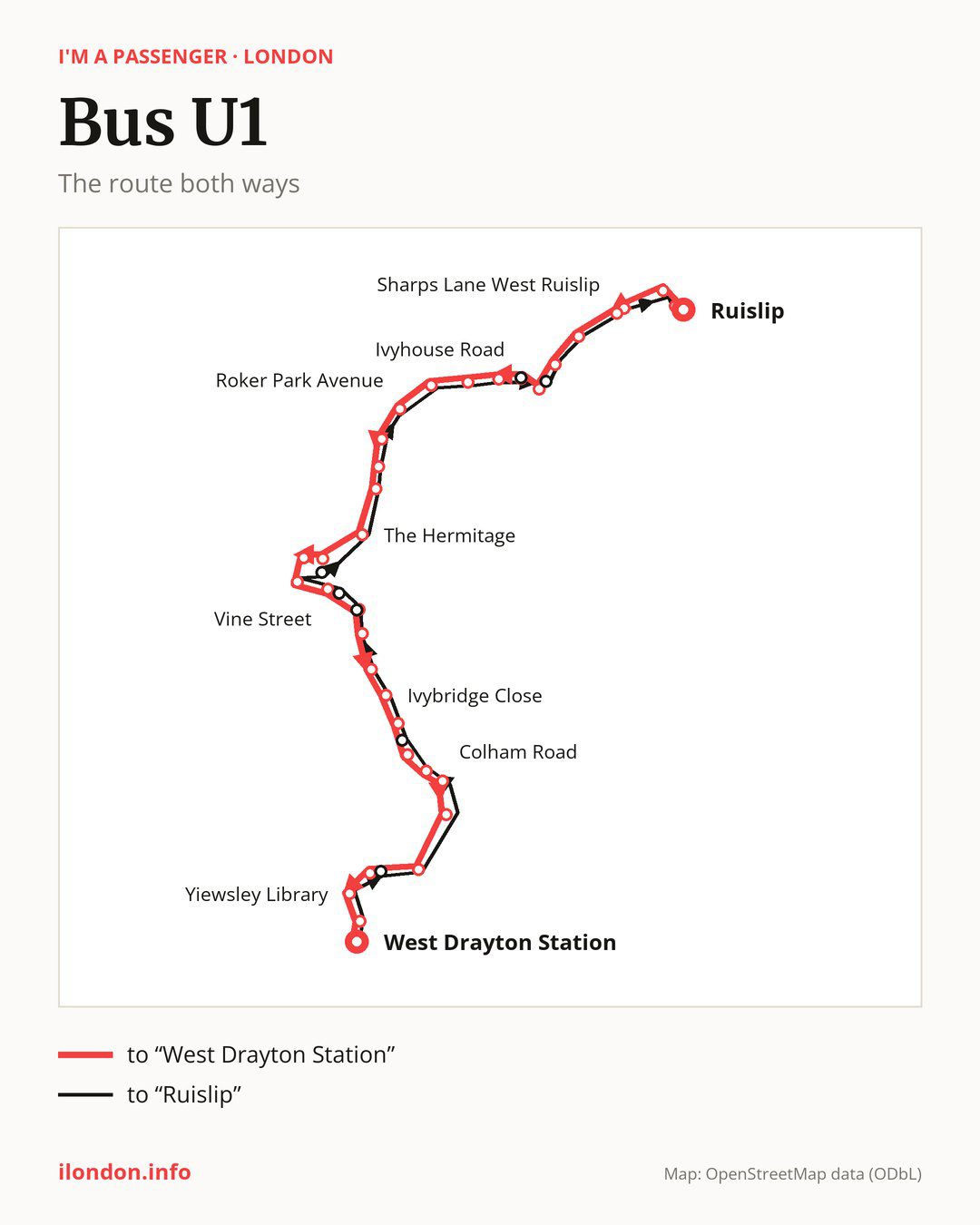
From “Ruislip” to “West Drayton Station”: 35 stops. On the way: “Brickwall Lane”, “Midcroft”, “Church Avenue”, “Sharps Lane West Ruislip”, “West Ruislip”, “Oak Avenue”, “Ickenham Pump”, “Ivyhouse Road”, “Wallasey Crescent”, “Thornhill Road”. Then “Breakspear Road South”, “Roker Park Avenue”, “Warren Road Ickenham”, “Harefield Road”, “North Common Road (UB8)”, “The Hermitage”, “Belmont Road”, “Uxbridge High Street”, “Crown Walk”, “Vine Street”. Then “St Andrew’s Church / Hillingdon Road”, “Manor Waye / St Andrew’s Park”, “The Greenway”, “Ivybridge Close”, “Brunel University”, “Brunel University Sports Park”, “Hillingdon Hospital”, “Colham Road”, “Violet Avenue”, “Apple Tree Avenue”. Before “West Drayton Station”: “Otterfield Road”, “Yiewsley Library”, “Yiewsley High Street”.
On the way back the bus takes a different route, from “West Drayton Station” to “Ruislip” (33 stops). Only in this direction does it call at “Milburn Drive”, “Kingston La Pentecostal Church”, “St Andrew’s Church (UB8)”, “Civic Centre”, “Uxbridge Station”, “Rectory Way” and “Austins Lane”. Only in the direction of “West Drayton Station” does it call at, among others, “Ickenham Pump”, “Ivyhouse Road”, “Belmont Road”, “Uxbridge High Street”, “Vine Street” and “St Andrew’s Church / Hillingdon Road”. For the way back, board nearby: “Ickenham Pump” → “Austins Lane” (100 m), “Ivyhouse Road” → “Rectory Way” (50 m), “Belmont Road” → “Uxbridge Station” (150 m) and “Uxbridge High Street” → “Uxbridge Station” (250 m). Towards “West Drayton Station”, board nearby: “Milburn Drive” → “Otterfield Road” (100 m), “Kingston La Pentecostal Church” → “Brunel University Sports Park” (150 m), “St Andrew’s Church (UB8)” → “St Andrew’s Church / Hillingdon Road” (50 m) and “Civic Centre” → “Vine Street” (150 m).
Left column runs down, right column runs up. Filled stops are served both ways, dashed ones only one way: 9 towards “West Drayton Station” and 7 the other way. Tap a stop to see its name.
Other routes along the way
Shared sections with other routes: between “Uxbridge High Street” and “Colham Road” it shares the road with routes U4 and U7; between “Hillingdon Hospital” and “West Drayton Station” it shares the road with route U3; between “Brickwall Lane” and “Oak Avenue” it shares the road with route 278.
Connections by stop, in route order:
- Stops from “Ruislip” to “Midcroft”: buses 114, 331, 398, E7, H13 and U10
- Stops from “Church Avenue” to “Oak Avenue”: bus U10
- “Ickenham Pump” (only towards “West Drayton Station”): bus U10
- “Ivyhouse Road” (only towards “West Drayton Station”): bus U10
- Stops from “Roker Park Avenue” to “North Common Road (UB8)”: buses U9 and U10
- “The Hermitage”: bus U2
- “Belmont Road” (only towards “West Drayton Station”): buses 10, 222, 331, 724, 725, SL8, U2, U9 and U10
- “Uxbridge High Street” (only towards “West Drayton Station”): buses 10, 222, 331, 724, 725, SL8, U2, U9 and U10
- “Crown Walk”: buses 10, 222, 331, SL8, U2, U9 and U10
- “Vine Street” (only towards “West Drayton Station”): buses 10, 222, 331, 724, 725, SL8, U2, U9 and U10
- “St Andrew’s Church / Hillingdon Road” (only towards “West Drayton Station”): buses 10 and SL8
- “Manor Waye / St Andrew’s Park”: bus 10
- “The Greenway”: buses 10, 724, 725 and SL8
- “Ivybridge Close” (only towards “West Drayton Station”): buses 10, 724, 725, SL8 and U2
- “Brunel University”: buses 10 and U2
- “Brunel University Sports Park” (only towards “West Drayton Station”): bus U2
- Stops from “Hillingdon Hospital” to “Violet Avenue”: bus U2
- “Otterfield Road” (only towards “West Drayton Station”): bus 222
- “Yiewsley Library”: bus 222
- “Yiewsley High Street”: buses 222 and 350
- “West Drayton Station”: buses 222 and 350
- “Kingston La Pentecostal Church” (only towards “Ruislip”): bus U2
- “St Andrew’s Church (UB8)” (only towards “Ruislip”): buses 10 and SL8
- “Civic Centre” (only towards “Ruislip”): buses 10, 222, 331, 724, 725, SL8, U2, U9 and U10
- “Uxbridge Station” (only towards “Ruislip”): buses 10, 222, 331, 724, 725, SL8, U2, U9 and U10
- “Rectory Way” (only towards “Ruislip”): bus U10
- “Austins Lane” (only towards “Ruislip”): bus U10
Pages for these routes: bus E7, bus H13.
Passes and concessions
Which passes are available and who travels free is explained on a separate page: how to pay for public transport in London.
Questions and answers
Does bus U1 go to “Roker Park Avenue”?
Yes, in both directions.
Where can I change from bus U1 to another bus route?
Most routes stop at “Belmont Road” (only towards “West Drayton Station”; 10, 222, 331, 724, 725, SL8, U2, U9 and U10) and “Uxbridge High Street” (only towards “West Drayton Station”; 10, 222, 331, 724, 725, SL8, U2, U9 and U10). All other stops with connections are listed above.
Checked on 24 September 2026. Source of the route and stops: Transport for London (TfL).