
Bus route 395 in London goes from “Harrow Bus Station” to “Westway Cross Retail Park”.
Which way bus 395 runs
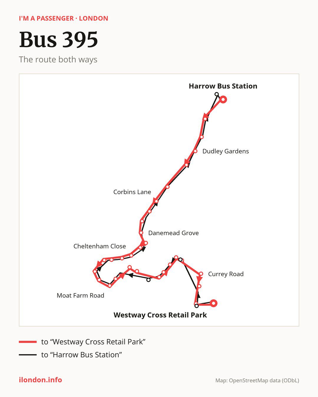
From “Harrow Bus Station” to “Westway Cross Retail Park”: 31 stops. On the way: “Roxborough Avenue”, “West Street Whitmore Road”, “Dudley Gardens”, “Grange Road (HA2)”, “South Harrow Station”, “Corbins Lane”, “St Gabriels Church South Harrow”, “Northolt Park Station”, “Danemead Grove”, “Northolt Fire Station”. Then “Newmarket Avenue”, “Cheltenham Close”, “Kempton Avenue”, “Sussex Crescent”, “Dabbs Hill Lane”, “Eastcote Lane”, “Islip Manor Park”, “Moat Farm Road”, “Northolt Station”, “Castle Road (UB5)”. Before “Westway Cross Retail Park”: “Briar Crescent”, “Castle Road / Glamis Way”, “The Fairway / Glamis Way”, “Raglan Way”, “Orchard Close / The Fairway”, “Oldfield Circus / Wadham Gdns”, “Currey Road”, “Auriol Drive (UB6)”, “Greenford Station / Rockware Avenue”.
The return journey is different. Towards “Harrow Bus Station”: 27 stops. Only in this direction does it call at “Rockware Avenue/Greenford Stn”, “Oldfield Circus / Carr Road”, “Castle Road / Oriel Way” and “St Georges Centre”. Only in the direction of “Westway Cross Retail Park” does it call at, among others, “Northolt Fire Station”, “Dabbs Hill Lane”, “Castle Road (UB5)”, “Briar Crescent”, “Raglan Way” and “Oldfield Circus / Wadham Gdns”. For the way back, board nearby: “Northolt Fire Station” → “Newmarket Avenue” (150 m), “Dabbs Hill Lane” → “Sussex Crescent” (150 m), “Castle Road (UB5)” → “Kempton Avenue” (250 m) and “Briar Crescent” → “Castle Road / Oriel Way” (300 m). Towards “Westway Cross Retail Park”, board nearby: “Rockware Avenue/Greenford Stn” → “Greenford Station / Rockware Avenue” (50 m), “Oldfield Circus / Carr Road” → “Oldfield Circus / Wadham Gdns” (50 m), “Castle Road / Oriel Way” → “Castle Road / Glamis Way” (200 m) and “St Georges Centre” → “Harrow Bus Station” (150 m).
Left column runs down, right column runs up. Filled stops are served both ways, dashed ones only one way: 8 towards “Westway Cross Retail Park” and 4 the other way. Tap a stop to see its name.
Connections
Shared sections with other routes: between “Grange Road (HA2)” and “Northolt Fire Station” it shares the road with route 140; between “South Harrow Station” and “Danemead Grove” it shares the road with routes 398 and 487.
Connections by stop, in route order:
- “Harrow Bus Station”: buses 114, 182, 183, 186, 223, 258, 340, 483, H11, H14, H17, SL9 and SL10
- “Roxborough Avenue”: buses 114 and H11
- “West Street Whitmore Road”: buses 114 and H11
- “Dudley Gardens”: buses 114 and 258
- “Grange Road (HA2)”: buses 114 and 258
- “South Harrow Station”: buses 114, 258, H12 and SL9
- “Corbins Lane”: buses 114, H12 and SL9
- Stops from “St Gabriels Church South Harrow” to “Danemead Grove”: bus SL9
- “Kempton Avenue”: buses 90, 120, 282 and SL9
- “Sussex Crescent”: buses 90, 120, 282 and SL9
- “Dabbs Hill Lane” (only towards “Westway Cross Retail Park”): bus 282
- “Eastcote Lane”: buses 282 and E10
- Stops from “Islip Manor Park” to “Northolt Station”: buses 90, 120, 282, E10 and SL9
- “Castle Road (UB5)” (only towards “Westway Cross Retail Park”): buses 90, 120, 282 and SL9
- “Briar Crescent” (only towards “Westway Cross Retail Park”): buses 90, 120, 282 and SL9
- “Currey Road” (only towards “Westway Cross Retail Park”): bus 92
- “Auriol Drive (UB6)”: buses 92, 105 and E6
- “Greenford Station / Rockware Avenue” (only towards “Westway Cross Retail Park”): buses 92, 105 and E6
- “Westway Cross Retail Park”: buses 92, 105 and E6
- “Rockware Avenue/Greenford Stn” (only towards “Harrow Bus Station”): buses 92, 105 and E6
- “St Georges Centre” (only towards “Harrow Bus Station”): buses 114, 182, 183, 223, 258, 340, 483, H11, H14, H17, SL9 and SL10
Pages for these routes: bus E10, bus E6, bus H11, bus H12, bus H14, bus H17, bus SL10, bus SL9, bus 90, bus 92, bus 105, bus 114, bus 120, bus 140, bus 182, bus 183, bus 186, bus 223, bus 258, bus 282, bus 340, bus 398.
Passes and concessions
Which passes are available and who travels free is explained on a separate page: how to pay for public transport in London.
Questions and answers
Does bus 395 go to “South Harrow Station”?
Yes, in both directions.
Where can I change from bus 395 to another bus route?
Most routes stop at “Harrow Bus Station” (114, 182, 183, 186, 223, 258, 340, 483, H11, H14, H17, SL9 and SL10) and “St Georges Centre” (only towards “Harrow Bus Station”; 114, 182, 183, 223, 258, 340, 483, H11, H14, H17, SL9 and SL10). All other stops with connections are listed above.
Checked on 26 September 2026. Source of the route and stops: Transport for London (TfL).