
Bus route 115 in London goes from “East Ham / Central Park” to “Aldgate”.
Where bus 115 goes
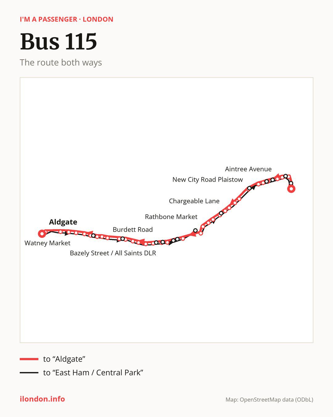
Towards “Aldgate”: 37 stops. After “East Ham / Central Park”, the bus calls at “Tilbury Road”, “Newham Town Hall”, “Bartle Avenue”, “Aintree Avenue”, “Dickens Road”, “Upton Park / Priory Road”, “Upton Park Green Street”, “New City Road Plaistow”, “Plaistow Prince Regent Lane”, “Plaistow Police Station”. Then “Balaam Street”, “Chargeable Lane”, “Croydon Road (E13)”, “Rokeby School”, “Hermit Road”, “Rathbone Market”, “Canning Town”, “Abbott Road South Bromley”, “Blackwall Tunnel”, “Bazely Street / All Saints DLR”. Then “Poplar Recreation Ground / DLR”, “Upper North Street”, “University of Cumbria in London”, “Burdett Road”, “Limehouse Town Hall”, “Lowell Street”, “Limehouse”, “Stepney Methodist Church”, “Marion Richardson School”, “Exmouth Estate”. Before “Aldgate”: “St Mary’s & St Michael’s Church”, “Watney Market”, “New Road (E1)”, “Henriques Street”, “Aldgate East”.
On the way back the bus takes a different route, from “Aldgate” to “East Ham / Central Park” (40 stops). Only in this direction does it call at “Arbour Square”, “Salmon Lane”, “Chrisp Street Market / All Saints DLR”, “Bazely Street”, “Brunswick Road (E14)”, “Nutmeg Lane”, “Stephenson Street”, “King Street (E13)”, “Samson Street”, “Arragon Road (E6)”, “Katherine Road Upton Park”, “High Street North East Ham” and “Market Street”. Only in the direction of “Aldgate” does it call at, among others, “Tilbury Road”, “Aintree Avenue”, “Dickens Road”, “Chargeable Lane”, “Croydon Road (E13)” and “Blackwall Tunnel”. For the way back, board nearby: “Tilbury Road” → “Market Street” (50 m), “Aintree Avenue” → “Katherine Road Upton Park” (200 m), “Dickens Road” → “Arragon Road (E6)” (50 m) and “Chargeable Lane” → “King Street (E13)” (150 m). Towards “Aldgate”, board nearby: “Arbour Square” → “Exmouth Estate” (100 m), “Salmon Lane” → “Limehouse Town Hall” (100 m), “Chrisp Street Market / All Saints DLR” → “Poplar Recreation Ground / DLR” (100 m) and “Bazely Street” → “Bazely Street / All Saints DLR” (50 m).
Left column runs down, right column runs up. Filled stops are served both ways, dashed ones only one way: 11 towards “Aldgate” and 14 the other way. Tap a stop to see its name.
Other routes along the way
On part of the route, between “Bazely Street / All Saints DLR” and “Aldgate” it shares the road with route 15; between “Newham Town Hall” and “Canning Town” it shares the road with route 5; between “Limehouse Town Hall” and “Aldgate East” it shares the road with route 135.
Connections by stop, in route order:
- “East Ham / Central Park”: buses 101, 300, 304, 376 and 474
- “Tilbury Road” (only towards “Aldgate”): buses 101, 304, 376 and 474
- “Newham Town Hall”: buses 101, 147, 238, 300, 304, 325, 376 and 474
- “Bartle Avenue”: buses 101, 147, 238, 300, 304, 325, 376 and 474
- “Aintree Avenue” (only towards “Aldgate”): buses 101, 147, 238, 300, 304, 325, 376 and 474
- “Dickens Road” (only towards “Aldgate”): buses 104 and 147
- “Upton Park / Priory Road”: buses 104, 147 and 376
- “Upton Park Green Street”: buses 104, 147 and 376
- “New City Road Plaistow”: buses 147, 262, 376 and 473
- “Plaistow Prince Regent Lane”: buses 147, 241, 262, 325 and 473
- “Plaistow Police Station”: buses 147, 241, 262, 300, 325 and 473
- “Balaam Street”: buses 241, 300 and 325
- “Chargeable Lane” (only towards “Aldgate”): buses 241, 300 and 325
- “Croydon Road (E13)” (only towards “Aldgate”): bus 300
- “Rokeby School”: buses 69, 300 and 474
- “Hermit Road”: buses 69, 300, 323 and 474
- “Rathbone Market”: buses 69, 147, 300, 309, 323 and 474
- “Canning Town”: buses 69, 147, 300, 309, 323 and 474
- “Abbott Road South Bromley”: buses 309, D3 and SL4
- “Blackwall Tunnel” (only towards “Aldgate”): buses 108, 309, D6, D7 and D8
- “Bazely Street / All Saints DLR” (only towards “Aldgate”): buses 108, 309, D6, D7 and D8
- “Poplar Recreation Ground / DLR”: buses 108, 309, D6, D7 and D8
- “Upper North Street”: buses 309 and D6
- “University of Cumbria in London”: buses 277, D3, D6 and D7
- “Burdett Road”: buses 277, D3, D6 and D7
- “Limehouse Town Hall” (only towards “Aldgate”): buses 277, D3, D6 and D7
- Stops from “Lowell Street” to “Stepney Methodist Church”: bus D3
- “Marion Richardson School” (only towards “Aldgate”): bus D3
- “Exmouth Estate” (only towards “Aldgate”): bus 339
- “St Mary’s & St Michael’s Church”: bus 339
- “Watney Market”: buses 339 and D3
- “New Road (E1)”: bus D3
- “Henriques Street”: buses 25, 205, 254 and D3
- “Aldgate East”: buses 25, 42, 78, 100, 205, 242 and 254
- “Aldgate”: buses 25, 42, 78, 100, 205, 242 and 254
- “Aldgate Bus Station”: buses 25, 42, 78, 100, 205, 242, 254 and 343
- “Salmon Lane” (only towards “East Ham / Central Park”): buses 277, D3, D6 and D7
- “Chrisp Street Market / All Saints DLR” (only towards “East Ham / Central Park”): buses 108, 309, D6, D7 and D8
- “Bazely Street” (only towards “East Ham / Central Park”): buses 108, 309, D6, D7 and D8
- “Brunswick Road (E14)” (only towards “East Ham / Central Park”): buses 108 and D8
- “Nutmeg Lane” (only towards “East Ham / Central Park”): buses 108 and 309
- “Stephenson Street” (only towards “East Ham / Central Park”): buses 69, 147, 300, 309, 323 and 474
- “King Street (E13)” (only towards “East Ham / Central Park”): buses 241, 300 and 325
- “Samson Street” (only towards “East Ham / Central Park”): buses 104, 147 and 376
- “Arragon Road (E6)” (only towards “East Ham / Central Park”): buses 104 and 147
- “Katherine Road Upton Park” (only towards “East Ham / Central Park”): bus 147
- “High Street North East Ham” (only towards “East Ham / Central Park”): buses 101, 147, 238, 300, 304, 325, 376 and 474
- “Market Street” (only towards “East Ham / Central Park”): buses 101, 147, 238, 300, 304, 325, 376 and 474
Pages for these routes: bus D3, bus D6, bus D7, bus D8, bus SL4, bus 5, bus 15, bus 25, bus 42, bus 69, bus 78, bus 100, bus 101, bus 104, bus 108.
Passes and concessions
Which passes are available and who travels free is explained on a separate page: how to pay for public transport in London.
Questions about bus 115
Does bus 115 go to “Newham Town Hall”?
Yes, in both directions.
Where can I change from bus 115 to another bus route?
Most routes stop at “Newham Town Hall” and “Bartle Avenue” (101, 147, 238, 300, 304, 325, 376 and 474). All other stops with connections are listed above.
Checked on 3 October 2026. Source of the route and stops: Transport for London (TfL).