
Bus route H98 in London goes from “School Road (TW3)” to “Wood End Green Road”. The return journey ends at “Hounslow Bus Station” (150 m from “School Road (TW3)”).
Where bus H98 goes
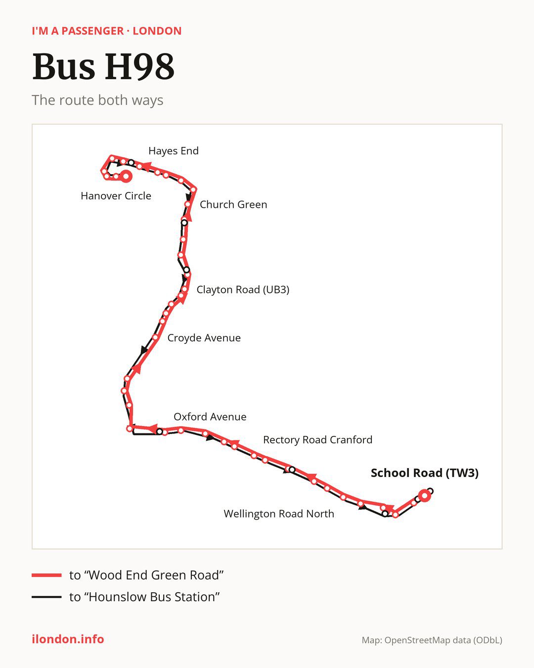
From “School Road (TW3)” to “Wood End Green Road”: 42 stops. On the way: “Fairfields Road”, “Treaty Centre”, “Bell Corner / Hounslow House”, “St Michael & St Martin Church”, “Wellington Road North”, “St Pauls Church”, “Hounslow West Station”, “Great West Road / Basildene Road”, “Henlys Roundabout”, “Rectory Road Cranford”. Then “The Parkway Cranford”, “The Avenue Cranford”, “Waye Avenue”, “Craneswater”, “Oxford Avenue”, “Harlington Corner”, “West End Lane (Harlington)”, “Harlington High Street / Sipson Lane”, “Brickfield Lane Harlington”, “Croyde Avenue”. Then “Redmead Road”, “Millington Road”, “Fairey Corner”, “Hayes & Harlington Station”, “Clayton Road (UB3)”, “Hayes Town Centre”, “Botwell Lane”, “Townfield Road”, “Freemans Lane”, “Church Green”. Before “Wood End Green Road”: “Church Road / Swift Close”, “Uxbridge County Court”, “Rosedale Park”, “Park Road (UB4)”, “Hayes End”, “Morgans Lane”, “New Road Hayes End”, “Green Lane (UB8)”, “York Avenue”, “Hanover Circle”.
The return journey is different. Towards “Hounslow Bus Station”: 42 stops. Only in this direction does it call at, among others, “Hayes Police Station”, “Longmead Road”, “Botwell Green”, “Nobel Drive”, “Great West Road / Renfrew Road” and “The Bell”. Only in the direction of “Wood End Green Road” does it call at, among others, “Fairfields Road”, “Bell Corner / Hounslow House”, “Great West Road / Basildene Road”, “Millington Road”, “Clayton Road (UB3)” and “Freemans Lane”. For the way back, board nearby: “Fairfields Road” → “Hounslow High Street” (100 m), “Bell Corner / Hounslow House” → “The Bell” (100 m), “Great West Road / Basildene Road” → “Great West Road / Renfrew Road” (50 m) and “Millington Road” → “Redmead Road” (150 m). Towards “Wood End Green Road”, board nearby: “Hayes Police Station” → “Morgans Lane” (150 m), “Longmead Road” → “Freemans Lane” (50 m), “Botwell Green” → “Hayes Town Centre” (100 m) and “Nobel Drive” → “Oxford Avenue” (100 m).
Left column runs down, right column runs up. Filled stops are served both ways, dashed ones only one way: 8 towards “Wood End Green Road” and 8 the other way. Tap a stop to see its name.
Connections
Shared sections with other routes: between “Harlington Corner” and “Morgans Lane” it shares the road with route 278; between “School Road (TW3)” and “Harlington Corner” it shares the road with route 222; between “Harlington Corner” and “Hayes Town Centre” it shares the road with route 90.
Connections by stop, in route order:
- “School Road (TW3)”: buses 110, 111, 116, 117, 120, 235, 237, 281, 423, E8, H22, H28 and H37
- “Fairfields Road” (only towards “Wood End Green Road”): buses 110, 111, 116, 117, 120, 235, 237, 281, 423, E8, H22, H28 and H37
- “Treaty Centre”: buses 110, 111, 116, 117, 120, 235, 237, 281, 423, E8, H20, H22 and H28
- “Bell Corner / Hounslow House” (only towards “Wood End Green Road”): buses 110, 111, 116, 117, 120, 235, 237, 281, 423, E8, H20, H22 and H28
- “St Michael & St Martin Church”: buses 116, 117, 235, 237 and 423
- “Wellington Road North”: bus H28
- “St Pauls Church”: buses 482, H28 and H91
- “Hounslow West Station”: buses 482 and H91
- “Great West Road / Basildene Road” (only towards “Wood End Green Road”): bus 482
- “Henlys Roundabout”: bus 482
- “Rectory Road Cranford”: bus 482
- Stops from “The Parkway Cranford” to “Oxford Avenue”: buses 105 and 111
- “Harlington Corner”: buses 105, 111, 285, 423 and SL9
- “West End Lane (Harlington)”: buses 105, 111 and SL9
- “Harlington High Street / Sipson Lane”: bus SL9
- “Brickfield Lane Harlington”: bus SL9
- “Croyde Avenue”: buses E6 and U4
- “Redmead Road”: buses 140, 350, E6 and U4
- “Millington Road” (only towards “Wood End Green Road”): buses 140, 350, E6, U4 and U5
- “Fairey Corner”: buses 140, 350, E6, SL9, U4 and U5
- “Hayes & Harlington Station”: buses 140, 350, E6, SL9, U4 and U5
- “Clayton Road (UB3)” (only towards “Wood End Green Road”): buses 140, 350, E6, SL9, U4 and U5
- “Hayes Town Centre”: buses 140, 350, E6, SL9, U4 and U5
- “Botwell Lane”: buses 140, 350, E6, SL9 and U4
- “Townfield Road”: buses 350 and U4
- “Church Green”: buses 427 and U7
- Stops from “Church Road / Swift Close” to “Rosedale Park”: buses 427, SL8 and U7
- “Park Road (UB4)”: buses 427 and SL8
- “Hayes End”: buses 427 and SL8
- “Morgans Lane” (only towards “Wood End Green Road”): buses 427, SL8 and U7
- “New Road Hayes End”: buses 427 and U7
- “Green Lane (UB8)”: buses 427 and U7
- “York Avenue”: bus U7
- “Hanover Circle”: buses 427 and U7
- “Wood End Green Road”: buses 427 and SL8
- “Hayes Police Station” (only towards “Hounslow Bus Station”): buses 427 and SL8
- “Botwell Green” (only towards “Hounslow Bus Station”): buses 140, 350, E6, SL9 and U4
- “Nobel Drive” (only towards “Hounslow Bus Station”): buses 105 and 111
- “Great West Road / Renfrew Road” (only towards “Hounslow Bus Station”): buses 482 and H91
- “The Bell” (only towards “Hounslow Bus Station”): buses 110, 111, 116, 117, 120, 235, 237, 281, 423, E8, H20, H22 and H28
- “Hounslow High Street” (only towards “Hounslow Bus Station”): buses 110, 111, 116, 117, 120, 235, 237, 281, 423, E8, H22, H28 and H37
- “Hounslow Bus Station”: buses 110, 111, 116, 117, 120, 235, 237, 281, 423, E8, H22, H28 and H37
Pages for these routes: bus E6, bus E8, bus H20, bus H22, bus H28, bus H37, bus H91.
Passes and concessions
Our page “How to pay for public transport in London” describes tickets, passes and concessions, including any differences between modes of transport.
Questions about bus H98
Does bus H98 go to “Hounslow West Station”?
Yes, in both directions.
Where can I change from bus H98 to another bus route?
Most routes stop at “School Road (TW3)” (110, 111, 116, 117, 120, 235, 237, 281, 423, E8, H22, H28 and H37) and “Fairfields Road” (only towards “Wood End Green Road”; 110, 111, 116, 117, 120, 235, 237, 281, 423, E8, H22, H28 and H37). All other stops with connections are listed above.
Checked on 26 September 2026. Source of the route and stops: Transport for London (TfL).