

Bus route G1 in London links “Hermitage Lane” and “Shaftesbury Estate / Wickersley Road”. In one direction or the other it serves 3 stops that it skips on the way back.
The route of bus G1
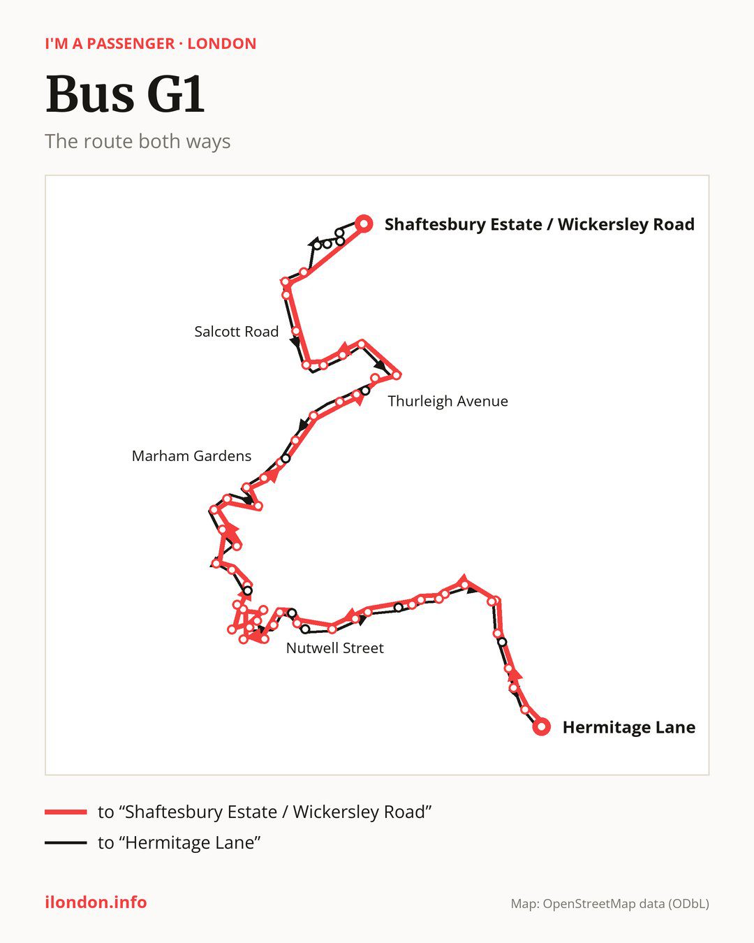
From “Hermitage Lane” to “Shaftesbury Estate / Wickersley Road”: 53 stops. On the way: “Arragon Gardens”, “Kempshott Road”, “Streatham Common High Road”, “Streatham Station”, “St Leonard’s Church”, “Streatham / St Leonard’s Church”, “Garrads Road”, “Aldrington Road / North”, “Ullathorne Road / Colson Way”, “Ullathorne Road”. Then “Clairview Road”, “Church Lane / Furzedown Road”, “Church Lane / Lessingham Avenue”, “Church Lane / Eswyn Road”, “Bickley Street”, “Tooting Broadway Station”, “Tooting Bwy/South Thames Coll”, “Nutwell Street”, “Longley Road”, “St George’s Hospital”. Then “St George’s / University of London”, “St George’s/Lanesborough Wing”, “St George’s Hosp/Main Entrance”, “St George’s Hospital / St James Wing”, “St George’s/Knightsbridge Wing”, “National Blood Service”, “Fairlight Road”, “Streatham Cemetery”, “Wimbledon Road”, “St George’s Grove”. Then “Grosvenor Way”, “Burntwood School”, “Openview”, “Springfield University Hospital”, “Tilehurst Road”, “Marham Gardens”, “Trinity Road (SW17)”, “Wandsworth Common”, “Bolingbroke Grove / Ravenslea Road”, “Oak Lodge School”. Then “Ramsden Road Balham”, “Thurleigh Avenue”, “Clapham South”, “Broomwood Road”, “Broomwood Road / Alfriston Road”, “Broomwood Road / Hillier Road”, “Darley Road”, “Salcott Road”, “Clapham Junction / The Northcote”, “Clapham Junction Station / The Falcon”. Before “Shaftesbury Estate / Wickersley Road”: “Lavender Hill Police Station”.
The return journey is different. Towards “Hermitage Lane”: 54 stops. Only in this direction does it call at, among others, “Eversleigh Road / Battersea”, “Grayshott Road”, “Sabine Road / Eland Road”, “Sabine Road / Elsley Road”, “Bracken Avenue” and “Bellevue Road / Trinity Road”. Only in the direction of “Shaftesbury Estate / Wickersley Road” does it call at, among others, “Kempshott Road”, “Bickley Street”, “Tooting Bwy/South Thames Coll”, “Longley Road”, “St George’s Hospital” and “St George’s/Knightsbridge Wing”. For the way back, board nearby: “Kempshott Road” → “Streatham Common High Road” (250 m), “Bickley Street” → “Tooting / The Mitre” (100 m), “Tooting Bwy/South Thames Coll” → “Tooting Broadway Station” (150 m) and “Longley Road” → “Nutwell Street” (200 m). Towards “Shaftesbury Estate / Wickersley Road”, board nearby: “Eversleigh Road / Battersea” → “Shaftesbury Estate / Wickersley Road” (300 m), “Bracken Avenue” → “Ramsden Road Balham” (100 m), “Bellevue Road / Trinity Road” → “Trinity Road (SW17)” (100 m) and “Fountain Road / Garrett Lane” → “Fairlight Road” (50 m).
Left column runs down, right column runs up. Filled stops are served both ways, dashed ones only one way: 10 towards “Shaftesbury Estate / Wickersley Road” and 11 the other way. Tap a stop to see its name.
Connections
Shared sections with other routes: between “St George’s / University of London” and “Fairlight Road” it shares the road with route 493; between “Hermitage Lane” and “St Leonard’s Church” it shares the road with routes 50, 109, 250 and 255; between “Tooting Broadway Station” and “Longley Road” it shares the road with route 219.
Connections by stop, in route order:
- “Kempshott Road” (only towards “Shaftesbury Estate / Wickersley Road”): buses 45 and 60
- “Streatham Common High Road”: buses 45, 60 and 249
- “Streatham Station”: buses 45, 57, 60, 133, 159, 201, 249, 315, 333 and P13
- “St Leonard’s Church”: buses 45, 57, 60, 133, 159, 201, 249, 315, 319, 333 and P13
- “Streatham / St Leonard’s Church”: buses 45, 57, 60, 133, 159, 201, 249, 315, 319, 333 and P13
- “Garrads Road”: buses 57, 201, 249, 315, 319 and 333
- Stops from “Aldrington Road / North” to “Clairview Road”: buses 249 and 319
- “Church Lane / Eswyn Road”: buses 44, 57, 77, 127, 264, 270, 280, 333 and 355
- “Bickley Street” (only towards “Shaftesbury Estate / Wickersley Road”): buses 44, 57, 77, 127, 131, 155, 264, 270, 280, 333 and 355
- “Tooting Broadway Station”: buses 44, 57, 77, 127, 131, 155, 264, 270, 280, 333 and 355
- “Tooting Bwy/South Thames Coll” (only towards “Shaftesbury Estate / Wickersley Road”): buses 44, 57, 77, 127, 131, 155, 264, 270, 280, 333 and 355
- “Nutwell Street”: buses 44, 57, 77, 127, 131, 155, 264, 270, 280, 333 and 355
- “Longley Road” (only towards “Shaftesbury Estate / Wickersley Road”): buses 57, 131, 155, 264 and 280
- “St George’s Hospital” (only towards “Shaftesbury Estate / Wickersley Road”): buses 57, 131, 155, 264 and 280
- “St George’s / University of London”: buses 44, 77, 155, 264, 270 and 280
- “St George’s/Lanesborough Wing”: buses 44, 57, 77, 127, 131, 155, 264, 270, 280, 333 and 355
- “St George’s Hosp/Main Entrance”: buses 44, 57, 77, 131, 155, 264, 270 and 280
- “St George’s Hospital / St James Wing”: buses 57, 131, 155, 264 and 280
- “St George’s/Knightsbridge Wing” (only towards “Shaftesbury Estate / Wickersley Road”): buses 155, 264 and 280
- “National Blood Service” (only towards “Shaftesbury Estate / Wickersley Road”): buses 44, 77, 155, 264, 270 and 280
- “Fairlight Road” (only towards “Shaftesbury Estate / Wickersley Road”): buses 44, 77, 155, 264, 270 and 280
- “Streatham Cemetery”: buses 44, 77, 155, 264, 270 and 280
- “Wimbledon Road”: buses 44, 77 and 270
- “Grosvenor Way”: buses 44, 77 and 270
- Stops from “Openview” to “Tilehurst Road”: bus 315
- “Marham Gardens”: buses 315 and 319
- “Trinity Road (SW17)” (only towards “Shaftesbury Estate / Wickersley Road”): bus 319
- Stops from “Wandsworth Common” to “Oak Lodge School”: bus 319
- “Thurleigh Avenue” (only towards “Shaftesbury Estate / Wickersley Road”): buses 155, 249 and 355
- “Clapham South”: buses 155, 249 and 355
- “Broomwood Road / Hillier Road”: bus 319
- “Darley Road”: bus 319
- “Salcott Road”: buses 35, 37 and 319
- Stops from “Clapham Junction / The Northcote” to “Lavender Hill Police Station”: buses 35, 37, 39, 49, 77, 87, 156, 170, 295, 319, 337, 344, 345 and C3
- “Shaftesbury Estate / Wickersley Road”: buses 137, 156 and 452
- Stops from “Grayshott Road” to “Sabine Road / Elsley Road” (only towards “Hermitage Lane”): buses 77, 87, 156 and 345
- “Bellevue Road / Trinity Road” (only towards “Hermitage Lane”): bus 319
- “Fountain Road / Garrett Lane” (only towards “Hermitage Lane”): buses 44, 77, 155, 264, 270 and 280
- “Mitcham Road/Tooting Broadway” (only towards “Hermitage Lane”): buses 44, 57, 77, 127, 131, 155, 264, 270, 280, 333 and 355
- “Tooting / The Mitre” (only towards “Hermitage Lane”): buses 44, 57, 77, 127, 264, 270, 280, 333 and 355
- “Streatham United Reform Church” (only towards “Hermitage Lane”): buses 45, 60, 133, 159, 249 and P13
Pages for these routes: bus C3.
Passes and concessions
Our page “How to pay for public transport in London” describes tickets, passes and concessions, including any differences between modes of transport.
Questions and answers
Does bus G1 go to “Streatham Station”?
Yes, in both directions.
Where can I change from bus G1 to another bus route?
Most routes stop at “Clapham Junction / The Northcote” and “Clapham Junction Station / The Falcon” (35, 37, 39, 49, 77, 87, 156, 170, 295, 319, 337, 344, 345 and C3). All other stops with connections are listed above.
Checked on 1 October 2026. Source of the route and stops: Transport for London (TfL).